Map of 74 Things to do near Supai, Arizona
first prev 1 2 3 4 next lastShowing results within 50 miles Distance miles of Supai, AZ 86435, USA City, Zip, or Address

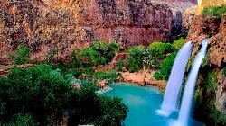
Havasu Falls and Mooney Falls Trail
Supai, Arizona
5.4 miles SThe Havasupai Indian Reservation is not part of the Grand Canyon National Park, but you cannot tell that from the scenery. From your very first step at the trailhead parking lot until...
Backpack, Camp, Hike
Havasupai Falls
Supai, Arizona
5.4 miles SThe Havasupai Reservation is located in one of the most beautiful and remote areas of the western Grand Canyon. The Village of Supai, is located in Havasu Canyon, a southwestern branch...
Backpack, Camp, Hike
Havasu Falls Trail
Flagstaff, Arizona
5.4 miles SBackpack, Dive, Horseback, and Swim near Flagstaff, Arizona
Backpack, Dive, Horseback, Swim
Havasu Canyon Trail
Supai, Arizona
5.5 miles SHike

Tuckup Trail
11.1 miles NW
Hike

Tapeats Creek to Deer Creek
North Rim, Arizona
15.3 miles NENOTE: The beginning of this hike is in a remote location. The nearest trailhead is Bill Hall trailhead. This is an excellent route ranging from the trackless beaches of the Colorado...
Backpack, Camp, Hike
South Bass Trail
Supai, Arizona
17.8 miles EThis is a strenuous, 15.6-mile (round-trip), remote, non-corridor hike in Grand Canyon National Park. Camping here is at large, as there are no established sites below the rim. There is...
Backpack, Camp, Hike
Bill Hall Trail
North Rim, Arizona
19.0 miles NEHike

Deer Creek to Colorado River
North Rim, Arizona
19.9 miles NEBackpack, Camp, Hike

Thunder River and Tapeats Creek Trail
North Rim, Arizona
19.9 miles NEThunder River Trail - Grand Canyon National Park (North Rim) is a 25 mile out and back trail located near North Rim, Arizona that features a river. The trail is only recommended for...
Backpack, Camp, Hike
Bill Hall Trail to Monument Point
North Rim, Arizona
19.9 miles NEBackpack, Hike

North Bass Trail
North Rim, Arizona
20.1 miles EDirections from North Rim Entrance Station: Drive northward to Forest Service Road (FSR) 422 and turn left. Follow 422 to FSR 270 and turn left. Drive approximately 3 miles to FSR 223...
Backpack, Camp, Hike
North Bass Trail to Muav Cabin
North Rim, Arizona
20.1 miles EBackpack, Hike

Powell Plateau Trail
North Rim, Arizona
20.1 miles EA rewarding plateau-top day hike or backpack to a remote North Rim plateau. Hikers who pack enough water can easily wander around the plateau for days, visiting various rim overlooks...
Backpack, Camp, Hike
Rainbow Rim Trail - North Rim of the Grand Canyon
North Rim, Arizona
21.1 miles NEThis incredibly sweet ride offers great views, ponderosa and aspen forest, all on a sweet single track. This sweet Grand Canyon ride will take you through some outstanding and remote...
Hike, Mountain Bike
North Rim Loop
North Rim, Arizona
21.9 miles NEMountain Bike

Hermits Rest Viewpoint to Dripping Springs Trail
Grand Canyon Village, Arizona
29.3 miles SEThe Dripping Springs and Hermit Trail out and back contains incredible views. Once you have passed Dripping Springs there are no trail markings so be sure to know exactly where you are at. The trail...
Backpack, Hike 7.7 mi
Waldron Trail
Grand Canyon Village, Arizona
29.3 miles SEAn alternative to the highly strenuous Hermit Trail, the Waldron Trail splits off from the Hermit Trail 1.2 miles in and is one of the shorter trails in the canyon at only 2 miles long. Open...
Hike
Hermit's Rest Viewpoint to Santa Maria Spring
Grand Canyon Village, Arizona
29.3 miles SELocated in Grand Canyon National Park, Hermit’s Rest Viewpoint to Santa Maria Spring trail features fantastic views in a peaceful setting. The trail is easy to follow as it is well maintained...
Backpack, Hike
Boucher Trail
Grand Canyon Village, Arizona
29.3 miles SEBoucher Trail is a 17.7 mile moderately trafficked out and back trail located near Grand Canyon, Arizona that features a river and is only recommended for very experienced adventurers. The trail is...
Backpack, Hike


