


10 Hiking Trails near Irish Boat Ramps
first prev 1 next lastShowing Hiking Trails within 50 miles Distance miles of 15199 ID-21, Boise, ID 83716, USA City, Zip, or Address
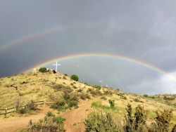
Table Rock
Boise, Idaho
7.8 miles WTable Rock is located directly above downtown Boise, Idaho and is part of the extreme southwestern portion of the Boise Mountains. It is recognizable by the tall white cross, that lights up. If...
Hike
Military Reserve Trails
Boise, Idaho
9.9 miles WThis 460 acre natural area is named for Ft. Boise and the associated military maneuvers that were performed here between the 1860's and 1940's. The area served several purposes, including...
Hike, Mountain Bike
Central Foothills
Boise, Idaho
10.8 miles WFrom foothills to mountain tops, Idaho's wilderness offers some of the best hiking in the country. With over 19,000 miles of trails, hikers can find everything from paved recreational trails...
Hike, Mountain Bike
Crater Rings
Mountain Home, Idaho
28.2 miles SCrater Rings are two adjacent and symmetrical pit craters that are among the few examples of this type of crater in the continental United States. The pit craters, which are volcanic conduits in...
Hike, Rock Climb
Halverson Lake
Melba, Idaho
32.5 miles SWHalverson Lake is a pond nestled along the canyonHalverson Bar wall with opportunities for camping, hiking, backpacking, biking, horseback riding, hunting, picnicking and scenic/wildlife viewing....
Hike, Horseback, Rock Climb
Mile Marker 4 (Skinnydipper Hotsprings)
Garden Valley, Idaho
35.0 miles NSkinnydipper is about a 45minute to 1 hour drive from Boise, followed by a 0.5 mile hike up steep switchbacks to the actual hot springs. Visiting should be avoided during inclement weather. Roads and...
Hike, Swim
Pine Flat Hot Springs
Garden Valley, Idaho
36.1 miles NEPine Flat Hot Springs is a popular soaking location near the Pine Flat Campgrounds. On the edge of the South Fork Payette River there are several hot springs moving up thee bank. The most popular of...
Camp, Canoe, Hike, Hot Springs, Kayak, Whitewater
Swinging Bridge Beach
Cascade, Idaho
43.5 miles NSwinging Bridge Campground is located 10 miles north of Banks, Idaho just off Highway 55 at an elevation of 4,000 feet. The North Fork Payette River flows next to the highway, where whitewater...
Hike, Swim
Jump Creek
Marsing, Idaho
47.3 miles WA surprising waterfall and lush riparian community filled with waterbirch and red osier dogwood trees. Visitors can hike the easy ¼ mile Jump Creek Falls Trail - you may get your feel wet!...
Canyoneer, Hike, Rock Climb, Swim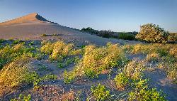
Bruneau Dunes
Bruneau, Idaho
48.8 miles SBruneau Dunes State Park is home to the tallest single structure sand dune in North America, standing 470 ft above small lakes and campgrounds. The park itself is home to a wide variety of...
Camp, Canoe, Hike, Horseback


