Refine Search
- hike 11
- camp 8
- canoe 5
- mountain bike 5
- cave 3
- disc golf 2
- rock climb 2
- horseback 2
- kayak 2
- swim 1
- sled 1
Dunraven Pass - Mount Washburn Trail
Canyon Village, Yellowstone National Park
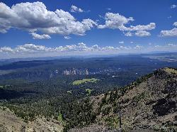
4.0 miles NE of Canyon Village, Yellowstone National ParkHikers looking for a scenic hike to the peak Mount Washburn will be pleased hiking the Mount Washburn Trail via Dunraven Pass. This trail winds through quiet forests to the peak.
The trailhead for this section of Mount Washburn Trail can be found at the parking lot for Dunraven Pass. The trail is out and back, starting and ending at the same trailhead.
The hike to the peak of Mount Washburn and back to Dunraven Pass is just over six miles and takes hikers between three and six hours to complete the hike. There is no drinking water available along the trail. Come prepared with enough water and snacks to take a successful hike.
Hikers on Mount Washburn Trail frequently see several forms of wildlife. During the summer months it is common to see bighorn sheep and wildflowers along the trail. In the fall grizzly bears are attracted to the white bark pine nuts in the area and are frequently seen near the trail. Be sure to always keep a safe distance from any wildlife in Yellowstone National Park.
At the peak of Mount Washburn there are spectacular views over Yellowstone National Park. These views can also be enjoyed from inside a small shelter building at the peak. This shelter has interactive exhibits that allow hikers to learn more about the area, as well as benches for resting.
This hike is open only in the summer and fall months, due to large amounts of snow in the winter and spring. It is not recommended that hikers use this trail in September or October.
The beautiful views of Yellowstone from the peak of Mount Washburn and the winding forested trail make the hike from Dunraven Pass a wonderful way to connect with nature.
Queen Anne Creek
Edenton, North Carolina
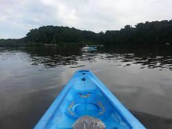
0.2 miles W of Edenton, North CarolinaLocals in Edenton recommend Queen Anne Creek for great kayaking and canoeing. To begin this adventure park your car at the Roanoke River Lighthouse and head across the park to the Edenton Marina. Don't have a boat? Kayak and canoe rentals are available at the harbor for 5-10 dollars an hour. The docks at the Marina are the perfect launch point.
Your adventure begins with a short paddle around the docks. The waves on the Albemarle Sound make this the most difficult part of the trek but also the most exciting. Once around the docs turn by Queen Anne Park onto Little Creek, and under Haysfarm Road Bridge. The water calms here and becomes easier to paddle through.
Paddling up the creek provides different views throughout the year. There are calm days that turn the creek into a mirror that makes it look like you are floating through the treetops. In the spring the lily pads are in bloom and coat Little Creek with their shiny green leaves and white blossoms. The vibrant colors of fall show so crisply it looks like someone painted them.
The paddle up and back lasts about two hours. Of course, it's a bit shorter for advanced kayakers and longer for those of us who just can't help but stop and stare.
Beaver Dick Park
Rexburg, Idaho
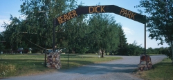
5.7 miles W of Rexburg, IdahoBeaver Dick is a park 4.5 miles west of Rexburg, Idaho on Hwy 33. It's a 9.5 acre park that passes next to the west bank of the Henry Fork of the Snake River; it's a popular place for swimming, fishing and other water activities such as boating and canoeing.
Within the campgrounds, there are fire pits, pavilions for social events and gatherings, bathrooms and a playground for the kids. It almost makes for good rounds of walks around the outskirts of the Snake River while enjoying the scenery.
History:
The park was named after an English-American named Richard Leigh. He was reportedly given the moniker "Beaver Dick" by LDS president Brigham Young for his beaver trapping abilities. As a young boy, he left England and moved to the United States to make a living as a fur trapper and eventually, fought in the Mexican war at 17 years old. He traveled throughout the Teton laying traps for beavers for fur, hunting and mapping out the Fire-Hole [Yellowstone Park], Jackson Hole and west of the Tetons in his journal. He became a fluent speaker of the Bannock and Shoshone language, met and married a native American woman named Jenny and had 6 children. The family adopted a child that contracted smallpox; the family of the child died. The family, including the adopted child, died of smallpox and Beaver Dick survived. He later remarried to a Bannock Indian named Susan Tadpole in 1979 and had 3 children. He lived the rest of his life as a mountain man but in 1899, he passed away of a serious illness and was buried beside his family overlooking his ranch in Rexburg, Idaho. He will be remembered as a skilled hunter, trapper and an expert in exploration and settlement of the Tetons, guiding travelers and explorers throughout the mountain west.
Tips:
-Bring water; there are no water fountains
-Bring life jackets in case of strong water currents during swimming
-Beaver Dick is open 7 days a week
-Make camping reservations in advance; first come, first serve
Camping Fees:
- $5 a night or $15 for all 5 day/night stays
For reservations, information, questions or concerns:
-Phone number: (208)-356-3139
-Website: https://www.co.madison.id.us/departments/parks-recreation/30-beaver-dick-park
The use of this field for playing paintball is now prohibited. Please take better care of the fields we are permitted to use.
Mammoth Hot Springs
Mammoth, Yellowstone National Park
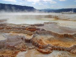
0.3 miles SW of Mammoth, Yellowstone National ParkMammoth Hot Springs is a unique sight in Yellowstone National Park. The soft limestone in this area allowed the water to form colorful terraces. The extremely hot running water is clear and smooth, covering the rock formations with a glistening surface.
Hiking in this area provides views of these colorful terraces from different vantage points. The boardwalk style trail is easy to climb, with a 300-foot elevation and a total distance of about 1 mile. Visitors can expect to see the entire trail in about an hour.
Hikers looking for a longer, more forested trail can find that hiking Beaver Ponds Trail. This trail is a little over 5 miles long and is true to its name. Ponds and trees surround the trail making this a wonderful place to escape the larger crowds of Yellowstone and connect with nature.
Like other areas of Yellowstone, abundant amounts of wildlife can be seen by Mammoth Hot Springs. This area is especially known for the many Elk that frequent the trails and parking lot.
There are 85 campsites available year-round in Mammoth Hot Springs. The campsites in Mammoth Campground can not be reserved and are available on a first come first served basis. These campsites provide for RV’s as well as tent campers. There are restrooms available at the campsites.
Mammoth Hot Springs is a wonderful place to visit when you are looking to see unique thermal activity and wildlife any time of year.
Umstead State Park
Raleigh, North Carolina
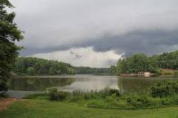
9.7 miles NW of Raleigh, North CarolinaPeople in North Carolina’s Triangle find respite in the natural haven that is William B. Umstead State Park. Umstead State Park is an impressive 5,579 acres of nature’s wonders in the middle of the bustling cities of Raleigh, Durham and Cary.
The forested expanse of this park contains over 20 miles of clearly marked hiking trails, and 13 miles of multi-use trails. Visitors use the multi-use trails for mountain biking, horseback riding and of course hiking. These trails vary from beginner to intermediate in difficulty. No matter what your level is, there is a trail waiting to be explored.
The three lakes in the park provide stunning views from many of the trails and for fishermen as they patiently wait for a catch. Fishing is allowed on all lakes and streams in the park. Fishing is available year-round. North Carolina fishing regulations are enforced.
Canoes can be rented at Big Lake on summer weekends. Big Lake is the largest of the three lakes. Tent and group campsites are available for reservations from March 15th through December 1st each year.
Umstead State Park is divided into two sections, Crabtree Creek and Reedy Creek and is easily accessible from Interstate 40 and US 70. The easy access, variety of activities and connection to nature make William B. Umstead State Park a place you will want to visit throughout the year.

Lava Flow Campground
Arco, Idaho
17.7 miles SW of Arco, IdahoAs unique as its name, campsites are surrounded by a young lava flow. The campground is located near the visitor center and popular trails. Campground opened on May 30. Campground generally closes when the Loop Road closes in late November. (Road and campground closures are weather dependent. Check the Current Conditions page for updates.) 42 sites are available on a first come-first served basis; no reservations are accepted. $15 per site during the main season and $8 per site when water is not turned on to the campground. The cost is half-price with Senior or Access passes. Pay with a credit card at any time on the automated fee machine located near the campground entrance. No fee charged during the very late and early seasons (November & April).Courtesy of nps.gov

St. Anthony Sand Dunes
Saint Anthony, Idaho
6.0 miles NW of Saint Anthony, IdahoBest known for their offroad riding conditions, the St. Anthony Sand Dunes provide a sledding experience unlike any other. These mountains of sand are fun for sliding down in the summer but during the winter, you won't find a smoother surface for the snow. There are hills everywhere you look and it doesn't take much to find a bowl or halfpipe like experience.
City of Rocks National Reserve
Malta, Idaho
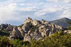
23.3 miles SW of Malta, IdahoThe City of Rocks, or "The City" as locals call it, is one of the best places in the country to go rock climbing. Throughout the valley granite spires dominate the skyline, reaching anywhere from 30-600 ft. Because there are so many rocks that can be climbed, the level of difficulty ranges from 5.6 all the way to 5.13. There are over 700 devloped routes throughout the reserve, with different options for climbing like trad or sport climbing. Unlike most climbing spots, City of Rocks allows a full range of technique in one location, making it the perfect place for both the new climber and the seasoned, technical climber. Permits are not required to climb, though climbing is not allowed on any rocks within the California Trail Corridor.
Some of the more popular areas to climb are the Bread Loaves, Bath Rock, Parking Lot Rock, Elephant Rock, and Treasure Rock. Each of these rocks may have routes as easy as a 5.6 right next to something as difficult as a 5.11. Most of these rocks have parking lots in close proximity to the rocks. The parking lot for Bath Rock includes a water spout and bathrooms. Campgrounds can be found throughout the reserve, though they do require a fee. Many routes will only have two or three permanent bolts on the rock, requiring additional equipment for setting up routes. In order to preserve the natural beauty of the city regulations were put in place for rock climbers. Be aware of different regulations before going to the city.
Bread Loaves offers some of teh most well known and climbed routes in the reserve. Walls such as Decadent Wall include routes that go from a 5.7 to a 5.11a. One of the most popular climbs is known as Carole's Crack, a 5.8 featuring a double crack at the top. Many people will rappel down from the top or practice lead climbing on these routes. The best time to climbthese routes is during the morning because they aren't being hit by the sun. As the day goes on, shade will become scarce around the walls.
Bath Rock has a large parking lot with views of the valley as well as some nice campgrounds. On top of Bath Rock has a wide variety of routes as well, with routes ranging from 5.4 to 5.12c. There are some good climbs to introduce new climbers to crack climbing. At the top, climbers will be greated by a nice view of all the other peaks in the area they can climb. On the west side, there is a clear trail with steps leading to the routes, as well as fences built near the wall to keep people from harming the nature.
There is plenty of history in City of Rocks, both climbing history as well as pioneer history. Many pioneers used to come through this area on the California Trail and signed their names on some of the surrounding rocks with axle grease. The climbing history does not date back as far as the pioneers, but began in the 1960's. Today there is a rock climbing festival held in the park every September. This festival offers introduction to climbing courses, as well as demo's of different climbing projects and a lot of climbing. During the summer the park services offer climbing classes for any interested.
Shoshone Falls Park
Twin Falls, Idaho
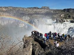
3.7 miles NE of Twin Falls, IdahoThe view of Shoshone Falls is beautiful year round but it is simply breathtaking during spring runoff when the water levels are high and they roar so hard you can feel the mist hundreds of feet above the water. There are multiple platforms for viewing as well as information placards and a little gift stand. The park is owned and managed by the city of Twin Falls who charge a fee of $3 per carload (as of 4/1/2017).
The canyon rim trail goes up the canyon wall on the Southwest end of the falls and continues along the rim taking you to the site of Evel Kneival's 1974 attempt to jump the Snake River Canyon. To the jump site and back is about 2.5 miles round trip.

North Menan Butte ('R' Mountain)
Menan, Idaho
4.5 miles N of Menan, IdahoThe North Menan Butte is more commonly known to the locals and college students as R Mountain. Many kids know it better as Ou'R' Mountain. The butte is a rare and unique geological area and provides a great volcanic hike.
There's a paved parking lot and a vault toilet at the West trailhead. The first few hundred yards are well-maintained gravel and sand paths and the further you get, the less defined the trail gets, though it is relatively easy to find and follow. The switchback trails (South and West) are marked by sections of log fences. Towards the top of the West switchbacks, there's a chain handrail. It gets a little steep so you'll want some shoes with some grip. The sand on the rock makes it pretty slippery in the steeper parts. You'll get better grip after a good rain. Once you get up to the top, there's an informational placard. From there, it's easy to hike the rim and get an awesome view of the valley including Rexburg, Henry's Fork, and the Snake River.
It's a great hike for a small family or just a quick hike for a date. Even going up the West switchbacks and around rim, including the 'R', and back down the same way is only 3.5 miles (longest route) so you can do it pretty quick if you want. There's so much to look at that you could also spend hours climbing rocks, exploring caves, and playing around "The Ampitheater". If you just want to get to the 'R' as quickly as possible, you can do the hike in as little as 2 miles roundtrip.
Distances:
- West trailhead up the face to the rim: 0.5 miles
- West trailhead up the switchbacks to the rim: 0.75 miles
- West trailhead, from reaching the rim to 'R': 1 mile
- South trailhead to the rim: 0.3 miles
- South trailhead, from reaching the rim to 'R': 0.75 mile
- Through the caldera: 0.6 miles
- Around the rim: 2 miles
- Rim to 'R': 500 feet
There are no fees. Camping is allowed up to 5 nights but fires must be in an elevated fire pan and all the ash must be packed out.
Posted regulations:
- No motorized vehicle use
- Discharging of weapons or fireworks is prohibited
- Open fires are permitted only with an approved elevated fire pan and ash removal
- Burning pallets, tires, wire, plastic, glass, metal, magnesium, or hazardous material is prohibited
- Cutting or damaging vegitation is prohibited
- 5-day camping limit
The Rimrocks
Billings, Montana
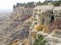
4.5 miles W of Billings, MontanaThe Billings Rimrocks(The Rims), the often neglected and unjustly overlooked climbing mecca of eastern Montana. The most popular climbing area is above the Gregory Hills subdivision. There are some great cracks and some great although sometimes fragile face climbs. Toproping is the norm because of the aforementioned rock quality although cracks usually take good medium to large sized pro. There are a few bolted routes but choose your poison. Most routes have easily accessable bolt or natural anchors. A great local winter climbing destination but avoid it during the heat of the summer after 10:00am! Also be aware of the very high rockfall potential and belay and hang out well away from the base of the climbs and as always pack out all trash including cigarette butts and tape.
Rexburg Nature Park
Rexburg, Idaho
0.8 miles NW of Rexburg, IdahoRexburg Nature Park:
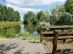
Life can be stressful, annoying, or just not good. Sometimes, it takes a moment to simply get away from the non-sense of this world; to gather yourself and seek peace and tranquility. That option is around the corner; you drive and see a trail, so you park and walk on the trail. As you walk, there's trees and sunlight shining on the leaves. You walk further and see a pond with ducks (both green and brown) and families sitting on the green grass with their kids; they watch, feed the ducks and take pictures with a smile on their face.
You go back to your vehicle and reminisce what you saw. Close to the south fork of the Teton River, is a nature park that isn't crowded with college students or infested with incoming traffic but a 15 acre park that was made so you can take your family or acquaintances for a picnic or a social gathering and enjoy; you also have the option to ride your bike or to jog on the trails.
The park is next to the Claire Boyle skate park, a beautiful golf course next to the fairgrounds and a 9 hole Frisbee golf course.
Features:
-Playground for the kids
-Fishing ponds ( A valid fishing license is required); fishing ponds for children as well.
-Wildlife and wildflowers
For more information and questions:
| Phone | 208-359-3020 Ext. 0 |
Lewis & Clark Caverns
Whitehall, Montana
10.9 miles E of Whitehall, MontanaThe Lewis & Clark Caverns State Park encompasses 3,015 acres that you can explore by foot, on a bike, in a canoe or in a tent.
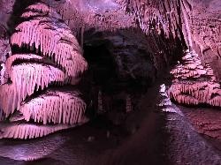
The most famous feature of the park is the Lewis & Clark Caverns themselves. The caverns can be accessed via guided tour from May 1st to September 30th each year. The guided tour is well lit and allows visitors to witness a variety of colorful formations in several different rooms. Even in the heat of the summer months the cave remains a cool, humid 48 degrees Fahrenheit.
The cave entrance and exit are at a higher elevation than the visitor center. This gives visitors a short hike to take. The hike is a little over one mile.
Tour tickets can be purchased at the visitor’s center and cost $10 for adults, $5 for children 6 to 11 and are free for children under 5. Children enjoy the adventure of visiting these caverns, especially the tour’s famous Beaver Slide and occasional bat sightings.
Though these caverns are the most famous park feature, the Lewis & Clark Caverns State Park offers many other activities to visitors. There are miles of trails accessible to hikers and mountain bikers from several points on Lewis and Clark Cavern Park Road. For those with a hankering to fish there are several natural fishing spots. Fishing is allowed year-round.
The State Park also has a large campground. The campground’s 40 campsites, 3 cabins and tipi can be reserved online and are available year-round.
Whatever your chosen activity, you will be enchanted by the Lewis & Clark Caverns State Park.
Queens Garden Trail
Bryce, Utah
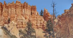
3.2 miles S of Bryce, UtahThe Queen's Garden Trail is the hike to see the wonders of Bryce Canyon's main amphitheater from all angles. Starting at Sunrise Point, you'll have a great view from the rim before the trail wraps it's way down through the hoodoos. The dirt trail is very well kept and wide with a little bit of a flowy feel. There are benches and logs along the way if you need a breather but beyond the trails edge is a steep descent, often on both sides. As you follow the trail deeper, that exposure becomes less severe but even at the top, it's only scary if you think your kids might plunge over the side. The trail offers plenty of room to stay well away from the edge.
As you descend, you'll see new details of the rocks and hoodoos as you get ever closer and begin to look up at them a little more. The trail goes right through the wall in a couple of places as well with great little tunnels cut out of the rock. Make sure to take what looks like a detour into the Queen's Garden. There's a placard there that explains the location and will help you find the Queen Victoria rock structure a little easier. It's also where you'll notice the change in ecosystem. You're now surrounded by trees and low plant growth.
The change in ecosystem continues as you head further down the trail. You're still looking up at hoodoos but you're now walking on a forest trail below them. The Queen's Garden Trail ends in the bottom of the canyon at the junction of the Navajo Loop Trail. Don't worry about taking the wrong turn as it's an "All roads lead to Rome" scenario. Whether you take the West (Left) fork or the East (Right) fork, you'll follow the Navajo Loop Trail up to Sunset Point. The East fork is much shorter and will take you to Two Bridges and up the stonebrick switchbacks. Either way, there will be plenty of hoodoos, switchbacks, and caves. Towards the top, you can take a detour on the Peekaboo Loop as well.
Durant Nature Preserve
Raleigh, North Carolina
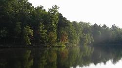
8.6 miles NE of Raleigh, North CarolinaVisiting Durant Nature Preserve is an opportunity for people in the bustling cities of Raleigh and Wake Forest to connect with nature. This nature preserve stretches over 237 acres. There are eight trails throughout the preserve that are accessible to hikers, three of which allow mountain biking.
The trails available to mountain bikers are Border Trail, on the perimeter of the preserve, White House Road and Beaver Pond Trail. The Border Trail is accessible from Campbell Lodge at the South Entrance of the preserve. White House Road is accessible from the North Entrance on Camp Durant Road. Beaver Pond Trail is accessible from the Border and White House Trails.
Secret Creek Trail is a well kept secret of the park. This trail begins to the left of the playground hidden in trees. The trail is approximately one mile out and back. It's a scenic beginner hike that is great for children. The creek that neighbors the trail provides an opportunity to see some wildlife, enjoy the calming flow of water, and splash around when it gets hot outside.
Durant Nature Preserve contains several parks, including a bird park and butterfly park, as well as a playground for children. There are several covered and uncovered picnic areas for visitors to use, some can be reserved while others are first come first served. A sand volleyball court is also available for use. The two Camp Durant lakes allow fishing year round. North Carolina fishing regulations apply.
Durant Nature Preserve has achieved a great accomplishment in providing a place for outdoor enthusiasts to escape to nature. Residents of Raleigh and Wake Forest have been given the opportunity to experience adventures or find peace in nature in this sanctuary.


