Shoshone Falls Park
Twin Falls, Idaho
| Address: | Shoshone Falls Park, Twin Falls, ID 83301, USA |
| GPS: |
42°35'37.2"N 114°24'3.5"W Maps | Directions |
| State: | Idaho |
Restrooms Picnic Tables Rivers Waterfalls Trails
Hike
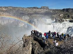
The view of Shoshone Falls is beautiful year round but it is simply breathtaking during spring runoff when the water levels are high and they roar so hard you can feel the mist hundreds of feet above the water. There are multiple platforms for viewing as well as information placards and a little gift stand. The park is owned and managed by the city of Twin Falls who charge a fee of $3 per carload (as of 4/1/2017).
The canyon rim trail goes up the canyon wall on the Southwest end of the falls and continues along the rim taking you to the site of Evel Kneival's 1974 attempt to jump the Snake River Canyon. To the jump site and back is about 2.5 miles round trip.
More Information
Be courteous, informed, and prepared. Read trailhead guidelines, stay on the trail, and don't feed the wildlife.
Read MoreDirections
From Twin Falls, Idaho
- Head northeast on Shoshone St E toward E 3900 N Rd/Addison Ave E (161 ft)
- Slight right onto E 3900 N Rd/Addison Ave E (3.0 mi)
- Turn left onto N 3300 E/Champlin RdContinue to follow Champlin Rd(2.5 mi)
- Slight left onto N 3300 E/Champlin RdDestination will be on the right(0.4 mi)
Other Hiking Trails Nearby

Perrine Bridge
Jerome, Idaho
2.7 miles WPerrine Bridge is located just above the Snake River. It spans 1,500ft, and is 486ft above the Snake River. You can drive over this bridge on the way back from Boise, or get out, park, and take...
Hike
Indian Springs
Kimberly, Idaho
12.6 miles SMulti-use trail system in south of Kimberly / Twin Falls, Idaho. Used for Mountain Biking, Hiking, and Horseback Riding.
Hike, Hot Springs, Mountain Bike
Little City of Rocks
Gooding, Idaho
39.0 miles NNot to be confused with the City of Rocks National Reserve, Little City of Rocks is located near Gooding, Idaho. There are two portions to the area, the Little City of Rocks and the Gooding City...
Camp, Hike 4.8 mi
Independence Lakes
Elba, Idaho
44.8 miles SEThe Independence Lakes hike is a 7.7 mile hike that gets progressively better the farther you go. At the summit of Mt. Independence, you will get a birds eye view of four beautiful jewel tone...
Backpack, Camp, Canoe, Hike, Kayak, Swim
Castle Rocks State Park
Almo, Idaho
48.7 miles SENeighboring the popular climbing area City of Rocks, Castle Rock is a beautiful state park with plenty to do. This park opened to the public in 2003 and offers many additional climbing and hiking...
Camp, Hike, Rock ClimbNearby Campsites

Kimama Wind Caves
Paul, Idaho
29.2 miles NEThe Kimama Wind Caves are a series of lava tubes accessed by a crack in the middle of the desert north of Paul, Idaho. These lava tubes create a labyrinth of tunnels to explore. These tunnels should...
Camp, Cave
McKinney Butte Lava Tubes
Gooding, Idaho
36.6 miles NWAlso known to the locals as the Spider Caves, the McKinney Butte Lava Tubes is a tunnel formed by lava flows from long ago. Similar to many lava tubes with an entrance broken from the side of...
Camp, Cave
Little City of Rocks
Gooding, Idaho
39.0 miles NNot to be confused with the City of Rocks National Reserve, Little City of Rocks is located near Gooding, Idaho. There are two portions to the area, the Little City of Rocks and the Gooding City...
Camp, Hike 4.8 mi
Independence Lakes
Elba, Idaho
44.8 miles SEThe Independence Lakes hike is a 7.7 mile hike that gets progressively better the farther you go. At the summit of Mt. Independence, you will get a birds eye view of four beautiful jewel tone...
Backpack, Camp, Canoe, Hike, Kayak, Swim
Castle Rocks State Park
Almo, Idaho
48.7 miles SENeighboring the popular climbing area City of Rocks, Castle Rock is a beautiful state park with plenty to do. This park opened to the public in 2003 and offers many additional climbing and hiking...
Camp, Hike, Rock Climb


