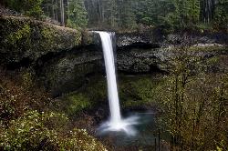
Silver Falls State Park
Sublimity, Oregon
7.6 miles NE of Sublimity, OregonSilver Falls State Park is a forested canyon that features 10 amazing waterfalls throughout the park. It is the largest state park in Oregon and one of the most popular, both nationally and internationally. People come from all over to witness the beauty of these splendid waterfalls at this unique and amazing park. It's less than an hour east of the Salem state capital in the green foothills of the Cascade Mountains.
At the South Falls, you can walk in awe behind a 177-foot waterfall. It's a part of the Trail of Ten Falls which is a breathtaking and nationally recognized hiking trail. This trail winds through lush, dense forested landscape and along a canyon where you will see many gorgeous waterfalls from different vantage points. You descend the trail following a serpentine creek to the forest floor. Photographers of all skill levels love to come to Silver Falls to capture the picturesque, scenic views it has to offer.
The full loop to hike all 10 waterfalls is about 7.2 miles and is considered a moderate hike with an elevation change of 800 feet. There are connecting trails that can make the hike shorter if one so desires. The park provides over 25 miles of backcountry trails for the outdoor enthusiast to enjoy.
Besides hiking, many visitors enjoy mountain biking, horseback riding, as well as camping at Silver Falls. The campground has tent and RV sites as well as cabins. If you bring a horse, there is a horse campground for you to stay at. There are also group tent and RV sites for larger groups and ranches that can sleep 75 people in dormitory-style bunkhouses.
The South Falls Day Use Area has open lawns, picnic tables, and shelters, barbecue stands, a playground, horseshoe pits, and an off-leash area for dogs. This area is frequently used for potlucks, family reunions, and even weddings.
(No pets are allowed on the Canyon Trail for everyone's safety. Pets on a leash can be on all other trails)
A $3-per-car fee is charged to park anywhere in the state park.
NOTE: It's important to remember that bears and cougars live in the more remote areas of the park.
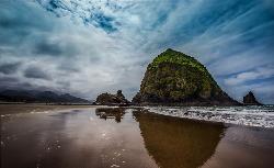
Haystack Rock
Cannon Beach, Oregon
0.6 miles SW of Cannon Beach, OregonHaystack Rock is a 235-foot (72-meter) sea stack in Cannon Beach, Oregon. It is sometimes claimed locally to be the third-tallest such "intertidal" structure in the world, but there are no official references to support this. A popular tourist destination, the monolithic rock is adjacent to the beach and accessible by foot at low tide. The Haystack Rock tide pools are home to many intertidal animals, including starfish, sea anemone, crabs, chitons, limpets, and sea slugs. The rock is also a nesting site for many sea birds, including terns and puffins.
Visitors to Haystack Rock can view many species of marine wildlife in their natural habitat during low tide. The thin strip of rock and sand that connects it to the beach at these times features many tide pools. The area surrounding the rock is popular for picnicking, kite-flying, and bird-watching. Artists and photographers can be found capturing the beauty of Haystack Rock on canvas or on film.
Courtesy of Wikipedia.com

Mount Pisgah
Eugene, Oregon
6.1 miles SE of Eugene, OregonMount Pisgah is a summit in Willamette Valley. It is a popular place for hiking, walking, and trail running because of how close it is to the city of Eugene and Springfield. The non-profit arboretum (also known as the "living tree museum") at the bottom of the summit covers 209 acres. You can also learn about different plants and wildlife along the trails because of informational signs you'll see along the way.
There are multiple hiking trails that go off of the main trail: Main Trailhead to Summit, North Trailhead to Summit, Swing Hill Trail, and Trails #3--#7. The Swing Hill Trail has two swings hanging from oak trees at the highest point of the trail.
Admission is free, but Lane County Parks requires a $4 parking fee for each vehicle.
NOTE: Don't wander off the designated trails or paths since the area has a lot of poison oak.
*Keeping dogs on a leash is strictly enforced by Mount Pisgah Arboretum.

Cape Lookout Trailhead
Cloverdale, Oregon
10.2 miles NW of Cloverdale, OregonCape Lookout State Park has multiple hiking trails. This trail is among one of the more popular ones because it leads you to the steep cliffs which provide gorgeous views of the ocean and adjacent cliffs. Cape Lookout is also one of the prime locations for whale watching. Some have even said they've seen sea lions and orcas from the capes.
This slightly downhill trail is typically muddy and can be slippery at times. There are boardwalks in some of the really bad areas.
This is a beautiful hike that goes through the lush, green, coastal forest. Sometimes the trail can be a bit crowded depending on when you go.
Elevation gain: about 400 ft
Roundtrip: about 5.0 miles
NOTE: There is a $5 fee to use Cape Lookout State Park. AND MAKE SURE TO HOLD ON TO LITTLE ONES AT THE END OF THE TRAIL SO THEY DON'T FALL OFF THE 400 FT CLIFF.
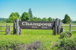
Champoeg State Park
Saint Paul, Oregon
4.9 miles NE of Saint Paul, OregonChampoeg State Park (commonly pronounced SHAM-poo-EE) is a historic pioneer site as well as a beautiful outdoor recreational area. The Native Americans originally pronounced it CHAM-po-EGG, but it can be said either way. It was originally the homeland of the Tualatin Kalapuya tribe. In 1811, fur trappers arrived by canoe and discovered open prairies and lush land next to the Willamette River. In 1830, the French-Canadians began farming and raising families with their Indian wives once they retired from the Hudson Bay Company. Champoeg became a shipping and commercial centre with steamboat landings and ferry crossings. In 1851, local tribes and U.S government established six treaties at Champoeg. A flood in 1861 destroyed the Hudson Bay Company's granary and townsite. The historical interest draws many people to this location.
At Champoeg State Park, many people enjoy camping, boating, fishing, hiking, trail running, biking, and disc golf. There is also an amphitheatre where outdoor concerts are held during the summer months. The park also has 6 yurts and 6 cabins to stay the night in. They are usually reserved in advance so try to book a stay ahead of time. There are also 79 campsites, most all of which are RV friendly. Flushing toilets and hot showers are available.
The scenery at Champoeg is fairly diverse. There are many open field areas, as well as a lot of areas that are heavily wooded with tall trees and various vegetation. The hiking/walking trails lead through the wooded areas, but also through the open fields. The trails are easy to hike with small children. Just make sure to hold their hands or watch them carefully near the steep areas.
The park is home to the oldest operating store in Oregon, the Historic Butteville Store. Back in the day, it used to be a general store. You can walk or bike ride to the store and enjoy a cold drink or ice cream bar while learning about the local history of the area.
The disc golf course has 15 baskets. There are a couple baskets which are on top of stumps making the baskets a bit more difficult. Par: 45. The playing field is open in some areas, but there are quite a few trees in other areas.
There is a boardwalk and boat access on the calm Willamette River.
Level terrain with tall, thick oaks. Good length and fair fairways. 18 long concrete tees and 11 shorter ones with multiple pin placements. We share this park with other users - please yield to picnickers, walkers and bikers. Vehicle fee; $5/day, $30/annual. Public ($3.00)Courtesy of DiscGolfUnited.com
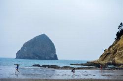
Cape Kiwanda
Pacific City, Oregon
1.3 miles NW of Pacific City, OregonCape Kiwanda is a state natural area in Pacific City, Oregon. This is a fantastic place to spend an entire afternoon! You will see magnificent views of the basalt monolith officially called, Chief Kiawanda Rock. It is commonly misnamed as the "other haystack rock" and is 90-feet higher than Haystack Rock in Cannon Beach. The basalt stack got its name from a leader for the Nestucca Indian tribe. You will also see some impressive dunes and remarkable sandstone. At low tide, you can explore the sandstone at the base of the cliffs and search for fossils. The sandstone still remains due to the protection that Chief Kiawanda rock provides against the immense waves of the ocean. The Cape Kiwanda hike begins at the Pacific Avenue trailhead which is about a mile down from the cape itself. Walking along the beach you will enjoy views of the incredible monolith and the beautiful scene of the cape ahead of you. You will probably see surfers in wetsuits and some occasional kayakers. Pacific City is one of the most popular places to surf on the Oregon Coast because of its consistency.
Once you get to the base of the dune, there are two routes you can go. The lower route, and the way up the Great Dune. If you decide to hike up the Great Dune first, you can make a loop hike out of it because you can circle around the Sitka spruce trees and make your way to the lower dune by a trail through the trees once you're at the top. The lower dune goes out to the edge of the cape and provides gorgeous views of the opposite side of Cape Kiwanda. To your right, you'll be able to see Nestucca Bay. There are fences and signs that discourage visitors from getting too close to the edge of the cape due to soft cliff edges crumbling or falling off. This can happen at any time, so it's important to be careful.
You can take the trail down the lower dune to the base of Cape Kiwanda, or you can turn back and run or slide down the Great Dune. It's a very popular sandboarding or "sand sledding" spot.
Climbing up the Great Dune is somewhat of a workout. You will definitely feel the burn in your legs halfway to the top. This climb can be done with children. but they may require some assistance due to the strenuous hiking. You won't make much progress just using your feet to walk up, so it's a bit faster and easier if you use your hands and crawl up the dune. It's difficult, but definitely worth it once you reach the top!
NOTE: One of the downsides of the Cape Kiwanda area and Pacific City is that it is typically very busy and crowded.

St. Anthony Sand Dunes
Saint Anthony, Idaho
6.0 miles NW of Saint Anthony, IdahoBest known for their offroad riding conditions, the St. Anthony Sand Dunes provide a sledding experience unlike any other. These mountains of sand are fun for sliding down in the summer but during the winter, you won't find a smoother surface for the snow. There are hills everywhere you look and it doesn't take much to find a bowl or halfpipe like experience.

North Menan Butte ('R' Mountain)
Menan, Idaho
4.5 miles N of Menan, IdahoThe North Menan Butte is more commonly known to the locals and college students as R Mountain. Many kids know it better as Ou'R' Mountain. The butte is a rare and unique geological area and provides a great volcanic hike.
There's a paved parking lot and a vault toilet at the West trailhead. The first few hundred yards are well-maintained gravel and sand paths and the further you get, the less defined the trail gets, though it is relatively easy to find and follow. The switchback trails (South and West) are marked by sections of log fences. Towards the top of the West switchbacks, there's a chain handrail. It gets a little steep so you'll want some shoes with some grip. The sand on the rock makes it pretty slippery in the steeper parts. You'll get better grip after a good rain. Once you get up to the top, there's an informational placard. From there, it's easy to hike the rim and get an awesome view of the valley including Rexburg, Henry's Fork, and the Snake River.
It's a great hike for a small family or just a quick hike for a date. Even going up the West switchbacks and around rim, including the 'R', and back down the same way is only 3.5 miles (longest route) so you can do it pretty quick if you want. There's so much to look at that you could also spend hours climbing rocks, exploring caves, and playing around "The Ampitheater". If you just want to get to the 'R' as quickly as possible, you can do the hike in as little as 2 miles roundtrip.
Distances:
- West trailhead up the face to the rim: 0.5 miles
- West trailhead up the switchbacks to the rim: 0.75 miles
- West trailhead, from reaching the rim to 'R': 1 mile
- South trailhead to the rim: 0.3 miles
- South trailhead, from reaching the rim to 'R': 0.75 mile
- Through the caldera: 0.6 miles
- Around the rim: 2 miles
- Rim to 'R': 500 feet
There are no fees. Camping is allowed up to 5 nights but fires must be in an elevated fire pan and all the ash must be packed out.
Posted regulations:
- No motorized vehicle use
- Discharging of weapons or fireworks is prohibited
- Open fires are permitted only with an approved elevated fire pan and ash removal
- Burning pallets, tires, wire, plastic, glass, metal, magnesium, or hazardous material is prohibited
- Cutting or damaging vegitation is prohibited
- 5-day camping limit
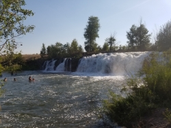
Monkey Rock
Saint Anthony, Idaho
4.1 miles SE of Saint Anthony, IdahoMonkey Rock features a beautiful waterfall you can wade right up to during the summer. Just under the waterfall is a great spot to wade around in or even some shallow swimming pretty good for small children. Maybe you just want to take advantage of the great bank to bask in the summer sun. The water temperature is fairly cool, which by no means is unwelcomed during the hot summer months. You'll get used to the water fairly quickly once you're in. The waterfall is a fun feature at Monkey Rock, not to mention a popular engagement photo backdrop. The name "Monkey Rock" is derived from the "monkeys" who jump off the rocks at the top of the falls to the pool below. Though not a great height, it's important to be careful and only jump into areas clear of rocks and other hazards and where the water is deep enough that you won't hit bottom when you jump. There really isn't a safe spot to jump from the falls as it doesn't usually get more than 5 feet deep.
The real jumping location is off the Hog Hollow Bridge up the road from the waterfall.
PLEASE NOTE: On the roads leading to Monkey Rock, the speed limit is 35 mph for the last mile. There are kids, cows, horses, and dogs along that road and many people tend to speed going to and from Monkey Rock. Please slow down and stay safe.


