947 Calming Hikes by jamiegarrard
first prev 1 next lastThese hikes are peaceful. They are hikes that are a little more simple, but help lift your spirits if you're a little stressed or anxious. Take the time to enjoy yourself on these hikes.
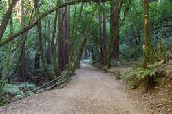
East Ridge Trail
Oakland, California
6.9 miles E of Oakland, CaliforniaThis trail is deeply tucked away up into the hills of Oakland. East Ridge is the perfect trail to deeply appreciate the beauty of the Redwoods and has many entry points. This trail weaves through grassy meadows and over ridges and steep slopes. This trail has shady parts and will lead you to the falls.
This trail on this hike is wide, even and gentle. This hike is accessible to all hikers that want to enjoy it. This trail winds steeply down to the valley floor and after rain, can be very slippery. Hikers that hike at a normal, relaxed pace, can complete this loop in about 2-3 hours. If speed is your thing, trails are equally ideal for trail running.
This hike is accessible all year round. This trail is exposed and can be pretty hot and dusty in the summer. During the rainy seasons, trails can be slippery and muddy after rain. During the winter season, keep your eye out for the massive clusters of ladybugs that migrate to the park’s trees each winter along the park’s coast redwoods.
Dogs must be leashed if you take them on this hike. The main entrance, Redwood Gate, charges a $5 parking fee during peak season. The park is opens at 5am and closes at 10pm. So if you like hiking or running at the crack-of-dawn or would prefer going after work, you can enjoy the trail and facilities.
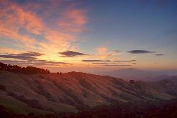
Grizzly Peak Trail
Berkeley, California
2.1 miles NE of Berkeley, CaliforniaGrizzly Peak Trail is located near La Loma Park in the Berkeley Hills section of the city of Berkeley, California and leads to an incredible lookout of the San Francisco Bay area. Driving up Grizzly Peak Road there are many spectacular places to pull over to take photos. This is a great hike to take out-of-town guests or tourists to go on, and it can be done on the way to or from Oakland/Berkeley.
Many runners have said that this trail is great for running and that the peak is a great place to stop and enjoy the view. If you choose to run to the peak and back, it would be about a 1-mile run, roundtrip. If you want to run the whole trail, it would be a little over 2 miles. This trail is dog-friendly, however, you should keep your dog on a leash. This hike is the best and most beautiful when done on a clear day, so be sure to check the weather the day before your hike.
The peak can be climbed almost year round because its elevation is relatively low. During periods of recent snowfall, it may be best to avoid the peak because of the ice and snow. Snow doesn't last too long on the peak, usually melting off most of the routes within a few days of snow. In the height of summer, temperatures may be too warm for an enjoyable climb.
The peak was named because of the Grizzly bears inhabiting the area until the late 1880s. The last grizzly in all of California was killed in the Sierra foothills east of Fresno in August 1922.
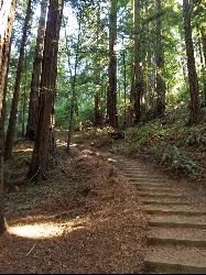
Muir Woods National Monument
Mill Valley, California
1.9 miles W of Mill Valley, CaliforniaThere are several suggested hikes on the main trail leaving from the visitors center. The longest, a loop, is about 2 miles. It is the only one that leaves the boardwalk. It has some elevation gain. The others areally flat, with a boardwalk taking you to trees with signs explaining their significance. There is a lot of information posted around to inform curious minds, as well as some guided tours and programs from children. There are several other trails leaving or passing through this area, for those looking for a longer hike.

Quarry Trail
Cool, California
2.0 miles N of Cool, CaliforniaThis is a hike along the river and an old, historic railway. The trail leads you to a a beautiful amphitheater carved from limestone.You are surrounded by beautiful nature and peaceful noises. The trail is wide and you can take your time to take in all the beauty. The only part that is a little more difficult is the last stretch up to the quarry.
The railway that you will see used to carry out limestone and was taken 7 miles to Auburn for cement productions. Each train was filled about four times a day. In 1942, the metal from the old railway was used as scrap metal during WWII.
There are some places on the trail that aren't clearly marked, especially when you get to the quarry. Stay wary of where you are and keep an eye out for signs that will guide you to where you need to go. The trail is great all year around, but between April and June, the wildflowers are the most beautiful.
KEEP IN MIND: California does charge $10 as a day-use fee for each car going into the parking area, although prices are subject to change. Dogs are allowed if they are leashed. There are no bikes allowed on this hike.

Burney Falls
Burney, California
9.2 miles N of Burney, CaliforniaBurney Falls has been considered one of the most spectacular waterfalls in the state. It stands at 129 feet tall and is coated by curtains of green fern. The best part about this waterfall, for many hikers and Californians is that it flows year-round. This is one of the very few waterfalls in California that has good water flow throughout the year. The waterfall is loud, but can also be pretty remarkable in how peaceful it can feel.
The main attraction, can be accessed directly from the parking area or through many different trails which lead to higher or lower views of the falls. Each angle is beautiful in their unique ways. The best time of the day to go is earlier in the morning and a little before sunset. If you go in the middle of the day, it could get crowded. Â
The water temperature never rises over 42 degrees Fahrenheit, but the fisherman never seem to mind because of the great fishing that happens. The fishing that takes place is catch-and-release fly fishing.Â
There is an $8 day-parking fee at this park. Do not park on the street near the entrance of the park, because your car could be subjected to citations or be towed.Â
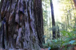
Lady Bird Johnson Grove Trail
Orick, California
2.5 miles NE of Orick, CaliforniaThis is a short hike that surrounds you with greenery and beautiful, tall trees. As you hike through the grove, you may hear birds chirping, but you will mostly just hear your feet walking on the dirt trail. It is a quiet, peaceful place to go to escape the day-to-day noise.
For a major redwood attraction, this trail is, unusually, at 1200 feet above sea level. This ridgeside grove is spectacular because it is much more than shrubs and trees.The trees are very tall and the greenery that surrounds you is brilliant. This grove is free of noise from the city traffic because of it's elevation. It is often in the clouds and gets a lot more fog than lowland groves.
History of Location: President Richard Nixon, in August 1969, dedicated the grove to Lady Bird Johnson who was an environmental activist, women's right activist, as well as former first lady. Richard Nixon named the grave after Mrs. Johnson because of the beautiful works she accomplished in her life and how the grove echoed that sentiment.
This is a free attraction, about a mile and a half, round-trip, surrounded by lots of parking, and a visual trail guide is available for purchase, for a dollar.

Natural Bridges State Park / Monarch Butterfly Trail
Santa Cruz, California
2.0 miles SW of Santa Cruz, CaliforniaThis trail is perfectly tucked away from the business of Santa Cruz. Monarch butterflies, during the Winter, fly here to stay warm. As you walk through the Monarch Grove, you will see trees covered with butterflies. Their wings fluttering look like tree leaves blowing in the wind, until you take a closer look. It is a peaceful place to be as you learn about Monarch butterflies and watch them fly around.
Monarch butterfly migration begins at different times but they start arriving in the grove around mid-October. This is the perfect time of year to take a nice stroll on the boardwalk and watch the butterflies. The park is filled with eucalyptus trees which give the butterflies the perfect protection for them in the winter months. Since this is a preserve, it is asked not to grab or hold butterflies and to stay quiet to help continue making them feel safe. The end of the Monarch season is around mid-February. It is the perfect, family friendly location.
There is one main trail, but you can customize the length of your walk/hike depending on what you would like to do.
The trail leads to a beautiful sandy beach. You will see a huge, beautiful rock arch to your left of the beach. The water is refreshingly cool. Watching the sunset over the water, pulls out the orange colors of the arch rock making the scene bright and peaceful.
This is the perfect location to see shore birds, migrating whales, and playing otters offshore. As you continue to walk around the beach, you will come across tide pools where you can get a glimpse of sea life. The low tide allows visitors to see star fish and other sea animals. It is a great location for families to explore and enjoy their time together.
Important Information: There is a $10 vehicle day-use fee. The water is shallow enough for children to play safely, but it is necessary for parents to supervise their children because there aren't lifeguards on duty. Bikes are permitted on the paved roads around the park and beach. Dogs are also permitted on paved roads and in the park but not on the beach.
Palomarin Trail
Bolinas, California
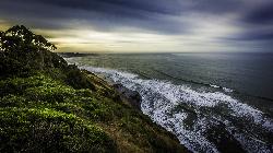
3.7 miles NW of Bolinas, CaliforniaThis hike is about 5 miles north from Bolinas is the Palomarin Trailhead. As you hike the trail you overlook the ocean and beautiful beaches. The trail takes you up to different lakes and then ends at the beautiful Alamere Falls. Enjoy the stunning views of the pacific combined with varying terrain through forests, tall brush, and exposed dirt trails.
If you hike to falls during the summer, something great to do on your way back to the trailhead is to take a swim in Bass Lake. When you reach the path near the coast, it gets more narrow and steep. You'll often notice a little traffic jam as people figure out how to navigate their way down.
There are two steep parts when you're heading to the coast. The first steep path leads you just above the main part of the falls where you will see smaller waterfalls and the second leads you to the beach. If there are other people on the path with you, just leave room between you and them when you're headed down to the beach, just to ensure safety.
This is not a dog friendly path.
KEEP IN MIND: When you reach beach to the falls, remember that the park staff would prefer that visitors do not go to Alamere Falls itslef; it is advised that you view the falls from the beach. However, there is a "path" to the falls that is well known and can be navigated safely to get to the falls. Just remember to proceed with caution.
Trail of the Cedars
Apgar Village, Glacier National Park
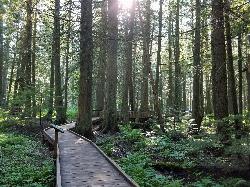
13.2 miles NE of Apgar Village, Glacier National ParkThe Trail of the Cedars is one of the most popular hikes in the park because of it offers great views without too much exertion. It is a short loop hike around Avalanche Creek in Glacier National Park. The hike is a fairly easy walk through a cedar tree forest and offers gorgeous views of Avalanche Creek which now cascades downstream as glacially melted water. The trees in this forest are some of the tallest and the oldest in the park, reaching up to 100 feet tall and 4 to 7 feet across at around 500 years old. This area has survived fires and avalanches for years, allowing it to flourish. The trail is wheelchair accessible and leads to a footbridge at the creek.
Just past the Avalanche Lake trail junction is an even closer view of the creek and the trailhead to Avalanche Lake, which is another 1.6 miles for those feeling a little more adventurous.
After passing Avalanche Creek, the trail reaches past the Avalanche Creek Campground and loops back out to the road. Parking can get difficult here because it is such a popular hike and there are limited spaces. The trailhead is about 5 and a half miles from Lake McDonald Lodge, along Going to the Sun Road.

Glen Alpine Falls
South Lake Tahoe, California
6.6 miles SW of South Lake Tahoe, CaliforniaAs you drive up to the falls, take a look around. The views are spectacular. The drive can feel long, but the waterfall is peaceful and worth the drive. This waterfall is considered one of the shorter waterfalls around but it is wider. It is a peaceful location because of the sounds of birds chirping and the water flowing.
The best time to come to the waterfall is the middle of spring (June) all the way until the end of summer (August). That is when the water flow is the strongest and the most beautiful.
Something to keep in mind, there is no real trail to the falls, just because you can park right near it. But there are many places to park alongside the road, and you can walk up that road to the falls. There is an overlook point that you can sit at and watch the water flow down. If you are more adventurous, you can climb down the rocks to the water below.
Be sure to check it out when you are in or near Lake Tahoe.
Fern Canyon
Orick, California
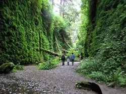
7.9 miles N of Orick, CaliforniaFern Canyon is one of the best 1-mile hikes that you can do in California! This unforgettable location was featured in Steven Spielberg's film, Jurassic Park: The Lost World.
Fern Canyon is located in Prairie Creek Redwoods. It's not incredibly easy to find, but the remote 8-mile drive will be worth seeing this fern laden paradise. Two stream crossings will need to be done by car, but one of these streams can be about 6 inches deep. If you don't think your car can make it, you'll just have to park and walk an extra mile.
Since this drive is pretty much in the middle of nowhere, you may see a lot of wildlife. You will most likely see a lot of elk on this drive so it's important to drive slowly on the dirt road. Also be aware of potholes along the road.
The drive is the most difficult part of this trip, so the hike is going to be a piece of cake in comparison. There is a parking lot with a vault toilet and a sign giving information about the area. The level trail begins at the top of the parking lot and leads you through a small, moss-covered forest before you reach the canyon. Be prepared to get wet during your hike because you will have to cross more streams. Don't try to find a way around the water and just have fun with it. Since the trail is relatively flat, this hike is a perfect, fun adventure for those with small children. There are a few wooden foot bridges here and there to cross some of the streams, but it is probable you will get your feet wet at some point.
Once you reach the canyon, you will have 50-foot canyon walls towering over you. These walls have lush, green plants cascading down the sides and there are fallen redwood trees, green with moss. You will possibly have to climb over or under a few logs. Along the canyon walls, there are some little waterfalls and streams that trickle down through the foliage. You will feel as if you are walking through a rainforest in Fern Canyon. No wonder a scene from the Jurassic Park movie was filmed here!
Going through the canyon itself is only about a half a mile, but the trail continues on and flattens out again into a forest. You can hike the whole loop trail or you can go back the way you came if you want to experience the canyon again (who wouldn't?).
Make sure you add this magical place to your list of places to see!
NOTE: Leave early in the morning to avoid the crowds. Bring water shoes or sandals.

Garden of Eden
Felton, California
2.0 miles SE of Felton, CaliforniaA great swimming hole in the Santa Cruz moutains of California, the Garden of Eden lives up to its name. This swimming hole is popular among all ages and offers beaches perfect for sunbathing and some nice cliffs perfect for jumping into the blue pool below. Be sure to pack out all garabage, and know that campfires are not allowed in this area. There are multiple pools at the Garden of Eden, offering a swimming spot for everyone. Sometimes this spot is mistaken for Big Rock Hole which is another swimming hole further down the river.


