


33 Things to do near Mee Canyon Alcove
first prev 1 2 next lastShowing results within 50 miles Distance miles of Unnamed Road, Mack, CO 81525, USA City, Zip, or Address
Kokopelli Trail
Cisco, Utah
8.9 miles WThis trail was named after Kokopelli,the ancient god of fertility. The hump-back flute player, is a symbol seen all over the southwest. Kokopelli's Trail starts in Loma and goes all the...
Mountain Bike
Westwater Mesa / Overlook
Thompson, Utah
10.3 miles WScenic trails that mostly follow the Colorado River canyon rim. Singletrack is used by motorcycles, but is surprisingly solid. There are a few junctions along the way that can be...
Mountain Bike
Fruita Riverfront Park Disc Golf Course
Fruita, Colorado
10.8 miles ERocky riverbed - desert terrain. Elevation, arroyos, trees and shrubs. A variety of long and short holes, tunnel shots and unique holes. with super views of the Colorado River, CO National Monument...
Disc Golf
Little Salt Wash Park
Fruita, Colorado
12.6 miles EOn natural terrain - short, tight and technical, weaving in and out of cottonwood, willow, Russian olive and tamarisk trees as it meanders along Little Salt Wash. Errant throws not forgiven. Added...
Disc Golf
Andy's Tunnel
Grand Junction, Colorado
20.7 miles SEAndy's tunnel is a cool place to retreat while hiking in the area. it is probably about 50 feet long and most of it is big walking pasage
Cave, Hike
Westlake Park
Grand Junction, Colorado
20.9 miles EAll but 5 baskets have been pulled (1,2,3,8 and 9). Public (No Fee)
Disc Golf
Watson Island DIsc Golf Course
Grand Junction, Colorado
22.3 miles ERight beside the Botanical Gardens. Surrounded by water. Bring map to help navigate. Public (No Fee)
Disc Golf
Matchett Park
Grand Junction, Colorado
25.0 miles EOpen dirt course with elevation, cliffs, and thick brush surrounding creek. Difficult to play when muddy. Public (No Fee)
Disc Golf
Top Of The World
Cisco, Utah
30.5 miles SWThis is a 4x4 trail that is a load of fun. It is not that steep but there are lots of bike steps that you have to climb (and get to descend!). The view at the top is unbelievable....
Mountain Bike
Little Creek/ Corral Fork
32.2 miles S
Doesn’t look like this world class singletrack gets ridden much. Little Creek was overgrown and difficult to follow in a few places. Ride up Little Creak about 1 mile...
Mountain Bike
Riverbend Park
Palisade, Colorado
32.2 miles EChallenging - in a beautiful and secluded location. Plays through cottonwoods along the Colorado River. Multiple pin positions. Dual tees on 11 holes. Water hazards with mosquitoes - bring...
Disc Golf
Gateway Canyons Resort Disc Golf
Gateway, Colorado
33.2 miles SIn Cottonwood gallery, near the Dolores River. Challenging with good variety. Private (No Fee)
Disc Golf
Island Acres
Palisade, Colorado
35.0 miles EColorado River S. P. - Island Acres Section - Swimming place with sandy beach at state park. RESERVE AMERICA WEB SITE. Fees: Yes
Swim
Dominguez Canyon
Aspen, Colorado
37.9 miles SEMultiple swimming holes along an 6-8 mile minimum (round trip) hike in the Dominguez Canyon of the Gunnison River and joining the canyons of Little Dominguez Creek and Big Dominguez...
Swim
Arches NP Main Road
Moab, Utah
43.2 miles SWThis is the main road through Arches National Park. Road is paved (chipseal). Most people drive through, but this makes a beautiful cycle ride. As with any riding in Moab, you must...
Mountain Bike
Powderhorn Mountain Resort
Mesa, Colorado
43.7 miles EPlays mostly open with lots of elevation in play up and down the ski runs. Open to the public free of charge. Seasonal course. Redesigned in 2012. New owners in 2015 who did not reinstall the course...
Disc Golf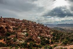
Fiery Furnace
Moab, Utah
43.8 miles SWA fun place to go hiking within Arches National Park. The Fiery Furnace area is a permit only area, with several ranger-led tours available. Hiking permits are required in order to enter, as well...
Hike
The Whole Enchilada
Moab, Utah
46.3 miles SWThis trail encompasses several trails including Burro Pass, Hazard County, and Porcupine Rim. You start out at 10000ft, and climb about another 1400 to Burro Pass, then the downhill...
Mountain Bike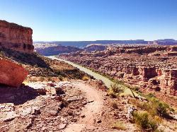
Porcupine Rim
Moab, Utah
47.0 miles SWA great mountain biking trail, Porcupine Rim takes bikers through some of the beautiful areas of Moab. The trail is also one of the most difficult and dangerous trails in the Moab area. There can...
Mountain Bike
UPS And LPS
Moab, Utah
47.0 miles SWFollow Kokopelli for about 2 miles. 2-track road gets rocky, loose and rutted out in areas, but contains fun jumps and fast action. There are a couple of short climbs. Stay on trail...
Mountain Bike


