


243 Things to do near Falls River, Lower Run
first prev 1 2 3 4 5 6 7 8 9 10 next lastShowing results within 50 miles Distance miles of 1293 4525 E, Ashton, ID 83420, USA City, Zip, or Address

Porcupine Creek
Ashton, Idaho
1.9 miles NEPorcupine Creek is a hunting, fishing, camping, and swimming spot near Ashton, Idaho in Fremont County within Targhee National Forest. It's surrounded by forests, meadows, and a creek...
Camp, Swim
Warm River Campground
Ashton, Idaho
4.8 miles NWWarm River Campground is located nine miles northeast of Ashton, Idaho, along the slow-moving Warm River at an elevation of 5,200 feet. Willows line the riverbanks and pine trees offer partial...
Camp 3.2-47.0 mi
Yellowstone Branch Line Trail
Ashton, Idaho
4.9 miles NWYellowstone branch line trail runs from Warm River to the Montana border totaling 39 miles. There are a few places to jump on and off the trail as well as a few smaller trails that branch off of this...
Backpack, Cross-country Ski, Hike, Horseback, Mountain Bike 0.3-0.6 mi
Bear Gulch
Ashton, Idaho
6.1 miles NBear Gulch is an abandoned ski hill out of operation since 1969. While the vegetation is beginning to take over, there's still some great sledding to be had. It's just far enough into the...
Camp, Cross-country Ski, Hike, Sled
The Pit
Ashton, Idaho
6.4 miles NThis location is great because there is no one around only locals know of this area and you can shoot anything out there. Watch out for target shooters there! Also stay away from the main road.
Airsoft, Paintball 0.8 mi
Conant Creek Pegram Truss Railroad Bridge
Ashton, Idaho
6.7 miles SWAs part of the Rails to Trails project, this old railroad bridge has been transformed into a very safe little viewing experience for the whole family. You can drive right up to the bridge where there...
Hike
Sheep Falls on Fall River
Ashton, Idaho
7.7 miles EThe lesser known Sheep Falls on Fall River is a local treasure off of Cave Falls road. There are primitive campsites and beautiful views for a great picnic spot. The water splits and comes down in...
Camp
Bitch Creek Trestle
Tetonia, Idaho
9.2 miles SEAs part of the Rails to Trails project, this old railroad bridge has been transformed into a very safe little viewing experience for the whole family. You can drive right up to the bridge where...
Hike
Mesa Falls
Ashton, Idaho
9.3 miles NWUpper Mesa Falls, aka Big Falls, is an absolutely awesome waterfall on the Henrys Fork of the Snake River. The falls drop 114 ft. and measure 300 ft. across. To get to the falls from the parking lot...
Cross-country Ski, Hike, Kayak 29.6 mi
Ashton to Tetonia Trail
Ashton, Idaho
9.4 miles WThe Idaho Department of Parks and Recreation undertook the project to transform the old Teton Valley Branch of the Union Pacific Railroad from Ashton to Tetonia into a trail for bikes, ATVs, and...
Mountain Bike
Horseshoe Lake
Ashton, Idaho
9.7 miles NEHorseshoe Lake is hidden back in the Targhee National Forest. It's a beautiful lake with plenty of lily pads. The road to get there is well maintained and there are many options for pull-outs...
Camp, Canoe, Dive, Swim 14.8-30.2 mi
Mr. Bubbles Hot Spring
Old Faithful, Yellowstone National Park
11.4 miles NEMr. Bubbles is one of the few places you can actually soak in the thermal waters of Yellowstone National Park. The Bechler area of Yellowstone is one of the best kept secrets of the otherwise densely...
Hike, Hot Springs
Sheep Falls on Henry's Fork
Island Park, Idaho
11.9 miles NWSheep Falls cascades approximately 25' through a narrow basalt chute on the North Fork of the Snake River near Island Park, Idaho. Compared to nearby Lower and Upper Mesa Falls, that height may...
Hike 17.5 mi
Tear Drop Lake
Ashton, Idaho
12.3 miles NENestled in the Targhee National Forest just off of Ashton's Fish Creek Road, this tear drop shaped lake is a family adventure waiting to happen. The lake isn't very big but it is teeming with...
Camp, Canoe, Hike, Kayak, Mountain Bike, Swim
Ashton Hill
Ashton, Idaho
12.7 miles NWFairly thick forest. Considerable underbrush. Lots of places in the area to play.
Airsoft, Paintball
Flat Canyon Trail
Island Park, Idaho
12.9 miles NNon-motorized use. souce: fs.usda.gov
Mountain Bike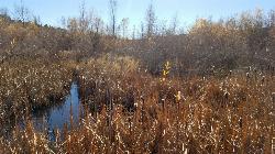
River Rush
Ashton, Idaho
13.1 miles WPaintball near Ashton, Idaho
Paintball
Cave Falls of Yellowstone
Ashton, Idaho
13.3 miles NEThis campgrond is situated on the banks of Fall River in Wyoming along the south border of Yellowstone National Park. Cave Falls Campground has 23 single site units and a terrific area for...
Camp, Hike
Badger Creek
Tetonia, Idaho
15.0 miles SBadger Creek is a stream located just 13.6 miles from Ashton, in Teton County, in the state of Idaho, United States, near France, ID. Whether you’re spinning, baitcasting or fly fishing your...
Camp, Cross-country Ski, Hike, Mountain Bike, Rock Climb
Loon Lake
Ashton, Idaho
15.0 miles ECamp, Kayak, and Swim near Ashton, Idaho
Camp, Kayak, Swim


