


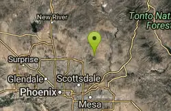
Map of 6 Free Rock Climbing Walls near Tonto Basin, Arizona
first prev 1 next lastShowing Rock Climbing Walls within 50 miles Distance miles of Tonto Basin, AZ 85553, USA City, Zip, or Address
Marcus Landslide Trail
Scottsdale, Arizona
30.2 miles WThe Marcus Landslide Trail is named after ASU professor Melvin Marcus, a renouned geographer, after the discovery and recognition of the interesting geographical area in 2002. More than 500,000...
Hike, Horseback, Mountain Bike, Rock Climb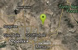
Tom's Thumb Trail
Scottsdale, Arizona
30.2 miles WTom's Thumb Trail is a popular trail on the McDowell Sonoran Preserve due to its unique thumb-like granite rock formation. This is a 4.7 out-and-back, intermediate trail because of its 1,200...
Hike, Mountain Bike, Rock Climb
Pinnacle Peak Trail
Scottsdale, Arizona
32.7 miles WPinnacle Peak is a 3.5 mile out-and-back, moderate hiking trail, that includes rock climbing routes (for experienced climbers), within the Sonoran Desert. This trail, and park, in...
Hike, Horseback, Rock Climb

Scarlett Canyon
Phoenix, Arizona
43.5 miles WScarlett Canyon trail (not officially named) is an unmarked trail adjacent to the Scarlett Canyon residential neighborhood. This is a 3 mile loop trail considered to be easy to...
Hike, Horseback, Mountain Bike, Rock Climb 1.0-1.2 mi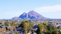
Camelback Mountain
Phoenix, Arizona
44.5 miles SWHiking After Camelback became a park in 1968, TripAdvisor advertised the hikes as one of the top 10 things to do when in Phoenix. Located right in the middle of Phoenix, Scottsdale and...
Hike, Rock Climb 0.6-2.9 mi
Tramway Trail No. 32
Happy Jack, Arizona
49.3 miles NTramway Trail is a very short but very steep hike down the ridge of the Colorado Plateau to the nearby West Clear Creek. The trail crosses over the sharp edge of the Mogollan Rim, and descends to the...
Hike, Rock Climb, Swim


