Pebble Beach
Mesa, Arizona
| Address: | N Bush Hwy, Arizona, USA |
| GPS: |
33°33'11.5"N 111°34'23.6"W Maps | Directions |
| State: | Arizona |
Restrooms Picnic Tables Rivers
Swim
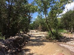
Pebble Beach is a popular place to go tubing and swimming with designated picnic areas. It's located along the Salt River in Cibola National Forest. The reason the Salt River is so salty is actually due to a type of tree that grows along the river's edge. The Salt Cedar or the Tamarix tree wasn't native to the area until it was introduced to prevent the river bank from eroding as well as catching the top soil from nearby farming regions. The doesn't produce salt but rather draws salt from the soil underground. As the wind blows and the leaves fall from the Tamarix trees, salt is dispersed throughout the land. Since these trees border the river, it makes the entire river salty.
More Information
Directions
From Mesa, Arizona
- Head north on N Center St toward W Main St (1.4 mi)
- Turn left onto W Brown Rd (0.5 mi)
- Turn right onto N Country Club Dr (1.4 mi)
- Turn right to merge onto AZ-202 Loop E (9.4 mi)
- Take exit 23A for Power Rd (0.5 mi)
- Turn left onto N Power Rd (1.9 mi)
- Continue onto N Bush Hwy (8.0 mi)
- Turn right (0.1 mi)
- Turn right (138 ft)
- Turn right (131 ft)

Other Swimming Holes Nearby
Nearby Campsites

Lower Salt River Nature Trail
Fort McDowell, Arizona
5.1 miles WThe Lower Salt River Nature Trail is a scenic walk to take at the Tonto National Forest. This trail provides stunning views as you walk alongside the Salt River. This rustic trail is older and less...
Camp, Hike
Buckhorn Campground Nature Trail
Apache Junction, Arizona
6.1 miles SWCamp and Hike near Apache Junction, Arizona
Camp, Hike


