


85 Mountain Bike Trails near St. Anthony Sand Dunes
first prev 1 2 3 4 5 next lastShowing Mountain Bike Trails within 50 miles Distance miles of 800 N 1900 E, St Anthony, ID 83445, USA City, Zip, or Address

Eagle Park
Rexburg, Idaho
12.2 miles SEagle Park is a little urban oasis. Once you drive in to this cottonwood forest along the river, you may forget that you're still inside Rexburg city limits. You can camp, picnic, throw rocks in...
Camp, Hike, Mountain Bike, Sled 0.4-0.7 mi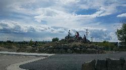
Rexburg Bike Park
Rexburg, Idaho
12.4 miles SIt's a small but great bike park for all ages; if you are a beginner, then this is the bike park to go to. The mounts are a decent size and approximately 4-6 mounts in different sizes for the...
Mountain Bike, Sled 0.1-2.3 mi
Hidden Valley Trails
Rexburg, Idaho
13.2 miles SRight on the edges of town outside of the Hidden Valley subdivision, you'll find this fun little set of trails that's pretty good for mountain bikes. It is mostly a dirt bike...
Hike, Mountain Bike 29.6 mi

Ashton to Tetonia Trail
Ashton, Idaho
17.8 miles EThe Idaho Department of Parks and Recreation undertook the project to transform the old Teton Valley Branch of the Union Pacific Railroad from Ashton to Tetonia into a trail for bikes, ATVs, and...
Mountain Bike
Big Bend Ridge Trail
Ashton, Idaho
19.8 miles NETrail is open to OHVs. source: fs.usda.gov
Mountain Bike 0.5-3.5 mi
Webster's Dam
Ririe, Idaho
23.7 miles SAlso known as Manmade Falls or the Woodmansee Dam, Webster Dam is an abandoned dam located deep in Moody Creek canyon, the dam was abandoned when sediment built up behind the dam which then...
Camp, Hike, Mountain Bike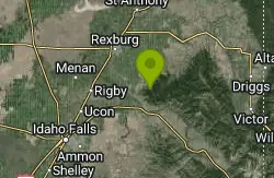
Cranky Cowboy
Herbert, Idaho
24.6 miles SMountain Bike near Herbert, Idaho
Mountain Bike 3.2-47.0 mi
Yellowstone Branch Line Trail
Ashton, Idaho
24.6 miles EYellowstone branch line trail runs from Warm River to the Montana border totaling 39 miles. There are a few places to jump on and off the trail as well as a few smaller trails that branch off of this...
Backpack, Cross-country Ski, Hike, Horseback, Mountain Bike 0.2-3.0 mi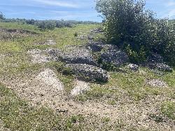
Biting Goat Trail
Ririe, Idaho
25.2 miles SPreviously known as The Cowboy Trail or the Old Cowboy Trail The Cowboy Trail is an older trail system that began revival in 2022 by Jared Klingonsmith. In 2024, it received approval to be...
Mountain Bike
Wright Creek Trail
Tetonia, Idaho
25.3 miles SEOpen to MTB, horseback riding, snowshoeing, and hiking. source: fs.usda.gov
Mountain Bike 2.1 mi
Batman
Ririe, Idaho
25.9 miles SThis trail features rolling terrain, and multiple short, steep downhill sections followed by short steep uphill sections. This trail follows the fence line. Watch out for cows (and cow droppings)...
Mountain Bike 1.7 mi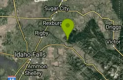
Randy's Cow Trail / Ken's Corner
Ririe, Idaho
26.0 miles SThis trail descends from the fence corner at the West end of Batman and continues down to Lyon's Creek Parking just off Lyon's road. The top of this trail is only a couple hundred yards from...
Mountain Bike
Kelly Canyon Loops
Ririe, Idaho
26.1 miles SThis mountain bike trail near Kelly Canyon Ski Area has several options available. Highlights are the views in all directions from the top of the mountain. Trails: Waterfall...
Mountain Bike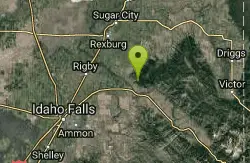
Kelly Canyon
Ririe, Idaho
26.5 miles SThe trail switchbacks up Kelly Mountain, hitting two brief red-line climbs before you get up on the top. The famed "Shale Chute" is back there somewhere (so this is part of the route for...
Mountain Bike 11.9 mi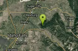
Waterfall Loop
Ririe, Idaho
26.6 miles STrail is a mixture of single track, forest road and double track. Provides a variety of scenery. About 1400 feet of elevation change throughout the trail.GPS is a must unless you are going with...
Mountain Bike 0.6-2.2 mi
Fish Creek Area
Ririe, Idaho
26.6 miles SECLOSED. This land is owned and managed by the US Forest Service and is not designated for use. As of July 2024, being caught mountain biking on this trail could recieve up to a $5000 fine and a...
Hike, Mountain Bike 0.6-4.7 mi
Harriman State Park
Island Park, Idaho
26.7 miles NEHarriman State Park is found 38 miles from Yellowstone along Henry's Fork. This 11,000-acre wildlife refuge is open year round for most activities. In addition to having beautiful scenery and...
Cross-country Ski, Hike, Horseback, Mountain Bike, Snowshoe 1.6 mi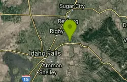
Skyline
Ririe, Idaho
27.1 miles SPunchy climb out of Little Kelly Canyon. Great vistas along a narrow traverse. Fast and loose downhill. A mix of narrow singletrack and old motorized trail.
Mountain Bike 1.7 mi
Buckskin Morgan Ridge
Ririe, Idaho
27.1 miles SCLOSED. This land is owned and managed by the US Forest Service and is not designated for use. As of July 2024, being caught mountain biking on this trail could recieve up to a $5000 fine and a...
Hike, Mountain Bike 5.7-8.1 mi
Space Cruz
Ririe, Idaho
27.1 miles SCLOSED. This land is owned and managed by the US Forest Service and the upper portions of this route are not designated for use. As of July 2024, being caught mountain biking on PINE LOOP or THE...
Cross-country Ski, Mountain Bike


