


14 Mountain Bike Trails near Horton Springs
Showing Mountain Bike Trails within 50 miles Distance miles of Horton Creek Trailhead, Nf-289, Payson, AZ 85541, USA City, Zip, or Address
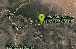
Sinkhole Campground
Payson, Arizona
12.2 miles ESinkhole Campground is a camping area near Willow Springs Lake. There are also hikes, mountain biking trails, and fishing opportunities nearby. There are 26 campsites in total at this...
Camp, Hike, Mountain Bike
Bearfoot Trail
Strawberry, Arizona
22.6 miles WHike and Mountain Bike near Strawberry, Arizona
Hike, Mountain Bike
Slate Creek Divide Loop
Phoenix, Arizona
33.9 miles SWVarious routes available - Alternative #1 (From above): 13 Mi. (22 km) Alternative #2 (From above): 10 Mi. (16 km) Loop top half only (Inc. dirt. to 8 from SR 87): 12 Mi. (19 km) Figure eight: 16 Mi....
Mountain Bike
Park Trail #66
Tonto Basin, Arizona
35.5 miles SWFrom the Park Creek Trailhead, the trail crosses Park Creek and climbs gradually through lower Sonoran Desert and riparian vegetation for ½ mile. The trail then ascends steeply...
Mountain Bike
Arizona Trail: Gooseberry Springs to Blueridge
Happy Jack, Arizona
38.5 miles NWFollow single track south. Trail made up of single track, old 2-tracks, and dirt roads. Make sure to be on the look out for AZ Trail markers. Can take trail to Highway 87 at Blue...
Mountain Bike
Sycamore Trail #68
Tonto Basin, Arizona
39.8 miles SFrom FR 421, the trail climbs steadily through lower Sonoran Desert and riparian vegetation up the arroyo formed by Sycamore Creek. It turns northward and continues to climb along a...
Mountain Bike 5.4 mi
Denton Trail #69
Tonto Basin, Arizona
39.8 miles SFrom FR 421, the trail climbs steadily up the east face of the mountain. Some sections are quite steep. The trail eventually tops out at 5,760 feet elevation and then descends to Big Pine Flat for...
Hike, Mountain Bike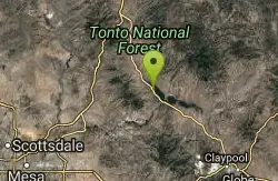
Three Bar Route
Tonto Basin, Arizona
42.9 miles SThe Three Bar Wildlife Enclosure is a fenced wildlife study area operated by Arizona Game and Fish. The proximity of two recreation sites provides ample parking should you want to cool...
Mountain Bike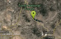
Vineyard Trail #131
Tonto Basin, Arizona
44.7 miles STrail passes through a variety of Lower Sonoran Desert vegetation plant communities. Spectacular views of Roosevelt Lake, Apache Lake, Roosevelt Dam and Four Peaks. Historic Camp...
Mountain Bike
Cathedral Rock Trail
Sedona, Arizona
48.7 miles NWStart off on the Bell Rock trail, go about 1.25 to 1.5 miles untill you locate the tunnel under Hwy 179 ( kinda hard to find without a map ). Go through the tunnel to start this fast...
Mountain Bike
Slim Shady
Sedona, Arizona
48.9 miles NWMeasuring 2.4 miles one-way, the Slim Shady trail forms the backbone of the Yavapai Point trail system and connects to Made in the Shade, Hiline, and more.
Mountain Bike
Bell Rock Area Trails
Sedona, Arizona
49.0 miles NWThe Bell Rock Area Trails is a trail system that extends from south of Courthouse Butte all the way up to the Little Horse Trail on the eastern side of Hwy 179. While this trail system...
Mountain Bike
Bell Rock Trailway
Sedona, Arizona
49.0 miles NWThis 3.5 mile trail is smooth & wide and built for multiple user groups, its very popular with hikers and dog walkers. The main reason for posting it here is that it acts like a...
Mountain Bike
Made In The Shade
Sedona, Arizona
49.0 miles NWThis is a singletrack connector that joins the Templeton Trail with the Village of Oak Creek. It is great either way but probably more fun from north to south. It has moderate climbs,...
Mountain Bike


