


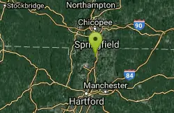
Map of 5 Hiking Trails near Westfield, Massachusetts
first prev 1 next lastShowing Hiking Trails within 50 miles Distance miles of Westfield, MA 01085, USA City, Zip, or Address
Windsor Locks Canal Trail
Suffield, Connecticut
12.1 miles SEThe 4.5 mile Windsor Locks State Park Canal Trail follows the historic towpath of this 170 plus year old historic waterway. The canal’s many vantage points offer the trail user scenic vistas...
Hike, Mountain Bike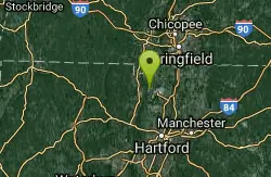
Metacomet Trail
East Granby, Connecticut
12.3 miles SThe Metacomet Trail is a 62.7-mile Blue-Blazed hiking trail that traverses the Metacomet Ridge of central Connecticut and is a part of the newly designated 'New England National Scenic...
Hike, Mountain Bike

Mohawk Mountain State Park
Cornwall, Connecticut
35.0 miles SWmostly logging roads, can be ridden rigid. Climb to the top of mohawk mountain and back down. Lots more to be explored, this is a good 15 miles and 1.5 hours of riding.1) at the dead end first road...
Cross-country Ski, Hike, Mountain Bike
Kent Falls State Park
Kent, Connecticut
42.0 miles SWPer the CT Dept of Energy and Environmental Protection: When the parking lot has reached capacity, the park is closed. It will reopen when the lot has 10 available spaces. Please note that there is...
Hike
Steep Rock
Washington, Connecticut
48.0 miles SWFrom Judd's Bridge, follow the road towards Washington and Steep Rock, go straight on the road that is perpendicular to the bridge. Follow it up into a curve and on the left there is a house with...
Hike, Mountain Bike


