Map of 7 Hiking Trails near Tillamook, Oregon
first prev 1 next lastShowing Hiking Trails within 50 miles Distance miles of Tillamook, OR 97141, USA City, Zip, or Address

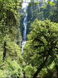
Munson Creek Falls
Tillamook, Oregon
7.1 miles SEThis park is home to several famous attractions along the Oregon Coast, including the tallest waterfall in the Coastal Range as well as several historic Western Red Cedar and Sitka Spruce. There...
Hike
Cape Lookout Trailhead
Cloverdale, Oregon
10.2 miles SWCape Lookout State Park has multiple hiking trails. This trail is among one of the more popular ones because it leads you to the steep cliffs which provide gorgeous views of the ocean and adjacent...
Hike
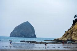
Cape Kiwanda
Pacific City, Oregon
17.6 miles SCape Kiwanda is a state natural area in Pacific City, Oregon. This is a fantastic place to spend an entire afternoon! You will see magnificent views of the basalt monolith officially called,...
Hike
Niagara Falls
Beaver, Oregon
19.8 miles SENot to be mistaken with the famous waterfall in Canada, this waterfall is rarely visited but very beautiful! Two waterfalls tumble down trying to out do the other, and it makes for a wonderous...
Hike
Oswald West State Park
Arch Cape, Oregon
22.3 miles NThis 2,484-acre state park is located just two hours west of Portland and provides numerous hiking and surfing opportunities. It's also home to one of the better beaches along the Oregon Coast...
Hike, Swim
Drift Creek Falls
Otis, Oregon
36.0 miles SHike this unique trail where you have the opportunity to walk on a 240-foot long cable suspension bridge! From the bridge, you will be able to see marvelous views of Drift Creek Falls below you!...
Hike
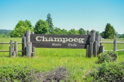
Champoeg State Park
Saint Paul, Oregon
48.5 miles EChampoeg State Park (commonly pronounced SHAM-poo-EE) is a historic pioneer site as well as a beautiful outdoor recreational area. The Native Americans originally pronounced it CHAM-po-EGG, but it...
Camp, Disc Golf, Hike, Mountain Bike


