


41 Hiking Trails near Lakeshore, California
first prev 1 2 3 next lastShowing Hiking Trails within 50 miles Distance miles of Lakeshore, CA 93634, USA City, Zip, or Address
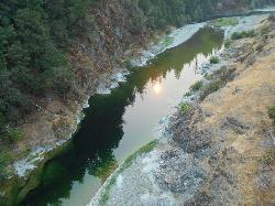
Standish Hickey Area
Lakeshore, California
10.0 miles NEStandish-Hickey is an inland river canyon that runs along Highway 101 just 180 miles from San Fransisco. It's home to a two-mile stretch of the south fork on Eel River, where many...
Backpack, Camp, Hike, Kayak, Swim

Crystal Lake
Mammoth Lakes, California
25.8 miles NUnlike many hikes in the Sierra's, Crystal lake can be done as a day hike and as the perfect way to get away for a bit. As hikers make their way to the lake, they will see the monolith Crystal...
Camp, Hike 2.5 mi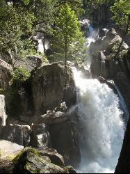
Chilnualna Falls
Wowana, Yosemite National Park
32.8 miles NWLocated near the southern entrance of the valley, Chilnualna Falls is one of the lesser known waterfalls in Yosemite. The hike is about 8 miles round trip and takes you to the upper part of the...
Hike 5.5 mi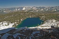
Ostrander Lake
Wawona, California
32.9 miles NWOstrander Lake is a long, 11.4 mile hike just behind Sentinel Dome. Unlike most of Yosemite's summer hikes, the trail to Ostrander Lake is open during the winter for people to ski through....
Hike, Swim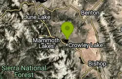
Crowley Lake
Mammoth Lakes, California
34.7 miles NENestled in the picturesque landscape near Benton, California, Crowley Lake stands as a hidden gem, known not only for its breathtaking natural beauty but also for the intriguing geological formations...
Hike, Swim 0.4 mi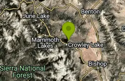
Crowley Lake Stone Columns
Mammoth Lakes, California
35.0 miles NENestled in the picturesque landscape of California's Eastern Sierra region lies Crowley Lake, a reservoir with a captivating secret beneath its surface – the Crowley Lake Stone Columns....
Hike 1.7 mi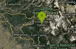
Mono Meadow
Yosemite West, Yosemite National Park
36.6 miles NWThe hike through Mono Meadow is the best way to get a view of Mt. Starr King, Clarke Range, and Half Dome all at once. It's about a three mile round trip hike towards Yosemite backcountry. It...
Hike 0.5 mi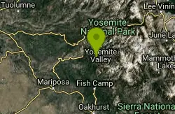
McGurk Meadow
Yosemite National Park
38.0 miles NWMcGurk Meadow is a short, 0.8 mile hike through one of Yosemite's wildflower meadows. The trail is fairly flat, about 100 feet of elevation gain, and it doesn't require too much effort,...
Hike 0.4-2.1 mi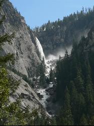
Illilouette Falls
Yosemite West, Yosemite National Park
38.2 miles NWIllilouette Falls Trail is a 4 mile hike down to Illilouette Creek, where there is a footbridge, a great view of Illilouette Falls, and several benches for onlookers to stop, rest, and...
Hike 1.9 mi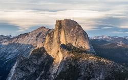
Half Dome
Yosemite Valley, Yosemite National Park
38.7 miles NWHalf Dome is the most popular and difficult hike in Yosemite Valley. The trail is about 14 miles long with an elevation gain of 4800 feet. There are cables to help you scale up to the summit once you...
Hike 1.9-2.9 mi
Mist Trail
Yosemite National Park
39.2 miles NWThe mist trail is a small breakoff from the John Muir Trail through Yosemite National Park. It's called the mist trail because of the heavy amount of mist that hikers walk through as Vernal and...
Backpack, Hike 0.3 mi
Glacier Point
Yosemite National Park
39.4 miles NWLocated in Yosemite National Park, Glacier Point gives a birds-eye-view of the park you can't find anywhere else. It can be accessed by both hiking and driving through the park, though the roads...
Hike 1.2 mi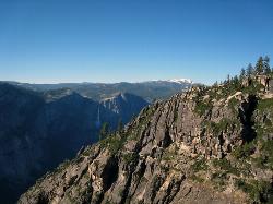
Taft Point
Yosemite Valley, Yosemite National Park
39.5 miles NWThe hike to Taft Point is often paired with the hike to Sentinel Dome. There is a 5 mile loop that connects the two and offers breathtaking views of the valley along the south rim. The trailhead...
Hike
Mirror Lake
Yosemite Valley, Yosemite National Park
39.8 miles NWMirror Lake is a seasonal lake situated in a secluded corner of the beautiful Yosemite Valley. The lake sits at the base of Half Dome and allows a different perspective of the famous monolith....
Backpack, Hike, Swim 4.6 mi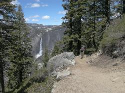
Four Mile Trail
Yosemite National Park
40.1 miles NWFour Mile Trail is a moderate hike that offers the best views of some of Yosemite's most famous landmarks, including Yosemite Falls, Half Dome, Clouds Rest, North Dome, El Capitan, and the Royal...
Hike 2.1 mi
Snow Creek Falls
Yosemite Valley, Yosemite National Park
40.5 miles NWSnow Creek is one of the more difficult waterfalls to find in the valley, but in the spring and summer months, the elusive waterfall can be seen from the Mirror Lake Trail, a 5 mile loop around...
Backpack, Hike 4.0 mi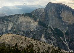
North Dome
Yosemite Valley, Yosemite National Park
40.7 miles NWNorth Dome is a strenuous 10.4 mile hike that gives visitors a close up view straight at Half Dome from across the valley. It also has a unique view of Clouds Rest peak. Because the hike...
Backpack, Hike 15.9 mi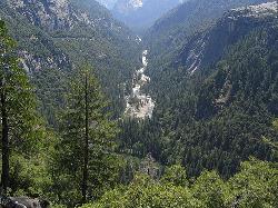
Valley Loop Trail
Yosemite Valley, Yosemite National Park
41.0 miles NWThe Valley Loop trail at the heart of Yosemite is one of the best ways to discover the park. The entire loop is 11.5 miles long, and there are several places to enter and exit the trail...
Hike 0.7 mi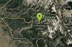
Cook's Meadow Loop
Yosemite Valley, Yosemite National Park
41.0 miles NWCook's Meadow Loop is a shorter, smaller hike inside Sentinel Meadow. Cook's Meadow Loop is just under a mile and takes about 45 minutes to complete, depending on how long you stop at each...
Hike 0.2 mi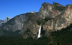
Bridalveil Falls
Yosemite Valley, Yosemite National Park
41.1 miles NWKnown for being the focal point for one of Ansel Adams' most famous photographs, Bridalveil Falls is one of the first waterfalls you see as you enter Yosemite. The path to get there...
Hike


