


8 Hiking Trails near Dayton, Nevada
Showing Hiking Trails within 50 miles Distance miles of Dayton, NV, USA City, Zip, or Address
Skunk Harbor
Carson City, Nevada
19.6 miles WThis hike starts from the 28 freeway and follows a forest service road. There are a couple of points where you can get some nice views from the trail. There are some mountain biking trails that can...
Hike
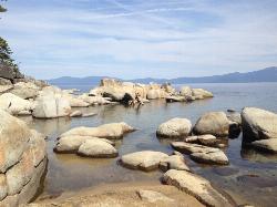
Zephyr Cove Park
Glenbrook, Nevada
24.5 miles SWZephyr Cove Park is located 4.6 miles off highway 50 in Nevada. This park is a great place to have your summer activities; it includes Picnic tables for groups and couples, Barbecue...
Camp, Canoe, Disc Golf, Hike, Horseback, Kayak, Swim 4.1 mi
Shirley Lake Canyon Trail
Olympic Valley, California
34.8 miles WShirley Lake is a pretty and pure lake located in Squaw Valley. The Shirley Lake Canyon Trail goes up into the rugged and lovely Sierra Mountains. You begin the trail in Squaw Valley Village and...
Hike, Swim
Shirley Canyon
Olympic Valley, California
35.3 miles WHike near Olympic Valley, California
Hike 0.4 mi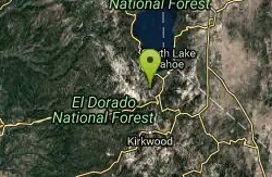
Glen Alpine Falls
South Lake Tahoe, California
35.7 miles SWAs you drive up to the falls, take a look around. The views are spectacular. The drive can feel long, but the waterfall is peaceful and worth the drive. This waterfall is considered one of the...
Hike
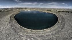
Soda Lake Area
Fallon, Nevada
42.6 miles NEGeneral description: A large lake in a volcano outside the town of Fallon. Soda Lake consists of a large body of water in a relatively young volcano, fed by numerous hot springs. Although no bathing...
Hike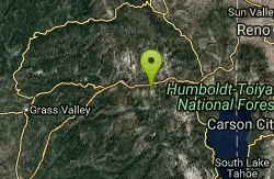
Heath Falls Overlook Trail
Truckee, California
45.3 miles WHike and Swim near Truckee, California
Hike, Swim
Palisades Creek Trail
Truckee, California
45.3 miles WThe Palisades Creek Trail is a difficult hike that can be done in a day, but is better enjoyed as an overnight trip. This trail has showcases some beautiful waterfalls along the way as well as...
Hike, Swim


