


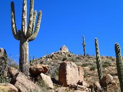
113 Hiking Trails near Park Trail #66
first prev 1 2 3 4 5 6 next lastShowing Hiking Trails within 50 miles Distance miles of Nf-409, Tonto Basin, AZ 85553, USA City, Zip, or Address

Denton Trail #69
Tonto Basin, Arizona
5.2 miles SFrom FR 421, the trail climbs steadily up the east face of the mountain. Some sections are quite steep. The trail eventually tops out at 5,760 feet elevation and then descends to Big Pine Flat for...
Hike, Mountain Bike 1.4 mi
Ballantine Trail
Rio Verde, Arizona
11.3 miles SWthis trail looks a lot better once it moves away from the highway. A somewhat strenuous climb reveals a landscape of knuckle-and-joint, mica-imbedded boulders, deep gorges and a battalion of regal...
Hike 0.8-2.2 mi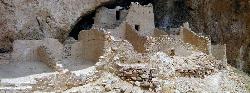
Tonto National Monument
Roosevelt, Arizona
20.3 miles SEHike near Roosevelt, Arizona
Hike
Tortoise and Hilltop Trails
Fort McDowell, Arizona
25.3 miles SWBe on the lookout for wildlife like jackrabbits and lizards on the initial stretch of trail (Tortoise Trail) and for mountain bikers as this trail joins the Pemberton Trail for a bit as...
Hike
Wagner Trail
Scottsdale, Arizona
25.4 miles SWWagner Trail is a 2.2 mile, beginner to intermediate loop trail located in the McDowell Sonoran Preserve. The trail is well-marked and easy to follow; this wide, but rugged...
Hike, Horseback, Mountain Bike
Wagner-Granite-Bluff Trails
Scottsdale, Arizona
25.4 miles SWHike and Mountain Bike near Scottsdale, Arizona
Hike, Mountain Bike
Fountain Hills Park
Fountain Hills, Arizona
28.0 miles SWFountain Park is a 1.3 mile loop trail located near Phoenix, Arizona ( in Fountain Hills) and is good for all skill levels. The trail is primarily used for hiking and is accessible...
Hike
Hell's Gate
Payson, Arizona
28.0 miles NEThis Wilderness was established in 1984, and contains approximately 37,440 rough acres with a major canyon and perennial stream extending its entire length. Deep pools of water may be separated by...
Backpack, Camp, Hike, Swim
Fountain Park Trail
Fountain Hills, Arizona
28.0 miles SWFountain views, Four Peaks view, desert vegetation, close to coffee! The trail is well groomed and well marked. It parallels some house as you begin to go up the first hill. About 15...
Hike, Mountain Bike 2.1 mi
Lower Salt River Nature Trail
Fort McDowell, Arizona
28.9 miles SWThe Lower Salt River Nature Trail is a scenic walk to take at the Tonto National Forest. This trail provides stunning views as you walk alongside the Salt River. This rustic trail is older and less...
Camp, Hike 2.2 mi
Marcus Landslide Trail
Scottsdale, Arizona
29.0 miles SWThe Marcus Landslide Trail is named after ASU professor Melvin Marcus, a renouned geographer, after the discovery and recognition of the interesting geographical area in 2002. More than 500,000...
Hike, Horseback, Mountain Bike, Rock Climb
Tom's Thumb Trail
Scottsdale, Arizona
29.0 miles SWTom's Thumb Trail is a popular trail on the McDowell Sonoran Preserve due to its unique thumb-like granite rock formation. This is a 4.7 out-and-back, intermediate trail because of its 1,200...
Hike, Mountain Bike, Rock Climb
Tom's Thumb, Feldspar, and Marcus Landslide Loop
Scottsdale, Arizona
29.0 miles SWHike near Scottsdale, Arizona
Hike
Dixie Mine
Fountain Hills, Arizona
29.3 miles SWMcDowell Mountain Regional Park 16300 McDowell Mountain Park Dr. MMRP Arizona 85255 Ph: 480-471-0173 Fax: 602-372-8507 [email protected] Mailing...
Hike
Thompsons Peak
Fountain Hills, Arizona
29.3 miles SWHike near Fountain Hills, Arizona
Hike
Sonoran Trail Fountain Hills
Fountain Hills, Arizona
29.4 miles SWHike near Fountain Hills, Arizona
Hike
Siphon Draw Trailhead to Flatiron
Apache Junction, Arizona
29.4 miles SThe Siphon Draw Trail up to Flatiron is a beautiful trail within the Lost Dutchman State Park. It is a 5.5 mile, there and back trail near Apache Junction, Arizona. It is a more advanced hike with...
Hike
Brown Ranch Trail to Cone Mountain Trail
Scottsdale, Arizona
29.7 miles WHike near Scottsdale, Arizona
Hike
Jane Rau Brown's Canyon Trail
Scottsdale, Arizona
29.7 miles WThe Jane Rau Brown Canyon Trail was named after Jane Rau Brown, one of the pioneers of the McDowell Sonoran Conservancy, for her determination and passion in preserving the desert and the park....
Hike, Horseback, Mountain Bike
Pima and Dynamite Trail
Scottsdale, Arizona
29.7 miles WPima and Dynamite is an area with a network of trails for hiking, but more popularly for mountain biking, in North Scottsdale, Arizona. The area feautures a variety of trails for...
Hike, Mountain Bike


