


3 Hiking Trails near Northampton State Hospital
first prev 1 next lastShowing Hiking Trails within 50 miles Distance miles of 53-171 Burts Pit Rd, Northampton, MA 01060, USA City, Zip, or Address
Add Location
Windsor Locks Canal Trail
Suffield, Connecticut
22.7 miles SThe 4.5 mile Windsor Locks State Park Canal Trail follows the historic towpath of this 170 plus year old historic waterway. The canal’s many vantage points offer the trail user scenic vistas...
Hike, Mountain Bike
Metacomet Trail
East Granby, Connecticut
25.6 miles SThe Metacomet Trail is a 62.7-mile Blue-Blazed hiking trail that traverses the Metacomet Ridge of central Connecticut and is a part of the newly designated 'New England National Scenic...
Hike, Mountain Bike
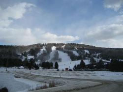
Mohawk Mountain State Park
Cornwall, Connecticut
47.1 miles SWmostly logging roads, can be ridden rigid. Climb to the top of mohawk mountain and back down. Lots more to be explored, this is a good 15 miles and 1.5 hours of riding.1) at the dead end first road...
Cross-country Ski, Hike, Mountain Bike


