


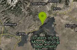
13 Hiking Trails near Imperial Gulch Trail
first prev 1 next lastShowing Hiking Trails within 50 miles Distance miles of Greenhorn Gulch, Hailey, ID 83333, USA City, Zip, or Address
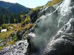
Skillern Hot Springs
Fairfield, Idaho
20.3 miles WSkillern hot spring is located in Fairfield, Idaho. It is a stunning six mile hike. The trail to Skillern hot spring follows the beautiful Big Smoky Creek, which gives life to the forest. Big Smoky...
Camp, Hike, Hot Springs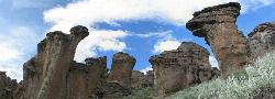
Little City of Rocks
Gooding, Idaho
35.5 miles SNot to be confused with the City of Rocks National Reserve, Little City of Rocks is located near Gooding, Idaho. There are two portions to the area, the Little City of Rocks and the Gooding City...
Camp, Hike
North Crater Flow
Arco, Idaho
44.0 miles EHike near Arco, Idaho
Hike 1.8 mi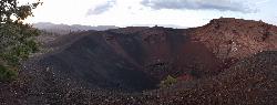
North Crater Trail
Visitors Center, Craters of the Moon National Monument
44.3 miles EThis one-way trail is especially interesting for its variety. The trail traverses North Crater and drops into the crater mouth, the vent for the North Crater flow. Notice that the northwest flank of...
Hike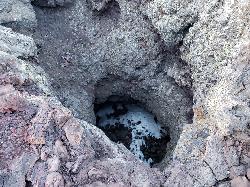
Snow Cone
Visitors Center, Craters of the Moon National Monument
44.3 miles EHike near Visitors Center, Craters of the Moon National Monument
Hike 0.1 mi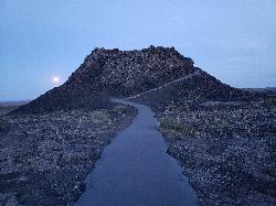
Spatter Cones
Visitors Center, Craters of the Moon National Monument
44.3 miles EThese miniature volcanoes formed when blobs of molten lava were lobbed into the air during the last gasp of an eruption sequence that ended about 2,100 years ago. Craters of the Moon is well known...
Hike 0.4 mi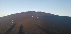
Inferno Cone
Visitors Center, Craters of the Moon National Monument
44.6 miles ECinder cones form when gas-rich volcanic froth erupts high into the air and then piles into a mound. Climb Inferno Cone, if you wish, but don't be disappointed if you are unable to locate the...
Hike 1.9 mi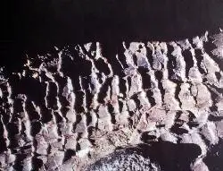
Tree Molds Trail
Visitors Center, Craters of the Moon National Monument
45.0 miles EWhen molten lava advanced through this area it flowed through a grove of living trees. As the trees burned, moisture was released as steam, cooling the hot lava just enough to leave an impression of...
Hike 1.7 mi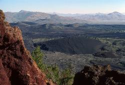
Broken Top Loop Trail
Visitors Center, Craters of the Moon National Monument
45.0 miles EThe Broken Top Loop Trail provides an opportunity to hike over, under and around the youngest volcano on the Snake River Plain. The event that created this cinder cone and associated lava flows...
Cave, Hike 8.8 mi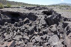
Wilderness Trail
Visitors Center, Craters of the Moon National Monument
45.0 miles EYou will have a sense of solitude as you travel into the Craters of the Moon Wilderness. Begin the trail on the sidewalk that parallels the roadway and turn right to follow the direct route across a...
Cave, Hike 0.5 mi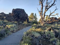
Devil's Orchard Trail
Visitors Center, Craters of the Moon National Monument
45.1 miles EThis paved trail explores an area of cinder beds scattered with pieces of the North Crater wall. Exhibits along the trail challenge you to consider the difficulties of protecting this fragile...
Hike 1.0-1.3 mi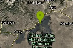
Caves Trail
Visitors Center, Craters of the Moon National Monument
45.4 miles ECave and Hike near Visitors Center, Craters of the Moon National Monument
Cave, Hike 7.9 mi
Borah Peak
Mackay, Idaho
47.1 miles NEThis is the highest peak in all of Idaho, standing 12,662 ft along the Lost River Range. There are several routes that can be taken in order to reach the summit with different levels of difficulty...
Hike


