


137 Hiking Trails near Desert West Skateboard Plaza
first prev 1 2 3 4 5 6 7 next lastShowing Hiking Trails within 50 miles Distance miles of 6602 W Encanto Blvd, Phoenix, AZ 85035, USA City, Zip, or Address
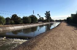
Grand Canal Trail
Phoenix, Arizona
5.2 miles EThe Grand Canal Trail is a 23-mile long system of paved and unpaved trails located in Glendale, Phoenix and Tempe that travels through...
Hike
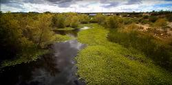
Rio Salado Habitat Restoration Area
Phoenix, Arizona
8.2 miles SEHike near Phoenix, Arizona
Hike 8.3 mi
Estrella Mountains Competitive Track
Tolleson, Arizona
9.9 miles SWThe third competitive track in the Maricopa County Regional Park system, located in Estrella Mountain Regional Park, was completed in February 2000. The track consists of two loops totaling 13 miles....
Hike, Horseback, Mountain Bike
Glendale Canal
Glendale, Arizona
9.9 miles NHike, Horseback, and Mountain Bike near Glendale, Arizona
Hike, Horseback, Mountain Bike
Maxine Lakin Nature Trail
Phoenix, Arizona
10.0 miles NEHike near Phoenix, Arizona
Hike 1.2 mi
Ma-Ha-Tauk Trail
Phoenix, Arizona
10.3 miles SEMa-Ha-Tauk Trail can be found in South Mountain Park in Phoenix. This is a 2.5 mile, out-and-back trail. Aside from a short section of steeper incline in the first part of the hike, this is an...
Hike, Horseback 4.6 mi
Perl Charles Memorial Trail (#1A)
Phoenix, Arizona
10.3 miles NEThis is a technical singletrack loop with some very steep up and down sections located in the Phoenix Mountain Preserves. This trail is for advanced riders who like to bleed and leave their skin on...
Hike, Horseback, Mountain Bike 12.6 mi
National Trail
Phoenix, Arizona
10.5 miles SNational Trail is the gem of South Mountain and home to the infamous Waterfall. It’s a local favorite as well as a destination trail for MTB snowbirds. Like most trails in the Sonoran...
Hike, Mountain Bike
Alta Trail And Bajada Trail
Phoenix, Arizona
10.5 miles SHike near Phoenix, Arizona
Hike
Arizona Canal Trail
Phoenix, Arizona
10.7 miles EMulti-purpose canal trails set apart from normal city traffic and noise. The Arizona Canal is one of the many canals used to supply the valley with its water needs (irrigation). These canals were...
Hike, Horseback
Max Delta
Phoenix, Arizona
11.0 miles SEThis trails follows close to San Juan Rd. Part of the trail is rocky while other parts are well just dirt. Max Delta Trail is a 2.7 mile trail within Phoenix, Arizona on the South Mountain...
Hike
North Mountain National Trail
Phoenix, Arizona
11.1 miles NENorth Mountain National Trail is a 2.3 mile moderate, loop trail near Phoenix. It's easy to travel on if you go up the paved sections. The inclines are steep in parts, making it a real...
Hike 3.8 mi
Freedom Loop Trail (#302)
Phoenix, Arizona
11.2 miles NEFreedom Trail (#302), also known as Piestewa Circumference, is a 3.8 mile, moderate loop trail. You can access this trail from all the inner trailheads. The easiest and least...
Hike 2.2 mi
Piestewa Peak Summit Trail #300
Phoenix, Arizona
11.2 miles NESome people still refer to the Peak by its original name of "Squaw Peak" before its name changed to "Piestewa Peak" in honor of Lori Piestewa who died serving her country in the...
Hike 0.2-5.0 mi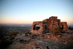
Holbert Trail to Dobbins Lookout
Phoenix, Arizona
11.3 miles SEStart out at the main entrance to South Mountain and make a left past the vistor's center. Go to the end of the road to the beginning of Holbert Trail. Get to the top and make a right to Dobbins...
Hike
Holbert-Hidden Valley-Mormon Trail Shuttle
Phoenix, Arizona
11.3 miles SEHolbert- Hidden Valley- Mormon Trail is a combination trail hike on the north side of South Mountain near Phoenix, Arizona. This trail is approximately 6.5 miles long, and is suitable for...
Hike, Mountain Bike 1.4 mi
Mohave Trail (#200)
Phoenix, Arizona
11.5 miles NEAn invigorating swift hike is what Mohave Trail 200 provides for anyone looking for a free and quick escape. Though the main attraction of the Phoenix Mountain’s Preserve is the larger Piestewa...
Hike, Horseback
Shaw Butte and Charles M Christiansen Loop Trail
Phoenix, Arizona
11.5 miles NEWhen you say "North Mountain," I think most Arizonans know where it is or can find it. When you say "Shaw Butte," it seems like you get a lot more questioning glances and "huh?". Shaw...
Hike, Mountain Bike 1.7 mi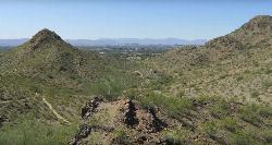
Quartz Ridge Trail
Phoenix, Arizona
11.6 miles EThis is a very popular trail on weekend mornings. Casual hikers can get great views of Phoenix with moderate effort. Good place to bring out of town visitors The Quartz Ridge Trail is a short,...
Hike, Mountain Bike
Baseline Trail
Goodyear, Arizona
11.6 miles SWThe Baseline trail is a 2.6 mile loop at Estrella Mountain Regional Park. This listing is based on access from a spur trail (33.378981, -112.371072) off of the Gila trail. Access is...
Hike


