


137 Hiking Trails near Chandler Skatepark
first prev 1 2 3 4 5 6 7 next lastShowing Hiking Trails within 50 miles Distance miles of 4519 S Basha Rd, Chandler, AZ 85248, USA City, Zip, or Address
Corona de Loma Trail
Phoenix, Arizona
10.7 miles NWquick climb to the top of Buena Vista lookout. Great view of the east vally
Hike
Corona Loop
Phoenix, Arizona
10.7 miles NWThis is a good hike, take plenty of water and a map or gps would be a very good ideal. I went up the day after we got over a inch of rain so lot of places were washed out. i looked like...
Hike
Riparian Preserve at Water Ranch Trail
Gilbert, Arizona
11.1 miles NEThe Riparian Preserve is an urban park with a series of loop trails surrounding seven ponds stocked with fish and birds. It is located at 2757 E. Guadalupe Road, Gilbert AZ. Several...
Canoe, Hike
South Mountain National Trail
Phoenix, Arizona
11.2 miles NWThe National Trail crosses South Mountain Park from the east to the west ends and intersects with most of the other trails in the park. A very scenic hike with moderate ups and downs...
Hike, Mountain Bike
Desert Classic - Goat Trail
Phoenix, Arizona
11.2 miles NWHike and Mountain Bike near Phoenix, Arizona
Hike, Mountain Bike
Old Man Trail
Phoenix, Arizona
11.2 miles NWRanger Office Phone: (602) 262-7393 Hours for all trailhead areas and entrances: 5 a.m. to 7 p.m. (entrance gates close). Trails remain open until 11 p.m.
Hike
National to Hidden Valley to Mormon Loop
Phoenix, Arizona
11.2 miles NWHike near Phoenix, Arizona
Hike 1.5 mi
Desert Classic
Phoenix, Arizona
11.2 miles NWThe Desert Classic trail is just that, a classic at the South Mountain Park area. Because it is such a classic, the trail is well marked and well worn by high traffic flow of riders and hikers....
Hike, Mountain Bike
Pima Wash Trail to West Loop
Phoenix, Arizona
11.2 miles NWHike near Phoenix, Arizona
Hike 2.1 mi
Marcos de Niza & Pima
Phoenix, Arizona
11.2 miles NWIf you're looking to: get off the tourist highway trail, enjoy killer South Mountain views, take a rollercoaster for a hike with an easy stroll or jog back to the start - this is a loop you...
Hike
South Mountain Trails (Desert Classic Trail)
Phoenix, Arizona
11.2 miles NWHike and Mountain Bike near Phoenix, Arizona
Hike, Mountain Bike 1.8 mi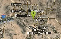
Javelina-Beverly Canyon Loop Trail
Phoenix, Arizona
11.8 miles NWJavelina Canyon Trail does have some beautiful hills and valleys to wander through and it feels down right remote at times. I’ve found Javelina to have less traffic that Beverly as...
Hike, Horseback, Mountain Bike 1.9 mi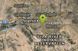
Javelina Trail
Phoenix, Arizona
11.8 miles NWComing down Javelina is fast and fun no doubt. It sure beats the crowded Pima Canyon trail back to the Pima lot if you parked there. Javelina is just one more sweet trail on South Mountain. Not a...
Hike, Horseback, Mountain Bike 2.5 mi
Hidden Valley from Buena Vista Trail
Phoenix, Arizona
12.8 miles NWFor an easily accessible trail, butting right up against Phoenix’s southern border, it is truly surprising how special, quiet and natural the hike through Hidden Valley is! The path...
Hike, Mountain Bike 6.1 mi
Goat Hill via Telegraph Pass Trail
Phoenix, Arizona
13.1 miles NWThe views from the top of Goat Hill are awesome on a clear day as you can enjoy a 360 view. Telegraph Trail is kind of a sidewalk part of the after that a little bit rocky until you reach the summit...
Hike
Telegraph Pass Trail
Phoenix, Arizona
13.1 miles NWTelegraph Pass Trail is a 2.3 mile beginner friendly, out-and-back trail in South Mountain Park in Phoenix. The first third or so of Telegraph Trail is paved, making it wheelchair...
Hike 2.3 mi
Hidden Valley Trail Via Mormon Trail
Phoenix, Arizona
13.2 miles NWHidden Valley Trail via Mormon Trail is a 2-4 mile hike, depending on the route you choose to take and how much additional exploring you do. This hike offers a natural rock tunnel, petroglyphs,...
Hike, Mountain Bike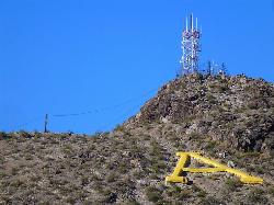
'A' Mountain at Hayden Butte
Tempe, Arizona
13.5 miles N'A' Mountain aka Hayden Butte, is a popular hike in downtown in Tempe, Arizona. This hike located partially on Arizona State University's campus, is a short, easy walk, though it's...
Hike
Hayden Butte And Tempe Town Lake Trail
Tempe, Arizona
13.7 miles NHike near Tempe, Arizona
Hike 0.8-1.0 mi
Kiwanis Trail to Telegraph Pass Lookout
Phoenix, Arizona
14.3 miles NWAn ideal hike to take children on as the distance is short and the elevation gain is not extreme. Avid hikers have opportunities to embark on longer hikes into South Mountain. ... This short hike is...
Hike, Mountain Bike


