


Map of 6 Backpacking Trails near Saratoga Springs, Utah
first prev 1 next lastShowing Backpacking Trails within 50 miles Distance miles of Saratoga Springs, UT, USA City, Zip, or Address
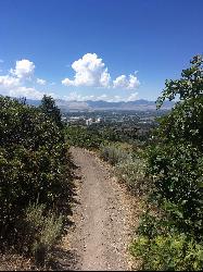
Corner Canyon Trail
Draper, Utah
12.5 miles NCorner Canyon is the "Go To" riding area in South Salt Lake and for many riders it is worth the drive (or ride) from Utah County. It is a good mix of everything from beginner training...
Backpack, Hike, Mountain Bike 1.5 mi
Timpanogas Cave
Provo, Utah
13.0 miles NEKnown for it's colorful cave decorations, the Timpanogas cave attracts numerous visitors per year, is steep but it's paved so that visitors can access the cave. To access the cave, visitors...
Backpack, Cave, Hike 1.1-4.7 mi
Bells Canyon
Sandy, Utah
17.1 miles NBells Canyon is a moderate, 4.5 mile hike that begins in a residential area and ends at a waterfall in the enter of the canyon's forest. The first 1/2 mile of the hike is relatively...
Backpack, Hike, Mountain Bike, Snowshoe
Pfeiferhorn Peak
Provo, Utah
20.6 miles NEThe Pfeifferhorn is a majestic peak, which is located east of Salt Lake City, Utah in the Wasatch mountain range. It's easy access, proximity to alpine lakes and short trail make it a popular...
Backpack, Hike 4.7 mi

Fifth Water Hot Springs
Provo, Utah
33.6 miles SEAKA Diamond Fork Hot Springs A beautiful drive and a 2.5 mile hike along the river will end you at an amazing set of hot springs that's well worth the trip. There's a variety of...
Backpack, Camp, Hike, Hot Springs, Mountain Bike, Swim
Holbrook Trailhead
Bountiful, Utah
38.2 miles Nairsoft feaild woth bunkers
Airsoft, Backpack, Camp, Paintball, Snowshoe


