


White Tanks Competitive Track
Waddell, Arizona
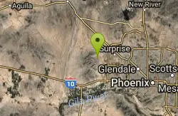
| Address: | ~Sonoran Loop, Waddell, AZ 85355, USA |
| GPS: |
33°36'30.8"N 112°30'3.1"W Maps | Directions |
| State: | Arizona |
| Trail Length: | 10.00 miles |
| MTB Difficulty: | Intermediate |
| Trail Type: | Loop |
| MTB Trail Type: | Singletrack |
Mountain Bike
Nice climbs and nice technical downhills. Courtesy of Singletracks.com
More Information
Never modify trail features. Ride trails when they're dry enough that you won't leave ruts. Speak up when you see others on the trail and always yield to hikers, horses, and others coming uphill. Always ride on the established trail.
Read More- Plan Ahead and Prepare
- Travel & camp on durable surfaces
- Dispose of waste properly
- Leave what you find
- Minimize campfire impacts
- Respect wildlife
- Be considerate of other visitors
Directions
From Waddell, Arizona
- Head southeast on W Burton Ave toward N Cortessa Pkwy (26 ft)
- Turn right onto N Cortessa Pkwy (0.7 mi)
- Turn right onto W Olive Ave (2.5 mi)
- Continue onto W White Tank Mountain Rd (3.5 mi)
- W White Tank Mountain Rd turns slightly right and becomes White Tank Mtn Rd (0.1 mi)

Other Mountain Bike Trails Nearby

Mule Deer Trail (Maricopa Trail)
Waddell, Arizona
1.5 miles SMule Deer trail is a 3.5 mile out-and-back trail that it part of the Maricopa Trail within White Tank Mountain Regional Park. This is a beginner to moderate friendly trail for both hikers and...
Hike, Horseback, Mountain Bike
Goat Camp Trail
Buckeye, Arizona
2.8 miles SGoat Camp Trail is a well-liked mountain biking and hiking trail in White Tank Mountain Regional Park. This is a 16 mile out-and-back trail that is rated as advanced due to the length, as well as the...
Hike, Mountain Bike
South, Bajada, Mule Deer Loop Trail
Waddell, Arizona
3.0 miles SSouth - Bajada - Mule Deer Loop is a 4.1 mile loop trail located near Waddell, Arizona that offers the chance to see wildlife. The trail is rated as moderate and is accessible from...
Hike, Horseback, Mountain Bike
White Tanks Regional Park Trails
Waddell, Arizona
3.1 miles SI have not ridden these trails yet, but I was surprised that they were not listed yet on the ST's database. There are 28 miles of multi-use trails in the park, not including the park's...
Mountain Bike 4.8 mi
Lost Creek Petroglyph Trail
Buckeye, Arizona
8.1 miles SStarting at Verrado's trailhead, the trail heads a short ways to a petroglyph site. While a little rocky at times, the trail is easy. To deter vandals, a very necessary fence with barbed-wire has...
Hike, Mountain Bike
Verrado
Buckeye, Arizona
8.1 miles STechnical, good climbs, lots of open roads to add cardio loops as well.
Mountain Bike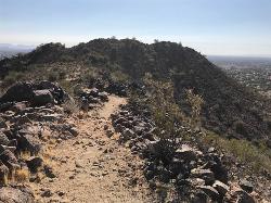
Sunrise Mountain Trail
Peoria, Arizona
16.7 miles NEThe Sunrise Mountain Trail can be found within the suburban area of Peoria, Arizona; it is made of up 3 sequential loops; each loop harder than the last. The trail is easy to find, as...
Hike, Mountain Bike 1.0 mi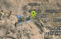
Quail Trail
Goodyear, Arizona
17.1 miles SEQuail Trail is the access trail from the Nature Center to the main trail system. It is a pretty steep climb, but smooth and steady. Quail Trail is a spur trail in the Estrella Mountain...
Hike, Horseback, Mountain Bike
Glendale Canal
Glendale, Arizona
17.9 miles EHike, Horseback, and Mountain Bike near Glendale, Arizona
Hike, Horseback, Mountain Bike
Rainbow Valley to Toothaker Loop Trail
Goodyear, Arizona
18.0 miles SEEstrella Mountain Regional Park has many trails within it, a great beginner to intermediate friendly trail is the Rainbow Valley to Toothaker Loop Trail. This 6.6 mile hike is mostly flat with a few...
Hike, Horseback, Mountain Bike
Dysart Trail
Goodyear, Arizona
18.0 miles SE$6 entry fee per car.
Hike, Horseback, Mountain Bike
Estrella Mountain Park
Goodyear, Arizona
18.1 miles SENice mix of singletrack and doubletrack. One way loops, long loop and tech loop. A few mild climbs and some mild rock gardens, just let it ride. There is a lot of loose rocks on the...
Mountain Bike 3.6 mi
Toothaker Trail
Goodyear, Arizona
18.1 miles SEToothaker is an easy roller coaster of a trail. It crosses numerous washes ranging from small to large and can be a tad loose and/or rocky in some sections. The end reward is a nice view of Rainbow...
Hike, Horseback, Mountain Bike
Dixie mountain
Glendale, Arizona
18.1 miles EGreat network of trails including some beginner to intermediate. Connect as many loops as you want to get the desired distance or connect to the north Sonoran preserve via connector...
Mountain Bike 13.8 mi
Butterfield to Gadsen Loop Trail
Goodyear, Arizona
18.1 miles SEAs with other trails in Estrella, the trail is wide and the surface tends to be rather benign, varying from mostly smooth, to occasionally strewn with small rocks, sandy in the washes. Butterfield...
Hike, Horseback, Mountain Bike 2.9 mi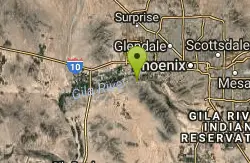
Coldwater Trail
Goodyear, Arizona
18.2 miles SEThe Cold Water Trail #27 is a seldom visited, remote backcountry destination along the backdrop of the rugged Verde Rim with healthy mixed vegetation and unique geology. The trail was originally used...
Hike, Horseback, Mountain Bike
Sonoran Preserve North
Phoenix, Arizona
18.7 miles NENice rolling single track with many steep sustained climbs and fun flawy downhills. No technical features but good fitness is needed. If you do all the climbs and loops can get in over...
Mountain Bike
Thunderbird Park
Phoenix, Arizona
18.7 miles NEThis trail is very rocky. Bring plenty of water because there is no shaded areas and it gets hot in Arizona. Overall a fun trail. I used a hard tail with a head shock but took it...
Mountain Bike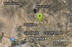
H-1 to H-4 Trails Loop
Glendale, Arizona
18.7 miles EThunderbird Park in Glendale, AZ consists of 5 H-Trails, named so because of the Hedgpeth Hills through which they wind. H-1: One-Way - 5.0 miles H-1a: Loop trail - 2.5 miles - 400...
Hike, Mountain Bike
Thunderbird H-1 H-2 H-3 Loop Trail
Glendale, Arizona
19.5 miles EHike and Mountain Bike near Glendale, Arizona
Hike, Mountain Bike


