Whipple Cave
Pioche, Nevada
| Address: | Pioche, NV 89043, USA |
| GPS: |
38°30'43.9"N 114°58'8.8"W Maps | Directions |
| State: | Nevada |
Trails Rocks Pet Friendly
Camp, Cave, and Hike
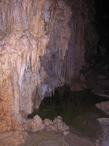
Whipple cave is located in the Egan mountains in Nevada. The mountains are limestone and over centuries, water has dissolved through long tube-like cave that's approx. 70 to 90 ft wide and 60 to 70 ft. high. Water has also continued to move through the mountain and seep into the cave, creating an array of unique and interesting cave formations such as stalagmites, stalactites, columns, flow stone, soda straws, cave bacon, popcorn, and various crystals. You will need a 165 ft rope and headlamps to rappel into the cave. There are some spots within the cave that climbers can squeeze through in order to get in certain place in the cave. You can camp on the outskirts of the cave at night time, it's free but it does get windy at sunset.
More Information
Be courteous, informed, and prepared. Read trailhead guidelines, stay on the trail, and don't feed the wildlife.
Read MoreDirections
From Pioche, Nevada
- Head north on NV-321 N toward Pioche St (2.3 mi)
- Continue straight onto US-93 (11.2 mi)
- Turn left toward Bristol Wells Rd (141 ft)
- Turn right onto Bristol Wells Rd (6.2 mi)
- Slight right toward Silver King Rd (253 ft)
- Continue onto Silver King Rd (1.5 mi)
- Slight left toward Sunnyside Rd (190 ft)
- Continue onto Sunnyside Rd (18.2 mi)
- Turn right onto NV-318 N (26.5 mi)
- Turn right (1.8 mi)
- Continue onto Shingle Pass Rd (0.4 mi)
- Continue straightDestination will be on the left(1.7 mi)
Driving here is a little weird. RoadTripRyan's description pretty confusing and GPS gets you near but doesn't tell you correctly which roads to take once leaving the free way.
Directions are as follows:
- Leave Highway 318 and turn East onto Shingle Pass Road. (38.520859, -115.024956)
- Pass several right turns and fences until the road curves right and take a sharp right (38.534723, -114.966196)
- The road will wind back and go along the culvert unit it turns left an become a straight line (38.526609, -114.981474)
- Take a left the the T-intersection and drive up towards Whipple Cave (38.516252, -114.976886)
- Park by the Whipple Cave interpretive signs or the 30m up the hill.
You need at least an standard SUV level clearance. The roads were rutted and had many hidden rocks.
From parking the car its a 50m walk down a clear trail to a cave with two openings separated by a rock bridge. Courtesy of http://ropewiki.com/


