1.1K Great Running Trails by nicole97
first prev 1 next last
Farmington Canyon
Farmington, Utah
0.9 miles N of Farmington, UtahFarmington Canyon is a gorgeous location to explore during all four seasons of the year, but the prime months for visiting are April through October. The dusty Skyline Drive long is along a gravel road and very bumpy to drive up. It is closed for cars during the winter months. The road connects Farmington to Bountiful thus providing access to Francis Peak, Bountiful Peak as well as the Smith Lakes.
The colors of the leaves within the canyon are incredibly vibrant throughout the year, especially in autumn. Farmington Canyon is a great place to take a bumpy yet beautiful car ride, to go camping, trail running or enjoy a scenic walk. The Farmington Creek Trail includes rocks to climb over as well as stream crossings and does not have much shade covering. Farmington Canyon provides an incredible view of Kaysville and the Great Salt Lake.
The Sunset campground, composed of 16 sites, is located on the Farmington side, 3.6 miles from the pavement is on the ridge of the canyon. Located further up the canyon is the Bountiful Peak campground which has 21 sites. Located at the bottom of the canyon is Farmington Pond which is another place to visit and includes picnic tables and a paved trail.

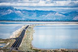
Antelope Island
Syracuse, Utah
9.3 miles W of Syracuse, UtahAntelope Island State Park, the largest island in the Great Salt Lake, is home to a roaming herd of 500 bison. Pronghorn and bighorn sheep also share the rangelands that overlook the desert lake. Opportunities to view wildlife are available on backcountry trails, which are open to horseback riding, mountain biking, hiking and cross-country skiing. Please keep in mind that pets on leash are allowed on the island except on the Frary Peak trail. A visitor center offers information on the island's unique biology, geology and history. Please be aware that, during the month of May and part of June (usually until the weather reaches 90 degrees), Antelope Island has biting gnats (or "no see'ums"). Wear a hat or light hoodie and protect your face and neck with bugspray. Insects on the causeway are midges that don't bite, and brine flies along the lake's edge are harmless. Courtesy of AllTrails.com
Antelope Island is located on the east side of Utah's Great Salt Lake. Trails include:
- Lakeside Trail
- White Rock Loop
- Split Rock Bay Loop
- Elephant Head
- East Side Trail
The best times of year for biking Antelope Island are early spring an late fall. Beware of the bug situation in late spring and early summer. Bug spray is mandatory.
Antelope Island offers nearly 20 miles of trails open to hikers, horseback riders, and mountain bikers, and more trails are being crafted yearly. The 2-mile Lakeshore Trail is well suited for novice riders or for families with children. Start at the White Rock Bay campground and pedal around the base of Buffalo Point along the shore of the Great Salt Lake. Turnaround where conditions get too rocky and watch the sun set from a trail-side rest bench.Courtesy of utah.com
There is some interesting singletrack out here, but you've got to fight your way through a lot of boring doubletrack to get there. Their scenery is nothing special as the Great Salt Lake isn't that pretty (not to mention the smell). This ride's most redeeming feature is that it dries out before the Wasatch, so you can get some training in before the real trails open up. Courtesy of Singletracks.com

Mueller Park Trail
Bountiful, Utah
2.9 miles SE of Bountiful, UtahThe Mueller Park Trail is a great year-round trail that's almost right off the road. It's considered moderate difficulty. It's a gradual grade with beautiful views. It's a popular trail in the summer so be prepared to move over for other bikers and hikers. The trail is generally wide enough for both.
Length:
- 13 mile round trip
- 3.6 mile to Elephant Rock
This is a very popular out-and-back ride, for good reason. It's full of smooth buff singletrack out of the city, with fast, flowy turns coming back down. It's steady, light-to-moderate climbing the whole way up to Rudy's Flat, with some minor technical sections in the upper half. Courtesy of MTBProject.com
This is a great little up and back route. You'll climb just shy of 2,000 feet over 6.5 miles, but it seems like less. You'll know you've reached the top when the trail levels out in a clearing. If you want to do a loop, you can continue on. The trail will drop more steeply than going back the way you came. However, there will be a few miles of road back to where you started. If you turn around, you reap the reward of the fast, flowy downhill back to your car. It's best to do this at an off-peak time as this is a popular trail and you may not want to interrupt that very fun downhill by all the necessary yelds to uphill riders. If you want to get most There is lots of vegetation along the way and the trees throw lots of color in the fall. Courtesy of Singletracks.com

Bountiful to Farmington ATV Trail
Bountiful, Utah
0.5 miles N of Bountiful, UtahThe Farmington Canyon (or Skyline Drive) trail system ties into the same trail system as the Skyline Drive trail system in Bountiful. This is a fun trail that's close to home (if you live along the Wasatch Front) and is a good trail for the family. The trail is moderate, but if you take some of the branches there are more difficult areas. This trail offers some great views of the valley and mountain scenery.


