737 Bucket List by gnau
first prev 1 next last
Donut Falls
Salt Lake City, Utah
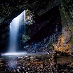
14.9 miles SE of Salt Lake City, UtahVery popular beginning hike in the Salt Lake City area. Many take this as a good intro hike into the outdoors, while others go for a trip out with friends to escape the rush of daily life. The donut name comes from the waterfall that flows into a cave through a hole in the cave ceiling. If visitors want to get a good view of the waterfall they need to be prepared to get wet in the process.
Starting at a parking lot, visitors can follow a trail that will take them to a cave where, once they climb up and into it, will be greeted by the lovely Donut Falls. The climb into the cave is not too difficult. Visitors should just be careful of slick rocks from the stream as the climb into the cave of Donut Falls. Sometimes people want to climb on top of the cave roof and try to get a picture of the donut fall from the top down. This is not advised and trying to climb on the top has caused several fatalities in recent years.
Overall the hike is a great hike for families and friends. In the summers the parking lot and trail can get very crowded as everyone likes to visit this cave. If going, consider going in the morning and on a weekday, which will cut down on the amount of people on the trail. The trail is relatively short, about 3 miles round trip, though remember to bring water and a camera to capture the pleasant nature around you.
The forested trail is well marked. The trailhead is in Big Cottonwood Canyon near the Jordan Pines picnic area.

Y-Mountain Summit Trail
Provo, Utah
2.8 miles E of Provo, UtahY Mountain is located directly east of Brigham Young University (BYU) in Provo, Utah, United States. The Slide Canyon/Y Mountain Trail leads to a large block Y located 1.2 miles (1.9 km) from a parking area at the mountain's base. This hillside letter was built over a hundred years ago as the insignia for BYU. For years the trail to the Y has been one of the most hiked trails in Utah Valley and provides a beautiful view of Provo and Orem, the rest of the many cities in Utah Valley and Utah Lake. The trail is also regularly used by hikers, bikers, paragliders and hunters to access the backcountry in the Slide Canyon area.
The large white Y on the side of the mountain has become the nationally recognized insignia for BYU and the reason why BYU is often called "the Y". It is made of concrete and is 380 feet high and 130 feet wide (116 by 40 m). The Y is even larger than the "Hollywood Sign" in Los Angeles.
There are 14 strands of lights placed around the perimeter of the Y, which are lit five times a year by the Intercollegiate Knights. It is lit for Freshman Orientation, Homecoming, Y Days, and graduation in April and August.

Fifth Water Hot Springs
Provo, Utah
19.0 miles SE of Provo, UtahAKA Diamond Fork Hot Springs
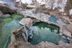
A beautiful drive and a 2.5 mile hike along the river will end you at an amazing set of hot springs that's well worth the trip. There's a variety of man-modified rock pools of varying temperatures up to 108°. Watch out for snakes. Depending on when you go, there can be a lot.
There are multiple sets of pools. As soon as you come into view of the falls, you'll see a couple of pools that seem to be a little raised above the creek. There are several pools close to the waterfall, including some very shallow pools and some where it's easy to move the rocks around to form your own. If you continue beyond the waterfall, you'll find a couple of more secluded pools. Make sure to go behind the waterfall but be careful of some of the more slippery rocks.
There's no good place to change once you get to the springs so you may want to plan to hike in your swimwear. If you come on a sunny day, it's easy to dry off before walking back. If you're a tenderfoot, be sure to bring some sort of footwear for the water so you can go wherever you like.
Like most locations, the hot springs more popular on the weekends so plan accordingly.
Roundtrip: 5 miles


