
Saratoga Hot Springs
Saratoga Springs, Utah
1.6 miles N of Saratoga Springs, UtahThe Saratoga Hot Springs are a wonderful place to visit in every season. The water is always around 100 degrees Fahrenheit, perfect for soaking away the winter cold. This is a wonderful place to spend hours with friends and family enjoying the beautiful trees, ponds and sunsets.
There are three separate pools at the Saratoga Hot Springs, all of which are heated from sources in their muddy bottoms. The largest is the most popular of the three, with the least muddy water. The area around the hot springs is wet and muddy most of the year. The state provides a bench and towel rack, but just in case you need more space it is smart to bring a tarp to keep your things on.
If you desire a break from these welcoming, warm waters, Utah Lake is a short hike away on clearly marked and well kept trails. Once there, you can enjoy a few relaxing moments watching the birds and other wildlife.
The Saratoga (or Inlet) Hot Springs are easily accessible via the short, cement trail located at Inlet Park, where parking and restrooms are provided.
The natural warmth and beautiful sights the hot springs provide will make your visit an event to remember.

Meadow Hot Spring
Meadow, Utah
5.4 miles W of Meadow, UtahThe springs are located on private property but the owners have been gracious enough to allow public access. As always, please be gracious respectful in return and if you pack it in, pack it out. There are three pools with varying degrees of warmth. There are also fire pits on the banks. The pools are very deep and are great for diving.
White Pine Lake
Sandy, Utah
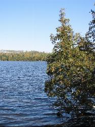
8.5 miles E of Sandy, UtahWhite Pine Canyon has long been the subject of intense controversy between advocates of wilderness and ski resort owners. The original boundaries of Lone Peak Wilderness Area, created in 1977, were meant to include White Pine Canyon, but lobbyists representing Snowbird Ski Resort succeeded in having White Pine Canyon excluded. Hike this fantastic canyon and discover why everyone wants it. This trail is open to mountain bikes but they are extremely rare. This is an easy hike but a real grind on a mountain bike.
Civil Defense Caves
Rexburg, Idaho
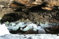
23.0 miles N of Rexburg, IdahoThe caves are large lava tubes. The name comes from the cold war era when they were anticipated as a safe area in the case of an attack. The entrance is pretty bouldery and does require a small amount of agility. Once in, it's easy enough for even little kids. Off the entrance, there are two main tubes. The right is pretty easy, the left is a little more difficult but does have bats. The right tube is mostly a flat gravely floor with a very large arched ceiling with rocks and boulders here and there. There's plenty of room to run around. College kids often play glow in the dark tag and other similar night games out here. It's pretty well patroled due to the high interest. At the end is a little more like caverns that you can crawl around through.
The caves are pretty cold year round. You're even likely to find some ice near the entrance. You'll want to bring jackets, lights, and good footwear. Sadly there is quite a bit of broken glass throughout the caves.
The dirt road up to the caves is very rocky and often washed out. You probably want to drive something with pretty good clearance.
The caves are closed October through April to protect the bat habitat.
West Thumb Geyser Basin
Grant Visitor's Center, Yellowstone National Park
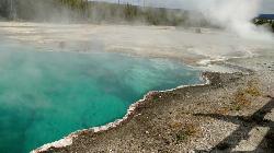
1.8 miles NW of Grant Visitor's Center, Yellowstone National ParkWest Thumb Geyser Basin is one of the smaller geyser basins in Yellowstone, yet its location along the shore of Yellowstone Lake and is ranked as the most scenic. This area was formed by volcanic explosion that took place more than 150,000 years ago. After the volcano exploded, the area collapsed and filled with water over time. It gets its thermal abilities from the enclosed magma trapped in the ring fractures that developed over time.In the 1990's several underwater geysers were discovered. These geysers can be seen as bulges underground, especially during the summer months. The basin is also special because of its location in Yellowstone. The West Thumb Geyser Basin is located on the edge of Yellowstone Lake.
This area features many other springs in the area. As surprising as it is, this area is also one of the least visited areas within Yellowstone. There are boardwalks all along the basin, making it an easy walk to see the beautiful hydrothermal springs in the area. West Thumb's name is derived from the thumb-like projection of Yellowstone Lake and the name was given by the 1870 Washburn Expedition. It was also known as Hot Spring Camp. West Thumb has less geyser activity than other basins. However, amazingly for its size it has all — hot springs, pools, mud pots, fumaroles and lake shore geysers.

Old Faithful Geyser
Old Faithful, Yellowstone National Park
0.0 miles SW of Old Faithful, Yellowstone National ParkOld Faithful is a cone geyser located in Yellowstone National Park in Wyoming, United States. It was named in 1870 during the Washburn-Langford-Doane Expedition and was the first geyser in the park to receive a name. It is a highly predictable geothermal feature, and has erupted every 44 to 125 minutes since 2000. The geyser and the nearby Old Faithful Inn are part of the Old Faithful Historic District.Courtesy of en.m.wikipedia.org
Grand Prismatic Spring Overlook Trail
Old Faithful, Yellowstone National Park
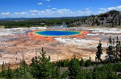
3.8 miles N of Old Faithful, Yellowstone National ParkThe Grand Prismatic Spring Overlook Trail gives hikers an opportunity to see the famous aerial view of the Grand Prismatic Spring. The vibrant rainbow waters of the Grand Prismatic Spring are best viewed from above.
The forested trail provides for a invigorating, short hike up to the overlook. From the overlook hikers have a sweeping view of the entire Midway Geyser Basin. Seeing this active geothermal area from above provides a unique perspective that you don't want to miss. This geyser basin is famous for the variety of color that can be seen here.
The Grand Prismatic Spring Overlook Trail is a 1.2 mile out and back hike that can be completed in less than 2 hours. The trail has some steep incline to get to the viewing point, but most hikers can tackle the hike. This trail is open in the winter, summer and fall, and closed in the spring. This hike is one of the more popular hikes in Yellowstone, so hikers will not be hiking alone.
The trailhead is located in the Fairy Falls Parking Lot, one mile south of the Midway Geyser Basin.
The Grand Prismatic Spring Overlook Trail is the best trail to take for view of the Grand Prismatic Spring and Midway Geyser Basin.
Cress Creek Nature Trail
Rexburg, Idaho
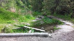
11.9 miles S of Rexburg, IdahoMeandering along the scenic South Fork of the Snake River, the beautiful 1¼ mile Cress Creek Nature Trail will lead you on a journey through sagebrush-grass communities, over juniper covered slopes, and along a lush perennial creek. Cress Creek derives its name from the watercress plant, a favorite food of the moose that live in this area. With clear skies, prepare for an expansive view of the Snake River, volcanoes and farmland. The site offers ample parking, restrooms and trail accessibility, which attract a wide spectrum of trail users to the area. You will become familiar with life in the Cress Creek area as it is now and as it was long ago. If you hike quietly you may see deer, rabbits, small lizards, or possibly an eagle or a moose. The nature trail is self-guided with many beautiful interpretive signs posted along the way to assist you. The first half-mile of the trail is accessible by wheelchair.
On the northeastern corner of the trail, there's an overlook trail. Parts of it are pretty nice like the rest of the loop but some is barely recognizable as a trail. Parts of the trail are steep and parts of it go over some pretty loose rock. It goes for about a ½ mile all the way to the top of the hill. Just below the rim, there are several really cool caves. From the top, you can see from Rexburg to Idaho Falls.
Provo Canyon
Provo, Utah
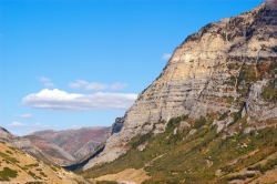
7.6 miles N of Provo, UtahProvo Canyon is a canyon located in unincorporated Utah County, Utah, USA and Wasatch County, Utah. Provo Canyon splits between Mount Timpanogos on the north and Mount Cascade on the south. The canyon extends from Orem on the west end to Heber City on the east. The canyon's main thoroughfare is U.S. Route 189. Attractions in Provo Canyon include Vivian Park and Bridal Veil Falls. The Heber Valley Historic Railroad operates passenger trains through the canyon. The Provo River has carved out the canyon over time along with the forces of erosion.


