30.5K Scouts 2 by endovereric
first prev 1 next lastUsing a compass and map together, take a 5-mile hike (or 10 miles by bike) approved by your adult leader and your parent or guardian.
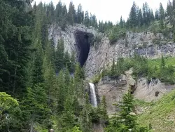
Darby Wind Cave
Driggs, Idaho
7.6 miles E of Driggs, IdahoDarby Wind Cave is a beautiful hike full of waterfalls, wildflowers, streams, and mountainous views. The sites you see will depend on the time of year you visit but it will always be beautiful and just a little bit of a challenge.
The trail starts out relatively flat, following along close to where the old road used to run. There are a few creek crossings which will vary in difficulty depending on how much snow there was over the winter and how long it's been since things began to thaw. Late summer will usually find you crossing dry or nearly dry creek beds. If you hike when runoff is high, there are log bridges. You don't have to be highwire ready but one of the bridges will take a little bit of balance. The trail turns up South up into the canyon. About as soon as it starts to go up, you'll turn and begin a series of switchbacks (10 turns). These will take you up the East wall of the canyon.
The switchbacks are not incredibly steep but you'll gain elevation pretty quickly. After the switchback, the trail follows along a rim above the canyon where you can look across the canyon and see two beautiful waterfalls and mouth of the cave seemingly high overhead. At the South end of the canyon, you'll come across a rock overhang. It's fun at any time during the summer but earlier when the water is higher, you'll find a little waterfall and stream that the kids will love to play in and you'll be hard pressed not to soak your head and feet and cool off a bit yourself.
From the the overhang, the hike continues West along the South end of the canyon through some more forest and a beautiful meadow. Take a minute to look up from the trail to enjoy the view of Fossil Peak to the South. Just after the meadow, you'll begin another series of switchbacks up to the falls and cave. The first set (2 turns) will take you up to a dispersed campsite and monument. The next leg will take you to the creek where you can look up and get photos of the falls and cave. The next set puts you out just underneath a very large and beautiful waterfall that drops out over a ledge. The ledge itself is a popular repel accessible from above. You can walk all the way around these falls and even catch some spray on the downwind side. The next set of switchbacks are stairs cut out of the rock. Halfway will take you to an even better view of Fossil Peak and the remainder will take you to the mouth of the cave itself. To enter the cave, you'll have to cross one more creek which can be pretty scary and dangerous when the water is high. Entering the cave during high water can be just as scary.
Once you're in, the Wind Cave snakes through the Darby Formation, a thick layer of 350 million year-old dolomite. A flashlight for the cave is a definite must. Near the mouth, there's a series of ledges popular for bouldering. Just up about 100 yards, you'll come to a small hole you'll have to crouch to get through. You'll quickly realize why they're called the wind caves as you're blasted with wind from the caves coming out that hole. After about 200 yards, you'll want your climbing gear. The caves stretch for miles and if you go far enough, you'll enter the part known as the ice caves. Travel far enough, you'll come out the other side. Be careful though. The cave becomes pretty cavelike and it's really easy to get lost and, even in the busy season, it may be days until that nightmare ends with a rescue team.
The hike is about 3.1 miles from the South Fork Darby Canyon trailhead to the caves and is a 1,800 feet elevation gain. You'll find a lot of resources that claim the hike is a shorter distance. These sources either begin from the end of the old road or don't take into account one or both series of switchbacks. The cave itself sits at 8,940 feet above sea level.
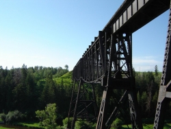
Ashton to Tetonia Trail
Ashton, Idaho
0.7 miles NE of Ashton, IdahoThe Idaho Department of Parks and Recreation undertook the project to transform the old Teton Valley Branch of the Union Pacific Railroad from Ashton to Tetonia into a trail for bikes, ATVs, and snowmobiles, runners, cross-country skiers, and horses. The trail goes from Ashton to Tetonia and can be accessed via Ashton, Marysville, Bitch Creek, Felt, or Tetonia. Information can be found at kiosks in Marysville and at Bitch Creek.
Elevation Gain (Southbound): 787 ft
Length: 29.6 mi

Aldous Lake and Hancock Lake
Kilgore, Idaho
7.7 miles N of Kilgore, IdahoA pair of alpine lakes near Kilgore, Idaho. Good road all the way to the trailhead. Easy to moderate 1.5mi hike to the first lake (Aldous) and another mile of moderate hiking to Hancock. Beautiful scenery, but heavier traffic on weekends.
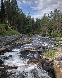
Box Canyon Trail
Island Park, Idaho
1.2 miles SW of Island Park, IdahoVarious species of tress and wildflowers can be seen on the trail, as well as songbirds, waterfowl and occasional wildlife. The trail is open for the following uses: Motorcycle Trail Riding, Off Highway Vehicles (OHV) less than or equal to 50 inches wide. source: fs.usda.gov Courtesy of Singletracks.com
This is a very scenic singletrack that can be ridden in either direction. There is not a lot of climbing but you get to enjoy beautiful views of the river as you follow it for the majority of the trail. The first part of the trail has a few spots that are rocky and can be a little harder to navigate through but this ends after about the first mile or so.Courtesy of MTBProject.com
This trail is a fly-fisherman’s dream, providing access to the trout-filled waters of Henry’s Fork of the Snake River. Beginning at the campground, the trail wanders south along Box Canyon’s rim for 3 miles, bringing hikers to the river after passing through a colorful wildflower landscape. Best months for hiking are June through September.Courtesy of ultimateidaho.com
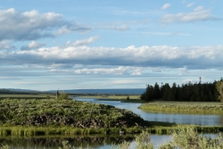
Harriman State Park
Island Park, Idaho
8.3 miles SW of Island Park, IdahoHarriman State Park is found 38 miles from Yellowstone along Henry's Fork. This 11,000-acre wildlife refuge is open year round for most activities. In addition to having beautiful scenery and wildlife, the area also has several houses that were built when the park was a privately owned ranch. The area is home to one of the best fly-fishing streams in the country, an eight mile portion of Henry's Fork river. There are many activities here including horseback riding, hiking, tours of the ranch, and fly-fishing.
During the summer, the trails through Harriman are a great place to hike and explore. There are plenty of wildflowers growing and the lakes and rivers flow nicely. Visitors will be able to see plenty of small wildlife, including swans on Silver lake, and there might even be a chance to see a moose or a bear. Part of the park crosses into the Caribou-Targhee National Forest. Along the river, there are beautiful views of the Tetons and the Yellowstone Plateau.
In the winter, the park is home to more than 24 miles of Nordic ski trails. The trails all vary in level of difficulty and distance. Most of the trails will go around Silver Lake and loop back towards the ranch houses. Other winter activites include fat biking and snowshoeing. The ranch houses are great in the winter because several have large fireplaces to warm up by.
The ranch houses can be rented out by visitors and have different accommodations for each house. Some of the houses include large gathering areas great for large groups of people. During different seasonns of the year the park offers events for the general public including star gazing and music camps.
This is an Idaho State Park and there are day use fees. Passes have reciprocity with Mesa Falls State Park which is only about 20 minutes away.
Buckskin Morgan Ridge
Ririe, Idaho
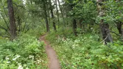
9.0 miles E of Ririe, IdahoGoing up is a little tough because of the rocks, but once you clear the top it is a twisty down hill portion [until] you get to a fenced road. From there you can turn around or keep going strait and follow the snowshoe trail back to an unkempt road [which] will lead back down to the main Kelly canyon road. If that is the case hang a right when you get to the main road and pedal up hill till you get to the parking area. I recommend gong back down the hill to get some really bumpy DH though ***watch for roots and rocks if you go back to the parking area via the morgan trail**** Courtesy of Singletracks.com
Climb from the Hawley/Buckskin parking area to the top of Buckskin Morgan Ridge. The trail has several steep climbs before getting to a rolling hill section that leads you to a dirt road. The trail starts from Road 218, heads into the trees and then up the hill. There is a sign on your right as you start your first climb. You'll encounter plenty of roots on the first climb. Shortly after that, the trail will again have another climb as you head north and west. The second climb is marked by plenty of loose rocks. Once on top of this section, you'll weave your way through the trees and down the hill to an intersection with the road. Courtesy of MTBProject.com

Webster's Dam
Ririe, Idaho
9.8 miles NE of Ririe, IdahoAlso known as Manmade Falls or the Woodmansee Dam, Webster Dam is an abandoned dam located deep in Moody Creek canyon, the dam was abandoned when sediment built up behind the dam which then caused the stream to split and flow around both sides of the dam, creating two beautiful waterfalls each about 15 feet in height. This makes a fun evening trip and is good for almost any time of the year as well. It's beautiful in the spring with powerful falls from the spring runoff and in the fall, there are plenty of fall colors along the pole line trail and around the waterfalls. At the falls, you'll find two waterfalls coming over each end of the dam. On the south end of the dam there is a bridge that spans the creek on that side. There is a little island in the middle where you can sit on the rock wall and take in the whole scene.
There are two trails which weave back and forth a couple of times so you can really choose your route a little bit. The main parking area is at the top of the hill by pole line and that's also the most common trailhead. The pole line trail follows the ATV road with several ups and downs. For the most part its a fairly rounded out and bermed double track awesome for mountain bikes and ATVs. For much of it, there's a hiking trail that follows along the side of it. However you travel this trail, be very aware of other riders and hikers which can seem to appear out of nowhere. The trail continues along the power pole lines for just over 3/4 miles, then turns left just as the balls on the power lines come into view. After a couple hundred feet, you'll see the other trail merge into this one from the left and then take off again to the right about 150 yards later. Keep left on the "pole line trail" for a more gradual decent or go right on the "wooded trail" for a more adventurous and much steeper route. The pole line trail go out and hook back taking you straight to the falls.
The wooded trail trailhead is Northwest of the pole line trail. It's a less used ATV track that goes back and forth between the woods and the pole line until it merges with the pole line trail about 3/4 miles in, only to split to the right 150 yards later. In another 100 yards, you'll come across another junction; keep left. In another 150 yards it will come back together with the pole line trail and continue all the way to the falls. On the upper portions, this trail is has a lot fewer ups and downs making it a more gradual hike. After merging with the pole line trail though, this trail becomes the much steeper option.
Whichever of these 2 paths you choose, the last 1/3 mile descent is more like a chunky forest road than the double track above. It has some pretty steep parts, some chunky rock sections, and some rollers that make great mountain bike jumps. While it's a little steep and chunky, most intermediate riders should be able to handle it just fine. At the bottom just before the falls are some very large dirt jumps off to the side. The last 30 yards to the falls after the dirt jumps is much more janky, probably more like a black diamond on a bike but not too tricky to get down on foot.
The third option is much longer, starting at the warming cabin on Brown's Road. It's an intermediate trail to the creek and then a green (easy) trail along the creek to the dam.
A very popular route to do this on a mountain bike is to loop it starting either at the warming cabin or the top of the pole line and riding down the pole line to the waterfall and then out Mad Cow and up Cabin Climb to complete the loop.
This can be a great family hike. Plan on 2-4 hours to hike it with little ones, depending on how fast and tough they are.
Jenny Lake Trail
Jackson Hole, Wyoming
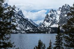
19.7 miles N of Jackson Hole, WyomingOne of the most popular trails to visit in Grand Teton is the Jenny Lake Trail. The Jenny Lake Trail, located near Moose, Wyoming, is an easy trail that loops around the lake. Along with the sheer beauty of Jenny Lake and surrounding mountains, some of the main attractions on this hike are Hidden Falls and Inspiration Point.
The trail underwent significant changes in 2018 after a fissure opened up and rock slides became an issue. The temporary changes made at that time, including trail reroutes and closures, have been undone and the lower trail is now open again taking onlookers all the way to Hidden Falls once again. The trail has been well built including hundreds of nicely placed stone stairs that keep the trail solid and provide great footing where you need it most.
Wildlife is common on the trails, including plenty of chipmunks, marmots, moose, deer, elk, and even an occasional bear. The best spot to see a moose or bear is often the overlook down to the Moose Pond Trail. You'll see a sign for the trail off to the left just a little ways before you get to the overlook. Even if you don't see any wildlife there though, the view of the ponds and Teewinot rising above is worth taking a break for. Other than this little jaunt over to the overlook and the hike up to Hidden Falls and Inspiration Point, the trail follows along the river for most of the way making any break you take a picturesque scene to enjoy.
The sunrise and sunset at Jenny Lake are incredible with radiant colors and exciting reflections off the water. Take a dip in Jenny Lake to cool off during summer months but remember that this is pretty fresh snow runoff so it may be colder than you think. For a little warmer swim, check out String Lake just to the North.
Between the soaring Tetons above, the falls above the trail, the raging river below the trail, and the expansive view of the lake and valley, there are plenty of great views to take in whether you see any wildlife or not.


