30.5K East Idaho Kid Hikes by endovereric
first prev 1 next last
Sheep Falls on Henry's Fork
Island Park, Idaho
15.6 miles S of Island Park, IdahoSheep Falls cascades approximately 25' through a narrow basalt chute on the North Fork of the Snake River near Island Park, Idaho. Compared to nearby Lower and Upper Mesa Falls, that height may not sound particularly spectacular but it is a pleasant hike on a relatively well maintained trail and is rarely crowded.
Pine Butte / The Caldera
St. Anthony, Idaho
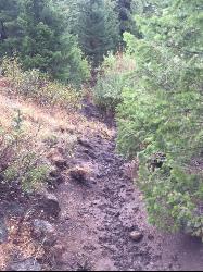
21.7 miles N of St. Anthony, IdahoThis is about as close to an oasis as you can get in the deserts of Idaho. It's an old volcano in the middle of the sagebrush desert. As soon as you start down the path, you can feel the air change and the vegetation becomes that of a mountain forest. There are a ton of pine trees on the hillsides and a beautfiul meadow at the bottom surrounded by thick aspen trees. The bottom part of the sides nearly all the way around is covered with large boulders great for a little rock hiking if you care to explore. The path in is about as easy a hike as it gets. Maybe a little steep at points but it's only about a quarter mile down in. It's pretty small and there's a pretty established place for fires with plenty of dead wood scattered around.
Mesa Falls
Ashton, Idaho
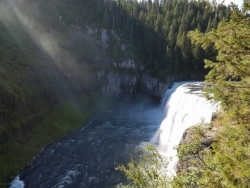
10.0 miles NE of Ashton, IdahoUpper Mesa Falls, aka Big Falls, is an absolutely awesome waterfall on the Henrys Fork of the Snake River. The falls drop 114 ft. and measure 300 ft. across. To get to the falls from the parking lot is 0.2 miles of paved walkway and several sturdy stairs with plenty of gaurdrails and handrails. There are several platforms along the route for viewing and taking photos. Catch it in the morning to see the rainbows in the lingering mist that often rises well above the platforms. There's a wheelchair accessible path that can get a pretty good view of the falls but does not go right down to it.
Lower Mesa Falls is about a mile down river from the Upper Falls. There's two great viewing options. One is from a cliff hovering 200 feet above the falls and the other is from the the Observation Site sitting 0.25 miles away and almost 500 feet above the falls. To get to the cliff above the falls, there's a trailhead on the South East end of the main parking lot. The trail is 1 mile each way (2 mile out and back) with about a 100 ft. difference in elevation (about the same as the stairs the the Upper Falls platforms). The trail goes through the woods well away from the river itself but there are no guardrails at the end when you're peering over the edge of the cliffs to see the waterfall. To see the falls from the observation site is free and the walk from your car to the lookout is only about 500 ft.
This is an Idaho State Park and there are day use fees. Passes have reciprocity with Harriman State Park which is only about 20 minutes away. Get there before 5pm to check out the old inn which has been transformed into a fun and informative visitor's center.

Sheep Bridge Trail
Driggs, Idaho
6.7 miles NE of Driggs, IdahoThis is a great easy trail for beginner hikers or mountain bikers. In the early summer, you'll find many beautiful wildflowers and large kaleidoscopes of butterflies to go with them. You may want to wear bright colors and walk slowly to entice the butterflies to land on you. There's often a wide variety so may even want a book to identify them all.
The new trailhead is just off Teton Canyon Road and has parking for 15-20 vehicles. From there, you'll follow the trail about 0.25 miles south to Teton Creek where you'll cross a bridge. After crossing the bridge, you'll find a short uphill but after that, the ascent is minimal. The trail is pretty easy to follow as long as you keep right and keep heading East. Just short of halfway, there's a nice little spot where the trail forks left and you can go down and take a break at the creek. The entire trail runs about 2.25 miles, running parallel to Teton Creek and ending at a creek just short of Treasure Mountain Scout Camp. If you're on a bike, that's where it gets fun. Turn that bike around and enjoy some easy but fun downhill singletrack.
Harriman State Park
Island Park, Idaho
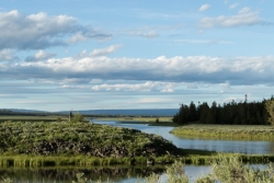
8.3 miles SW of Island Park, IdahoHarriman State Park is found 38 miles from Yellowstone along Henry's Fork. This 11,000-acre wildlife refuge is open year round for most activities. In addition to having beautiful scenery and wildlife, the area also has several houses that were built when the park was a privately owned ranch. The area is home to one of the best fly-fishing streams in the country, an eight mile portion of Henry's Fork river. There are many activities here including horseback riding, hiking, tours of the ranch, and fly-fishing.
During the summer, the trails through Harriman are a great place to hike and explore. There are plenty of wildflowers growing and the lakes and rivers flow nicely. Visitors will be able to see plenty of small wildlife, including swans on Silver lake, and there might even be a chance to see a moose or a bear. Part of the park crosses into the Caribou-Targhee National Forest. Along the river, there are beautiful views of the Tetons and the Yellowstone Plateau.
In the winter, the park is home to more than 24 miles of Nordic ski trails. The trails all vary in level of difficulty and distance. Most of the trails will go around Silver Lake and loop back towards the ranch houses. Other winter activites include fat biking and snowshoeing. The ranch houses are great in the winter because several have large fireplaces to warm up by.
The ranch houses can be rented out by visitors and have different accommodations for each house. Some of the houses include large gathering areas great for large groups of people. During different seasonns of the year the park offers events for the general public including star gazing and music camps.
This is an Idaho State Park and there are day use fees. Passes have reciprocity with Mesa Falls State Park which is only about 20 minutes away.
Conant Creek Pegram Truss Railroad Bridge
Ashton, Idaho
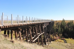
5.0 miles SE of Ashton, IdahoAs part of the Rails to Trails project, this old railroad bridge has been transformed into a very safe little viewing experience for the whole family. You can drive right up to the bridge where there is a great little spot to park. Conant Creek meeanders hundreds of feet below the bridge. It's about 300 yards across and whether you're taking in the vibrant colors of spring, the beautiful fall colors, or the Tetons looming in the background, the view is spectacular.
The bridge is part of the 30 mile Ashton-Tetonia Trail. There is a smaller bridge less than 2.5 miles north on the trail.

Henry's Fork Green Way (St. Anthony Green Belt)
Saint Anthony, Idaho
0.6 miles SW of Saint Anthony, IdahoThis is a great walk along the river. While it is nestled right next to the highway, the closeness and beauty of the river flowing on the other side of the trail more than make up for it. Halfway along the trail, there's a statue of Andrew Henry and a loop that will take you right back for an easy 1 mile. The full length is a mile itself making a full 2 mile round trip.
Pet Friendly: Yes
Difficulty: Easy
Trail: Paved
Length:
- Statue Loop: 1 mile
- Full Round Trip: 2 miles
Cress Creek Nature Trail
Rexburg, Idaho
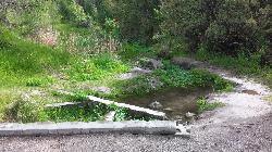
11.9 miles S of Rexburg, IdahoMeandering along the scenic South Fork of the Snake River, the beautiful 1¼ mile Cress Creek Nature Trail will lead you on a journey through sagebrush-grass communities, over juniper covered slopes, and along a lush perennial creek. Cress Creek derives its name from the watercress plant, a favorite food of the moose that live in this area. With clear skies, prepare for an expansive view of the Snake River, volcanoes and farmland. The site offers ample parking, restrooms and trail accessibility, which attract a wide spectrum of trail users to the area. You will become familiar with life in the Cress Creek area as it is now and as it was long ago. If you hike quietly you may see deer, rabbits, small lizards, or possibly an eagle or a moose. The nature trail is self-guided with many beautiful interpretive signs posted along the way to assist you. The first half-mile of the trail is accessible by wheelchair.
On the northeastern corner of the trail, there's an overlook trail. Parts of it are pretty nice like the rest of the loop but some is barely recognizable as a trail. Parts of the trail are steep and parts of it go over some pretty loose rock. It goes for about a ½ mile all the way to the top of the hill. Just below the rim, there are several really cool caves. From the top, you can see from Rexburg to Idaho Falls.

Sheep Falls on Fall River
Ashton, Idaho
17.7 miles E of Ashton, IdahoThe lesser known Sheep Falls on Fall River is a local treasure off of Cave Falls road. There are primitive campsites and beautiful views for a great picnic spot. The water splits and comes down in multiple places creating a unique set of waterfalls.
Idaho Falls Greenbelt
Idaho Falls, Idaho
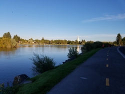
0.5 miles NW of Idaho Falls, IdahoThe Idaho Falls Greenbelt is one of Idaho Falls charms located in the heart of Idaho Falls, next to the historic Idaho Falls downtown. The paved foot-trail is approximately 6 miles around, following the river plus brings you past the hotels and some of restaurants in Idaho Falls. The trail is enjoyed by bicyclists, joggers or pedestrians who just want to relax and check out the sites beside the 22 foot waterfall, stretching over 600 feet wide. You cross the Broadway Bridge (on the west bank) to get a great view of the entire length of the falls. The path takes you down Riverside Drive, through the South side of downtown Idaho Falls, past the War Veterans Memorial, past a scenic viewing area, alongside fisherman's park, and more.
| Broadway to John's Hole & Around | 2.3 miles |
| John's Hole to Freeman Park | 0.4 miles |
| Around Freeman Park | 1 mile |
| Broadway to Pancheri & Back | 1.4 miles |

North Menan Butte ('R' Mountain)
Menan, Idaho
4.5 miles N of Menan, IdahoThe North Menan Butte is more commonly known to the locals and college students as R Mountain. Many kids know it better as Ou'R' Mountain. The butte is a rare and unique geological area and provides a great volcanic hike.
There's a paved parking lot and a vault toilet at the West trailhead. The first few hundred yards are well-maintained gravel and sand paths and the further you get, the less defined the trail gets, though it is relatively easy to find and follow. The switchback trails (South and West) are marked by sections of log fences. Towards the top of the West switchbacks, there's a chain handrail. It gets a little steep so you'll want some shoes with some grip. The sand on the rock makes it pretty slippery in the steeper parts. You'll get better grip after a good rain. Once you get up to the top, there's an informational placard. From there, it's easy to hike the rim and get an awesome view of the valley including Rexburg, Henry's Fork, and the Snake River.
It's a great hike for a small family or just a quick hike for a date. Even going up the West switchbacks and around rim, including the 'R', and back down the same way is only 3.5 miles (longest route) so you can do it pretty quick if you want. There's so much to look at that you could also spend hours climbing rocks, exploring caves, and playing around "The Ampitheater". If you just want to get to the 'R' as quickly as possible, you can do the hike in as little as 2 miles roundtrip.
Distances:
- West trailhead up the face to the rim: 0.5 miles
- West trailhead up the switchbacks to the rim: 0.75 miles
- West trailhead, from reaching the rim to 'R': 1 mile
- South trailhead to the rim: 0.3 miles
- South trailhead, from reaching the rim to 'R': 0.75 mile
- Through the caldera: 0.6 miles
- Around the rim: 2 miles
- Rim to 'R': 500 feet
There are no fees. Camping is allowed up to 5 nights but fires must be in an elevated fire pan and all the ash must be packed out.
Posted regulations:
- No motorized vehicle use
- Discharging of weapons or fireworks is prohibited
- Open fires are permitted only with an approved elevated fire pan and ash removal
- Burning pallets, tires, wire, plastic, glass, metal, magnesium, or hazardous material is prohibited
- Cutting or damaging vegitation is prohibited
- 5-day camping limit


