


Refine Search
- hike 36
- mountain bike 22
- swim 12
- disc golf 10
- horseback 6
- camp 5
- skateboard 4
- kayak 3
- hot springs 3
- canoe 3
- cave 1
- rock climb 1
- canyoneer 1
- whitewater 1
- snowshoe 1
- dive 1
60 locations
Add Location
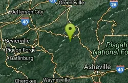


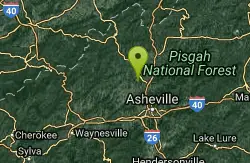

Sliding Rock
Hot Springs, North Carolina
2.3 miles S of Hot Springs, North CarolinaSliding Rock is a well loved destination in the Pisgah National Forest. This 60 foot natural rock waterslide descends into an 8 foot deep pool, creating a unique adventure. The water is between 50...
Swim 0.6 mi
Packsaddle Lake
Tetonia, Idaho
9.3 miles W of Tetonia, IdahoPacksaddle is one of the less well known lakes/trails in the area. If you've got a good offroad vehicle, you can probably make it all the way to the end of the road, otherwise, it's just an...
Dive, Hike, Mountain Bike, Snowshoe, Swim 6.0 mi
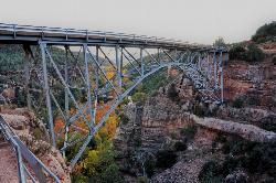
Huckaby Trail
Sedona, Arizona
0.7 miles E of Sedona, ArizonaOn the hunt for adventure? Established in 1998, Huckaby Trail is just the adventuresome route for both avid hikers and mountain bikers. It offers up forestry of Arizona Sycamores and picturesque...
Canoe, Hike, Mountain Bike 1.4 mi
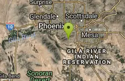
Mohave Trail (#200)
Phoenix, Arizona
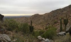
7.1 miles NE of Phoenix, ArizonaAn invigorating swift hike is what Mohave Trail 200 provides for anyone looking for a free and quick escape. Though the main attraction of the Phoenix Mountain’s Preserve is the larger Piestewa...
Hike, Horseback 0.8 mi
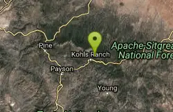
Promontory Butte
Payson, Arizona
17.1 miles NE of Payson, ArizonaThis destination is on the edge of Promontory Butte, providing spectacularly scenic views as part of the Mogollon Rim. There are several old forest roads on the mountain that can serve as trails to...
Hike 8.5 mi
Munds Wagon Trail
Sedona, Arizona
3.1 miles E of Sedona, ArizonaMunds Wagon Trail is different from many of the other more “classic†rides around Sedona. If you come from somewhere else and are missing the feel of loose rocks...
Hike, Mountain Bike 2.2 mi
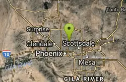
Piestewa Peak Summit Trail #300
Phoenix, Arizona
7.0 miles NE of Phoenix, ArizonaSome people still refer to the Peak by its original name of "Squaw Peak" before its name changed to "Piestewa Peak" in honor of Lori Piestewa who died serving her country in the...
Hike 3.8 mi
Freedom Loop Trail (#302)
Phoenix, Arizona
6.9 miles NE of Phoenix, ArizonaFreedom Trail (#302), also known as Piestewa Circumference, is a 3.8 mile, moderate loop trail. You can access this trail from all the inner trailheads. The easiest and least...
Hike 1.9 mi
Ruth Hamilton Trail
Phoenix, Arizona
7.7 miles NE of Phoenix, ArizonaHike and Mountain Bike near Phoenix, Arizona
Hike, Mountain Bike 4.6 mi
Perl Charles Memorial Trail (#1A)
Phoenix, Arizona
6.7 miles N of Phoenix, ArizonaThis is a technical singletrack loop with some very steep up and down sections located in the Phoenix Mountain Preserves. This trail is for advanced riders who like to bleed and leave their skin on...
Hike, Horseback, Mountain Bike 0.2-5.0 mi
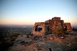
Holbert Trail to Dobbins Lookout
Phoenix, Arizona
6.7 miles S of Phoenix, ArizonaStart out at the main entrance to South Mountain and make a left past the vistor's center. Go to the end of the road to the beginning of Holbert Trail. Get to the top and make a right to Dobbins...
Hike 0.8-1.0 mi
Kiwanis Trail to Telegraph Pass Lookout
Phoenix, Arizona
7.4 miles S of Phoenix, ArizonaAn ideal hike to take children on as the distance is short and the elevation gain is not extreme. Avid hikers have opportunities to embark on longer hikes into South Mountain. ... This short hike is...
Hike, Mountain Bike 4.9 mi
Tempe Town Lake Trail
Tempe, Arizona
0.8 miles N of Tempe, ArizonaOn the lake's south side, the trail connects Arizona State University's main Tempe campus with Tempe Beach Park, as well as the Tempe Marketplace retail mecca. A newer extension on the...
Hike 2.0 mi
Loma and Canal Trails
Tempe, Arizona
0.8 miles N of Tempe, ArizonaTrails open to mountain biking and hiking that wind through the Papago Park in Tempe, Arizona. The Loma Trail winds around lots of uphill and downhill paths, and leads to a park with a small lake and...
Hike, Mountain Bike 2.1 mi
Marcos de Niza & Pima
Phoenix, Arizona
7.8 miles SE of Phoenix, ArizonaIf you're looking to: get off the tourist highway trail, enjoy killer South Mountain views, take a rollercoaster for a hike with an easy stroll or jog back to the start - this is a loop you...
Hike 6.1 mi
Goat Hill via Telegraph Pass Trail
Phoenix, Arizona
9.1 miles S of Phoenix, ArizonaThe views from the top of Goat Hill are awesome on a clear day as you can enjoy a 360 view. Telegraph Trail is kind of a sidewalk part of the after that a little bit rocky until you reach the summit...
Hike 1.3 mi
Dreamy Draw Loop Trail
Phoenix, Arizona
8.4 miles N of Phoenix, ArizonaThe Dreamy Draw Nature Trail is a short multi-access loop trail that provides a true Sonoran Desert experience. The trail crosses a number of desert washes and, at times, becomes somewhat rocky....
Hike, Horseback, Mountain Bike 3.4 mi
Alexander Mountain Bike Park
Alexander, North Carolina
1.4 miles N of Alexander, North CarolinaNice, challenging singletrack. Not overly technical, with some nice climbs and nice flowing sections, and a nice view of the French Broad river. However, this trail does get overgrown sometimes from...
Hike, Horseback, Mountain Bike 0.2-2.3 mi
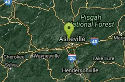
Richmond Hill
Asheville, North Carolina
2.7 miles NW of Asheville, North CarolinaHilly, wooded course. Handmade signs and Astro Turf tees. Alt. pins on 14 holes. Long pants smart (poison ivy). Parking lot OB. Public (No Fee) Richmond Hill Park is Asheville's largest wooded...
Disc Golf, Hike, Mountain Bike 5.4 mi
Denton Trail #69
Tonto Basin, Arizona
3.9 miles S of Tonto Basin, ArizonaFrom FR 421, the trail climbs steadily up the east face of the mountain. Some sections are quite steep. The trail eventually tops out at 5,760 feet elevation and then descends to Big Pine Flat for...
Hike, Mountain Bike
×


