


152 Things to do near Island Park, Idaho
Showing results within 50 miles Distance miles of Island Park, ID, USA City, Zip, or Address
Buffalo River Campground
Island Park, Idaho
0.5 miles NEThe float here is nice and easy. It's a great early season float. Later in the season the shallow spots will force you to walk a good chunk of the float. The water is super clear and often pretty...
Camp, Canoe, Kayak, Swim 5.8 mi
Box Canyon Trail
Island Park, Idaho
1.2 miles SWVarious species of tress and wildflowers can be seen on the trail, as well as songbirds, waterfowl and occasional wildlife. The trail is open for the following uses: Motorcycle Trail Riding, Off...
Hike, Mountain Bike
Box Canyon Island Park
Island Park, Idaho
1.3 miles SWThe Box Canyon Campground is situated on the canyon rim above the Henry's Fork of the Snake River. There are 16 single and 2 double units, each having tent and camper pads, fire rings, grills...
Canoe
Coffee Pot Rapids Trail
Island Park, Idaho
4.6 miles NHiker and fisherman parking is available at the campground entrance. Coffee Pot Rapids trail is 2.2 miles in length, is a non-motorized trail that follows the Henry's Fork of the Snake...
Mountain Bike
Upper Coffee Pot Campground
Island Park, Idaho
4.6 miles NUpper Coffeepot Campground stretches along a floatable section of Henry's Fork of the Snake River. A mixed growth lodgepole pine forest provides partial shade and summer wildflowers are...
Camp, Canoe
Boundary Trail
Island Park, Idaho
5.6 miles NEBoundary Trail, (Trail #272 and #244) is a 37 mile loop trail that allows stock travel, mountain bike, motorcycle and ATV travel. This trail can be reached by several trailheads,...
Mountain Bike
Big Springs
Island Park, Idaho
7.6 miles NEThere's also a great little walking trail along the river with placards that tell about the ecosystem and history of the area. There's about a 1/2 mile that's paved and then a 1/2 mile...
Camp, Hike 0.6-4.7 mi
Harriman State Park
Island Park, Idaho
8.3 miles SWHarriman State Park is found 38 miles from Yellowstone along Henry's Fork. This 11,000-acre wildlife refuge is open year round for most activities. In addition to having beautiful scenery and...
Cross-country Ski, Hike, Horseback, Mountain Bike, Snowshoe 7.6 mi
Mount Jefferson
Island Park, Idaho
9.7 miles NMount Jefferson, at 10, 203 feet is the highest point in the Centennial Mountains, a small, local range on the border of Idaho and Montana a little west of Yellowstone. These mountains consist of a...
Hike 4.2 mi
Lake Marie
Island Park, Idaho
9.7 miles NLake Marie sits on the North slope of Mount Jefferson in Fremont County, Idaho. The trail to get there cuts back and forth across the Idaho Montana border 4 times. Much of the trail is fairly flat...
Backpack, Hike
Sawtell Peak Trail
Island Park, Idaho
9.7 miles NThis trail offers great views of the valley floor, mountain peaks and wildlife. source: fs.usda.gov
Mountain Bike
Flat Canyon Trail
Island Park, Idaho
13.5 miles SENon-motorized use. souce: fs.usda.gov
Mountain Bike
Big Bend Ridge Trail
Ashton, Idaho
15.5 miles SWTrail is open to OHVs. source: fs.usda.gov
Mountain Bike
Sheep Falls on Henry's Fork
Island Park, Idaho
15.6 miles SSheep Falls cascades approximately 25' through a narrow basalt chute on the North Fork of the Snake River near Island Park, Idaho. Compared to nearby Lower and Upper Mesa Falls, that height may...
Hike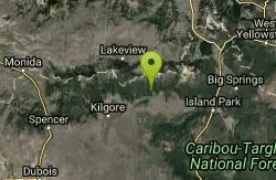
Howard Creek Trail
Island Park, Idaho
15.9 miles WThe Howard Creek trail follows Howard Creek upstream to the old Taylor Creek Road. The old Taylor Creek Road connects the Howard Creek trail to the Continental Divide Trail. Howard...
Mountain Bike
Mesa Falls
Ashton, Idaho
16.5 miles SUpper Mesa Falls, aka Big Falls, is an absolutely awesome waterfall on the Henrys Fork of the Snake River. The falls drop 114 ft. and measure 300 ft. across. To get to the falls from the parking lot...
Cross-country Ski, Hike, Kayak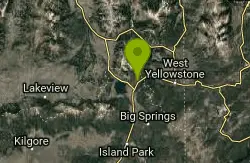
Targhee Creek Trail
Island Park, Idaho
17.3 miles NSpecial attractions along the trail include five alpine lakes amid the mountains, abundant wildlife, wildflowers, and great scenic views of the mountains and valley floor. The Targhee...
Mountain Bike
Ashton Hill
Ashton, Idaho
18.2 miles SFairly thick forest. Considerable underbrush. Lots of places in the area to play.
Airsoft, Paintball 17.5 mi
Tear Drop Lake
Ashton, Idaho
18.3 miles SENestled in the Targhee National Forest just off of Ashton's Fish Creek Road, this tear drop shaped lake is a family adventure waiting to happen. The lake isn't very big but it is teeming with...
Camp, Canoe, Hike, Kayak, Mountain Bike, Swim
The Pit
Ashton, Idaho
19.1 miles SThis location is great because there is no one around only locals know of this area and you can shoot anything out there. Watch out for target shooters there! Also stay away from the main road.
Airsoft, Paintball 0.3-0.6 mi
Bear Gulch
Ashton, Idaho
19.3 miles SBear Gulch is an abandoned ski hill out of operation since 1969. While the vegetation is beginning to take over, there's still some great sledding to be had. It's just far enough into the...
Camp, Cross-country Ski, Hike, Sled
Sand Creek Frenzy
Ashton, Idaho
19.7 miles SWThere are some woods back there and it is secluded. There are many places you can play just watch out for campers.
Paintball
Divide Road
Island Park, Idaho
19.7 miles NDivide Road criss-crosses the Continental Divide between Montana and Idaho. I have ridden it three times and didn't see a soul each time. I saw lots of deer and elk. There are bears...
Mountain Bike
Rendezvous Loop
West Yellowstone, Montana
20.7 miles NEGentle rolling hills that wind though tall stands of lodgepole pine and open meadows. Easy ride with great potential for speed.
Mountain Bike 1.3 mi
Riverside Bike Trail
West Yellowstone, Montana
21.1 miles NEJust inside Yellowstone's West Entrance is a short and stunning mountain bike trail that shouldn't be missed. Riverside Bike Trail is a gravel and dirt trail that leads through the forest to...

Warm River Campground
Ashton, Idaho
21.2 miles SWarm River Campground is located nine miles northeast of Ashton, Idaho, along the slow-moving Warm River at an elevation of 5,200 feet. Willows line the riverbanks and pine trees offer partial...
Camp 3.2-47.0 mi
Yellowstone Branch Line Trail
Ashton, Idaho
21.2 miles SYellowstone branch line trail runs from Warm River to the Montana border totaling 39 miles. There are a few places to jump on and off the trail as well as a few smaller trails that branch off of this...
Backpack, Cross-country Ski, Hike, Horseback, Mountain Bike 14.8 mi
Biscuit Basin to Fairy Falls and Firehole Meadows
Old Faithful, Yellowstone National Park
22.2 miles EFreight Road trail is a almost 15 mile hike that leaves from Biscuit Basin or Fountain Flats Drive. This hike is a beautiful remote hike that passes several unique landmarks, breaking up this hike...
Backpack, Camp, Hike
Horseshoe Lake
Ashton, Idaho
22.5 miles SEHorseshoe Lake is hidden back in the Targhee National Forest. It's a beautiful lake with plenty of lily pads. The road to get there is well maintained and there are many options for pull-outs...
Camp, Canoe, Dive, Swim
Mile Creek Trail
23.7 miles N
It is important to note that Mile Creek Trail is part of the Continental Divide Trail system, so it connects to other trails of various difficulties. Mile Creek Trail itself is a great...
Mountain Bike 4.8 mi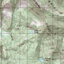
Aldous Lake and Hancock Lake
Kilgore, Idaho
23.9 miles WA pair of alpine lakes near Kilgore, Idaho. Good road all the way to the trailhead. Easy to moderate 1.5mi hike to the first lake (Aldous) and another mile of moderate hiking to Hancock. Beautiful...
Backpack, Camp, Hike, Horseback, Swim 29.6 mi
Ashton to Tetonia Trail
Ashton, Idaho
24.3 miles SThe Idaho Department of Parks and Recreation undertook the project to transform the old Teton Valley Branch of the Union Pacific Railroad from Ashton to Tetonia into a trail for bikes, ATVs, and...
Mountain Bike
Porcupine Creek
Ashton, Idaho
24.4 miles SPorcupine Creek is a hunting, fishing, camping, and swimming spot near Ashton, Idaho in Fremont County within Targhee National Forest. It's surrounded by forests, meadows, and a creek...
Camp, Swim
Cliff Lake
Cameron, Montana
24.8 miles NCanoe and Kayak near Cameron, Montana
Canoe, Kayak 14.8-30.2 mi
Mr. Bubbles Hot Spring
Old Faithful, Yellowstone National Park
24.9 miles SEMr. Bubbles is one of the few places you can actually soak in the thermal waters of Yellowstone National Park. The Bechler area of Yellowstone is one of the best kept secrets of the otherwise densely...
Hike, Hot Springs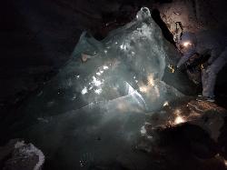
Rexburg Area Ice Caves
Rexburg, Idaho
24.9 miles SWNot to be mistaken with the Civil Defense Caves (which are near by), the Ice Caves are about an hour North outside of Rexburg. The Ice Caves were originally formed as lava tubes. The shape of the...
Cave
Pine Butte / The Caldera
St. Anthony, Idaho
24.9 miles SWThis is about as close to an oasis as you can get in the deserts of Idaho. It's an old volcano in the middle of the sagebrush desert. As soon as you start down the path, you can feel the air...
Camp, Hike, Horseback
Falls River, Lower Run
Ashton, Idaho
25.4 miles SFall River rises on the Madison and Pitchstone plateaus in the southwest corner of Yellowstone National Park, Wyoming and flows approximately 64 miles (103 km) to its confluence with the Henrys Fork...
Whitewater
River Rush
Ashton, Idaho
25.4 miles SPaintball near Ashton, Idaho
Paintball 0.3-0.5 mi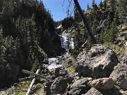
Mystic Falls
Old Faithful, Yellowstone National Park
25.9 miles EMystic Falls is a 70-foot cascading waterfall on Little Firehole River. The area around the falls is quiet and beautifully forested. Mystic Falls is a lesser known spot in Yellowstone National Park....
Hike


