


25 Things to do near Baker City, Oregon
first prev 1 2 next lastShowing results within 50 miles Distance miles of Baker City, OR 97814, USA City, Zip, or Address
Marble Pass Trailhead
Baker City, Oregon
9.7 miles WThe Marble Pass Trailhead is located on the southern end of the Elkhorn Crest National Recreation Trail in the Elkhorn Mountain range west of Baker City. The small site is very rustic...
Mountain Bike
Phillips Lake Southern Bike & XC Ski Trails
Baker City, Oregon
11.1 miles SWThere are several dual purpose summer and winter trails located south of Phillips Lake that offer a variety of recreation opportunities. In the winter these trails are open for cross...
Mountain Bike
Southeast Shore Phillips Lake
Baker City, Oregon
11.7 miles SWThe Southeast Shore Phillips Lake Trailhead is a small minimally developed facility located across Mason Dam on the southeast side of Phillips Lake. The facility offers year-round...
Mountain Bike
Radium Hot Springs
Haines, Oregon
11.9 miles NWHot Springs near Haines, Oregon
Hot Springs
Social Security Point
Baker City, Oregon
12.1 miles SWThe Social Security Point Trailhead is located in an open ponderosa pine forest above the northern shore of Phillips Lake. Although the area is used by many visitors, it is also a...
Mountain Bike
Twin Lakes
Baker City, Oregon
12.5 miles WThe Twin Lakes Trailhead is a small facility located on the southern end of the Elkhorn Mountains. This is the lower access route into Twin Lakes. This facility has no amenities and is...
Mountain Bike
Phillips Lake South Shoreline Trail #1610
Baker City, Oregon
13.0 miles SWThe Phillips Lake South Shoreline trail begins on the south side of Mason Dam and ends near Southwest Shore Campground. The trail traverses the southernly banks of the lake (actually a...
Mountain Bike
Dean Creek
Baker City, Oregon
13.3 miles SWThe Dean Creek Trailhead is a small facility located on the south side of Phillips Lake. It one of several trailheads or areas available to access the Phillips Lake South Shoreline...
Mountain Bike
Elkhorn Crest National Recreation Trail #1611
Baker City, Oregon
13.4 miles WThe Elkhorn Crest Trail (#1611) was established as a National Recreation Trail in 1979. It is the highest trail in the Blue Mountains and runs along the Elkhorn Mountain ridgeline...
Mountain Bike
Phillips Lake North Shoreline Trail #1608
Baker City, Oregon
14.0 miles SWThe Phillips Lake North Shore trail traverses the northern banks of Phillips Reservoir connecting Mason Dam Boat Launch, Union Creek Campground, Social Security Point, Mowich Loop to a...
Mountain Bike
Kropp Hot Springs
North Powder, Oregon
16.6 miles NHot Springs near North Powder, Oregon
Hot Springs
Fisher Hot Springs
Haines, Oregon
17.2 miles NWCLOSED. Land and spring are on private land with No Trespassing signs posted.
Hot Springs
Medical Springs
Baker City, Oregon
19.5 miles NEHot Springs near Baker City, Oregon
Hot Springs
North Powder River / Trail #1632
Baker City, Oregon
20.2 miles WLight use trail open to mountain bikes.
Mountain Bike
Blackeye / Trail #243
36.0 miles W
This trail leads to Vinegar Hill-Indian Rock Scenic Area. Its high use period is in the fall during big game hunting seasons. via fs.usda.gov
Mountain Bike
Eastern Oregon University
La Grande, Oregon
39.7 miles NPlays throughout college campus. All concrete walking paths are OB. #1-8 play in the sports complex. #3-6 are in a field located behind the armory and #7 and 8 play back out behind the old baseball...
Disc Golf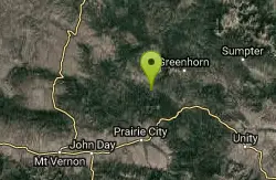
Davis Creek / Trail #244
Prairie City, Oregon
41.6 miles WThe majority of the trail is in moderate to heavy timber with only a few scenic vistas. Evidence of old mining and timber activities are visible from the trail.The roads to the southern...
Mountain Bike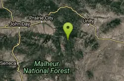
Horseshoe / Trail #363
Prairie City, Oregon
42.8 miles SWThe trail begins as a narrow dirt road, narrowing to a shared use trail after about 3/4 of a mile. You may encounter motorized users.The trail climbs abruptly up and continues to be...
Mountain Bike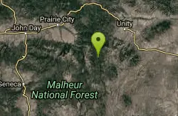
Sheep Creek / Trail #371
Prairie City, Oregon
44.0 miles SWThis shared use trail follows along Sheep Creek. The trail is mostly timbered offering scenic views of the area at the top. Carry water or treatment method to avoid contamination. This...
Mountain Bike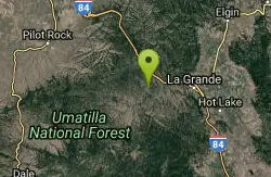
Spring Creek
La Grande, Oregon
44.8 miles NWThe Spring Creek Bike Trail Loop A (#B-100) is one of four bike trails in the Springs Creek area. The trail is 7.5 miles long and makes an outer loop through the rolling ponderosa pine...
Mountain Bike


