


236 Things to do near Timpanogas Cave
first prev 1 2 3 4 5 6 7 8 9 10 next lastShowing results within 50 miles Distance miles of 2038 Alpine Loop Rd, Provo, UT 84604, USA City, Zip, or Address
Rodeo Down
Alpine, Utah
2.7 miles WBlack Dog. Trail winds from the middle of Corkscrew down to Flank and River, just south of the water tank. Some technical aspects, length 0.5 miles with 300 vertical feet elevation...
Mountain Bike
Bear Canyon Loop
Provo, Utah
3.3 miles EA route for the thrill seeker, the Bear Canyon Loop is an advanced mountain biking route. This a challenging route and should be done only by those who know how to handle their bike on steep rocky...
Mountain Bike
Timpanooke
Provo, Utah
3.6 miles EThis is a great trail. Intermediate tech and moderate aerobic. It winds through pine forests and grass meadows. Start by heading down the Timpanooke section of the Great Western Trail...
Mountain Bike 1.6-14.1 mi
Mount Timpanogas
Provo, Utah
3.6 miles EMt. Timp, as the locals call it, is the 2nd highest mountain in the Wasatch range (only Mt. Nebo is higher). What sets "Timp" apart is its location. It towers over the Provo, Orem, Pleasant...
Camp, Hike, Horseback, Swim 1.7 mi
Schoolhouse Springs Trail
Alpine, Utah
3.9 miles NWSchoolhouse Springs trail has an elevation trail at 5,300 ft. It's located at the end of the town of Alpine. It features a lake and there's a number of activities including horse-back...
Hike, Mountain Bike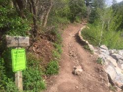
Tibble Fork
Provo, Utah
4.1 miles NEThis trail is advanced tech and strenuous aerobic. This trail involves a few miles of riding on the pavement. Start by heading back down to the intersection with the South Fork of American Canyon and...
Mountain Bike
Tibble Fork Reservoir
Provo, Utah
4.2 miles NEThere isn't one specific sledding run at this location. There's a great parking lot and hills above and below. It all depends on what kind of speed and excitement you're looking for....
Sled
Grove Creek Trail
Pleasant Grove, Utah
4.7 miles SThe Grove Creek Trail falls from the upper shoulder of Mount Timpanogos down Grove Creek Canyon to Pleasant Grove. It's usually ridden as a shuttled downhill -- because the climb up this...
Hike, Mountain Bike
Bonneville Shoreline Trail - Cedar Hills to Grove Creek Canyon
Pleasant Grove, Utah
4.8 miles SThe Cedar Hills to Grove Creek Canyon portion of the Bonneville Shoreline Trail is an intermediate level trail. There are some flat spots that are on old dirt roads, as well as single track...
Mountain Bike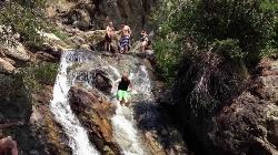
Alpine Rock Water Slide
Alpine, Utah
4.8 miles NWCLOSED. The land has been sold and the new owner has closed off the waterslide to the public. The Alpine Waterslide is a natural waterslide that surprisingly does not hurt your backside. However,...
Swim
Ridge Trail #157
Provo, Utah
4.9 miles EThis trail is 15.7 miles in length and is commonly referred as the backbone of the American Fork Canyon trail system, because it connects several loop routes along the northern portion of the...
Mountain Bike
Beacon Hill Park Disc Golf
Highland, Utah
5.0 miles WIncredible views of Utah Valley, Utah Lake, and the surrounding Rockies. Nestled on a large expanse of natural fields at the base of Hog Hollow Canyon, the course has a (usually) dry creek and a few...
Disc Golf
Art Dye Disc Golf Park
American Fork, Utah
5.5 miles SWTechnical with a variety of lengths. Plays mostly in trees with tight fairways and minor elevation. Tees are brick tiles, except #13 (rubber), and #12 and #15 (dirt). Course Map at 1st tee. Public...
Disc Golf
G Mountain Trail
Pleasant Grove, Utah
5.6 miles SThe trail starts at Kiwanis Park which is south of the 'G' at the end of Battle Creek Road. The trail starts out a little steep for about .25 mile and the very last bit is a...
Hike 1.2 mi
Battle Creek Falls
Pleasant Grove, Utah
5.6 miles SBattle Creek Falls, located near Pleasant Grove, Utah, is a scenic waterfall that also has a rappelling and rock climbing area nearby. Hikers are allowed to see the falls from two view points, below...
Canyoneer, Hike
Evergreen Park
American Fork, Utah
5.8 miles SWSled near American Fork, Utah
Sled
Stewart Falls
Provo, Utah
6.0 miles SEStewart Falls is found nestled in the forest along the east side of Mt. Timpanogos. Fed by a glacier on the mountain, the crystal clear falls will leave visitors refreshed on a warm summer day. Those...
Hike
Timpanogos Falls
Provo, Utah
6.1 miles SEOne of the many waterfalls in the Mt Timpanogos area, Timpanogos Falls is a lesser known and visited waterfall. The trail for Timpanogos Falls departs from the same parking lot as Stewart Falls,...
Hike
Shelley Elementary
American Fork, Utah
6.4 miles SWSled near American Fork, Utah
Sled
Mercer Hollow Trail
Draper, Utah
6.6 miles WMercer Hollow Trail is primarily used to bomb down the southern flanks of the ridge the Corner Canyon Trails sit on. It's filled with berms, rock features, rollers, and sweet, sweet...
Hike, Mountain Bike


