


237 Things to do near Rodeo Down
first prev 1 2 3 4 5 6 7 8 9 10 next lastShowing results within 50 miles Distance miles of 1250 E 300 N, Alpine, UT 84004, USA City, Zip, or Address
Schoolhouse Springs Trail
Alpine, Utah
1.7 miles NSchoolhouse Springs trail has an elevation trail at 5,300 ft. It's located at the end of the town of Alpine. It features a lake and there's a number of activities including horse-back...
Hike, Mountain Bike
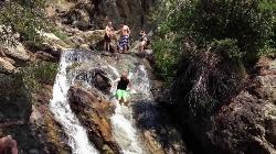
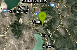
Alpine Rock Water Slide
Alpine, Utah
2.5 miles NWCLOSED. The land has been sold and the new owner has closed off the waterslide to the public. The Alpine Waterslide is a natural waterslide that surprisingly does not hurt your backside. However,...
Swim
Beacon Hill Park Disc Golf
Highland, Utah
2.5 miles WIncredible views of Utah Valley, Utah Lake, and the surrounding Rockies. Nestled on a large expanse of natural fields at the base of Hog Hollow Canyon, the course has a (usually) dry creek and a few...
Disc Golf 1.5 mi
Timpanogas Cave
Provo, Utah
2.7 miles EKnown for it's colorful cave decorations, the Timpanogas cave attracts numerous visitors per year, is steep but it's paved so that visitors can access the cave. To access the cave, visitors...
Backpack, Cave, Hike
Mercer Hollow Trail
Draper, Utah
3.9 miles WMercer Hollow Trail is primarily used to bomb down the southern flanks of the ridge the Corner Canyon Trails sit on. It's filled with berms, rock features, rollers, and sweet, sweet...
Hike, Mountain Bike 1.7 mi
Jacob's Ladder Trail
Sandy, Utah
4.1 miles NWJacobs Ladder trail has an elevation trail of 5,700 ft. and the most popular trailhead out of the five trails in Lone Peak. It's located near a large area on the right side of the road...
Hike, Mountain Bike 0.2-1.8 mi
Lone Peak
Draper, Utah
4.2 miles NWEstablished in 1978 and located southeast of Salt Lake, Lone Peak is one of the taller peaks in the Wasatch range along the Wasatch Front. It has 5 main trailheads: Jacobs Ladder via Corner Canyon...
Hike, Mountain Bike, Rock Climb 1.2 mi
Ghost Falls Trail
Sandy, Utah
4.2 miles NWGhost Falls is located in the corner canyon riding area of Draper, Utah and one of the first mountain bike routes in the canyon. It's a family-friendly hike, named for the...
Hike, Mountain Bike, Snowshoe 1.3 mi
Eagle Crest Trail
Draper, Utah
4.4 miles WEagle Crest trail is a beginner level trail mountain bike in Draper, Utah along the north side of Traverse Mountain. From the trail, riders can see the Salt Lake Valley, the Northern end of Utah...
Hike, Mountain Bike
Art Dye Disc Golf Park
American Fork, Utah
4.8 miles STechnical with a variety of lengths. Plays mostly in trees with tight fairways and minor elevation. Tees are brick tiles, except #13 (rubber), and #12 and #15 (dirt). Course Map at 1st tee. Public...
Disc Golf 0.6 mi
Potato Hill Trail
Draper, Utah
5.4 miles NWLocated in Draper, UT, Potato Hill Trail start at the trailhead on Transverse Mountain Road. and goes down to the (BST) or Bonneville Shoreline Trail west of Coyote Hollow. There are some trails that...
Hike, Mountain Bike
Little Valley Trail
Draper, Utah
5.4 miles WOne of the best places in the Salt Lake valley to take kids mountain biking is the Little Valley Instructional Trails. Fortunately, these superbly constructed “flow” trails are just as...
Hike, Mountain Bike
Shelley Elementary
American Fork, Utah
5.4 miles SWSled near American Fork, Utah
Sled
Evergreen Park
American Fork, Utah
5.5 miles SSled near American Fork, Utah
Sled 0.2 mi
Orson Smith trail
Draper, Utah
5.7 miles NWOrson Smith Trail is located north of the Corner Canyon Gate. It leads up to the suspension bridge and has become a popular spot for hiking and bike routes since the suspension...
Hike, Mountain Bike
300 East Lehi Lot
Lehi, Utah
5.8 miles SWThis is a huge lot with a lot of terrain. There's a couple of easily accessible hills and plenty more that could be played on.
Sled
Bear Canyon Loop
Provo, Utah
5.8 miles EA route for the thrill seeker, the Bear Canyon Loop is an advanced mountain biking route. This a challenging route and should be done only by those who know how to handle their bike on steep rocky...
Mountain Bike 0.8 mi
Red Rock Trail
Draper, Utah
5.8 miles WThe Red Rock trail located in Draper, Utah is a short loop trail just down the road from the Draper LDS Temple. The hike itself may be short, but since it is along the cliffs of the southern end of...
Hike, Mountain Bike, Rock Climb 0.6 mi
Bst To Equestrian Center Loop
Draper, Utah
5.8 miles NWAn intermediate trail with a length of 10 miles that's located in Draper, UT. It's a single track look trail that has an elevation of 417 ft. Start at the Equestrian Center and follow the...
Hike, Mountain Bike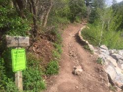
Tibble Fork
Provo, Utah
5.9 miles EThis trail is advanced tech and strenuous aerobic. This trail involves a few miles of riding on the pavement. Start by heading back down to the intersection with the South Fork of American Canyon and...
Mountain Bike


