


75 Things to do near Klonzo Area
first prev 1 2 3 4 next lastShowing results within 50 miles Distance miles of 2 5th W St, Moab, UT 84532, USA City, Zip, or Address
Prospector
Moab, Utah
0.5 miles NThe trail has both a high and low line, with the higher being the more difficult and slightly longer of the two options. The trail is singletrack cut into the side of the hill with...
Mountain Bike
Moab Brand Trails
Moab, Utah
0.8 miles EGreat introduction to Moab riding. Start at the parking area for Bar M Chuckwagon and follow the signs. Ride the loop in a counter-clockwise direction (Bar M, then Bar B to Rockin'A...
Mountain Bike
Slickrock
Moab, Utah
1.9 miles EThis trail is probably the most well known mountain bike trail in the country. That being said, it is not necessarily the BEST trail in the country. It is definitely unique due to the...
Mountain Bike
Portal Trail
Moab, Utah
2.0 miles WVery technical with extreme exposure. There are signs that say riders were killed on the trail - likely by falling over the cliff. Do not ride this from the bottom up, but use this...
Mountain Bike
Moab Rim
Moab, Utah
2.0 miles SWThis trail is a 3 mile connector to the Hidden Valley Trail. The trail follows a primitive slickrock road and has good views of the Colorado River, the Moab Valley, and the sandstone...
Mountain Bike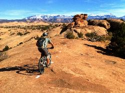
Slickrock Trail
Moab, Utah
2.3 miles EThese Moab trails are deceptively named for mountain bikes. This region was so named because the rock was slick for horseshoes. With mountain bike tires, you'll get insanely good grip that...
Mountain Bike
Wall Street
Moab, Utah
2.5 miles SWWall Street is an immense 500’ high Wingate sandstone cliff group located 10 minutes west of Moab across from the entrance to Arches National Park on Utah Highway 279 (aka Potash Road). It...
Rock Climb
Moab Area
Midway, Utah
2.8 miles NESwim near Midway, Utah
Swim
Fins n Things
Moab, Utah
3.0 miles EFins & Things is primarily a double-track loop ride off the Sand Flats Road about a mile past Slickrock. Terrain is varied, with rolling fins of sandstone and rough doubletrack on...
Mountain Bike
Amasa Back Area
Moab, Utah
3.5 miles SWThanks to the fantastic trails that have been built by Moab Trail Mix in recent years, the Amasa Back area is no longer a one-trick pony of a 4x4 road. Instead, it has been developed...
Mountain Bike
Jackson Trail
Moab, Utah
3.5 miles SWAfter climbing Amasa Back there is a trail on the right that will take you to Jackson's singletrack. This trail hugs the slickrock bench above the Colorado River and brings you to the...
Mountain Bike
Mill Creek Swimming Hole
Moab, Utah
3.6 miles EA couple of the best swimming holes in Southern Utah combined with a nice collection of petroglyphs make this one of Moab's premier warm weather hikes. Its amazing to see this lush paradise...
Swim
Hymasa
Moab, Utah
3.7 miles SWHymasa is a brand-new (as of spring 2014) two-way singletrack trail that bypasses the main Amasa Back climb in the Amasa Back Area trail system. The beauty of this route is...
Mountain Bike
Pothole Arch Trail
Moab, Utah
3.8 miles SWAfter climbing Amasa Back the trail forks off to the right. The singletrack will take you out and back to Pothole Arch and to the start of Rockstacker. Fun trail on slickrock and...
Mountain Bike
Amasa Back Trail
Moab, Utah
3.8 miles SWI dismissed this trail after first reading the description due to the elevation gain (aprox '1400) but a friend talked me into doing it and I am glad she did, what a great ride! This is...
Mountain Bike
Pipe Dream
Moab, Utah
3.8 miles SEA North/South route laced between the private property that is the town of Moab and the Moab Ridge standing on the west side of town. Skirting through the rough foothills below the...
Mountain Bike
Poison Spider Mesa
Moab, Utah
3.9 miles SWThis is a technically and physically demanding trail which can be done as a loop or an out and back. Those willing to take great risk can try their skills on the famous Portal Trail...
Mountain Bike
Captain Ahab
Moab, Utah
4.2 miles SWClimb up Amasa Back's rocky, ledge-filled jeep road for 2.7 miles. At 2.3 you'll see a sign for the Ahab mid-point. Keep climbing to reach the actual beginning. There's a sign and a...
Mountain Bike
Funnel (Cable) Arch
Moab, Utah
4.2 miles SWFunnel or Cable Arch is located outside of the Arches National Park in Moab, Utah. While many people will visit the famous Arches National Park, Funnel Arch is just as spectacular, but less...
Hike
Old City Park Disc Golf Course
Moab, Utah
4.3 miles SEBeautiful red rock setting with panoramic views of sandstone cliffs and big mountain peaks. It weaves through varied desert terrain dotted with pinyon pines and junipers. Public (No Fee)
Disc Golf


