242 Things to do near Horseshoe Lake
first prev 1 2 3 4 5 6 7 8 9 10 next lastShowing results within 50 miles Distance miles of Forest Rd 374, Ashton, ID 83420, USA City, Zip, or Address
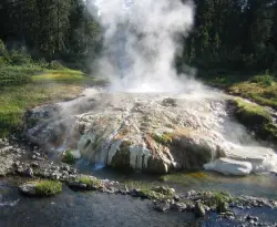
Mr. Bubbles Hot Spring
Old Faithful, Yellowstone National Park
2.9 miles EMr. Bubbles is one of the few places you can actually soak in the thermal waters of Yellowstone National Park. The Bechler area of Yellowstone is one of the best kept secrets of the otherwise densely...
Hike, Hot Springs 17.5 mi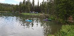
Tear Drop Lake
Ashton, Idaho
4.5 miles NNestled in the Targhee National Forest just off of Ashton's Fish Creek Road, this tear drop shaped lake is a family adventure waiting to happen. The lake isn't very big but it is teeming with...
Camp, Canoe, Hike, Kayak, Mountain Bike, Swim
Cave Falls of Yellowstone
Ashton, Idaho
5.3 miles EThis campgrond is situated on the banks of Fall River in Wyoming along the south border of Yellowstone National Park. Cave Falls Campground has 23 single site units and a terrific area for...
Camp, Hike
Sheep Falls on Fall River
Ashton, Idaho
5.6 miles SThe lesser known Sheep Falls on Fall River is a local treasure off of Cave Falls road. There are primitive campsites and beautiful views for a great picnic spot. The water splits and comes down in...
Camp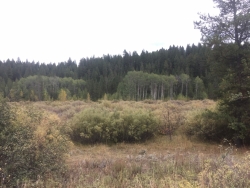
Porcupine Creek
Ashton, Idaho
7.8 miles SWPorcupine Creek is a hunting, fishing, camping, and swimming spot near Ashton, Idaho in Fremont County within Targhee National Forest. It's surrounded by forests, meadows, and a creek...
Camp, Swim 15.9-16.6 miUnion Falls & Ouzel Pool
Grant Village, Yellowstone National Park
8.2 miles EBackpack, Hike, Hot Springs, and Swim near Grant Village, Yellowstone National Park
Backpack, Hike, Hot Springs, Swim 1.1 mi
Fish Lake
Ashton, Idaho
8.2 miles EHike near Ashton, Idaho
Hike
Loon Lake
Ashton, Idaho
8.2 miles SECamp, Kayak, and Swim near Ashton, Idaho
Camp, Kayak, Swim
The Pit
Ashton, Idaho
9.1 miles WThis location is great because there is no one around only locals know of this area and you can shoot anything out there. Watch out for target shooters there! Also stay away from the main road.
Airsoft, Paintball 0.3-0.6 mi
Bear Gulch
Ashton, Idaho
9.2 miles WBear Gulch is an abandoned ski hill out of operation since 1969. While the vegetation is beginning to take over, there's still some great sledding to be had. It's just far enough into the...
Camp, Cross-country Ski, Hike, Sled
Flat Canyon Trail
Island Park, Idaho
9.2 miles NWNon-motorized use. souce: fs.usda.gov
Mountain Bike
Falls River, Lower Run
Ashton, Idaho
9.7 miles SWFall River rises on the Madison and Pitchstone plateaus in the southwest corner of Yellowstone National Park, Wyoming and flows approximately 64 miles (103 km) to its confluence with the Henrys Fork...
Whitewater
Warm River Campground
Ashton, Idaho
10.7 miles WWarm River Campground is located nine miles northeast of Ashton, Idaho, along the slow-moving Warm River at an elevation of 5,200 feet. Willows line the riverbanks and pine trees offer partial...
Camp 3.2-47.0 mi
Yellowstone Branch Line Trail
Ashton, Idaho
10.8 miles WYellowstone branch line trail runs from Warm River to the Montana border totaling 39 miles. There are a few places to jump on and off the trail as well as a few smaller trails that branch off of this...
Backpack, Cross-country Ski, Hike, Horseback, Mountain Bike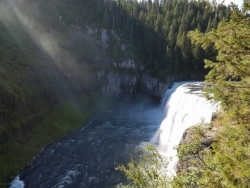
Mesa Falls
Ashton, Idaho
11.4 miles WUpper Mesa Falls, aka Big Falls, is an absolutely awesome waterfall on the Henrys Fork of the Snake River. The falls drop 114 ft. and measure 300 ft. across. To get to the falls from the parking lot...
Cross-country Ski, Hike, Kayak 1.9 mi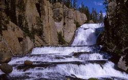
Terraced Falls
Grant Village, Yellowstone National Park
12.8 miles E3.6 mile easy out and back trail. 430 ft Elevation gain. The trailhead is off Ashton-Flagg Ranch Road along Yellowstone's South border. Ashton-Flagg Ranch Road is closed during the winter.
Hike
Bitch Creek Trestle
Tetonia, Idaho
14.7 miles SAs part of the Rails to Trails project, this old railroad bridge has been transformed into a very safe little viewing experience for the whole family. You can drive right up to the bridge where...
Hike
Sheep Falls on Henry's Fork
Island Park, Idaho
15.0 miles WSheep Falls cascades approximately 25' through a narrow basalt chute on the North Fork of the Snake River near Island Park, Idaho. Compared to nearby Lower and Upper Mesa Falls, that height may...
Hike 0.8 mi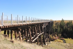
Conant Creek Pegram Truss Railroad Bridge
Ashton, Idaho
16.2 miles SWAs part of the Rails to Trails project, this old railroad bridge has been transformed into a very safe little viewing experience for the whole family. You can drive right up to the bridge where there...
Hike 29.6 mi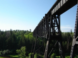
Ashton to Tetonia Trail
Ashton, Idaho
17.6 miles WThe Idaho Department of Parks and Recreation undertook the project to transform the old Teton Valley Branch of the Union Pacific Railroad from Ashton to Tetonia into a trail for bikes, ATVs, and...
Mountain Bike


