


46 Things to do near Cherry Springs
first prev 1 2 3 next lastShowing results within 50 miles Distance miles of 2 S Mink Creek Rd, Pocatello, ID 83204, USA City, Zip, or Address
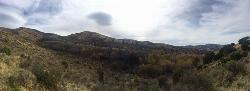
Kinney Creek Trail
Pocatello, Idaho
0.6 miles NKinney Creek Trail is in the Caribou-Targhee National Forest near Pocatello. This is a 6.4 out-and-back trail that takes you to the Indian Mountain Summit. It gives you views of Idaho...
Hike
Slate Mountain Trail
Pocatello, Idaho
1.4 miles SWTrail is open to cross-country skiing, snowshoeing, mountain biking, horse riding, hiking. source: fs.usda.gov
Mountain Bike
Valve House Draw
Pocatello, Idaho
2.3 miles SWThis trail is a motorized, doubletrack trail, as well as a great place to go hiking. For the most part, the trail is all uphill through a forest. There are some technical sections of the route as...
Cross-country Ski, Hike, Horseback, Mountain Bike
West Fork Mink Creek Trail
Pocatello, Idaho
2.4 miles SWA popular trail in the Eastern Idaho area for horseback riding, hiking, and mountain biking. The trail is a little over three and a half miles of single track riding. For the majority of the trail...
Hike, Horseback, Mountain Bike
South Fork Of Mink Creek Trail
Pocatello, Idaho
3.4 miles SWCross Country Ski, Hike, Mountain Bike, and Snowshoe near Pocatello, Idaho
Cross-country Ski, Hike, Mountain Bike, Snowshoe
East Fork Mink Creek Trail
Pocatello, Idaho
3.4 miles SWIf it's early in the season and you're anxious to dust off the skis, the East Fork Road is a good starting place. The East Fork road to Justise Park Rec Area joins the Bannock Highway about...
Cross-country Ski, Hike, Horseback, Mountain Bike
Slate Mountain/Gibson Jack Trail
Pocatello, Idaho
3.4 miles NWThe Gibson Jack trail offers great views of Southeastern Idaho and a favorite trail among moutain bikers. This trail is a continuation of the West Fork Mink Creek trail and takes travelers further...
Hike, Horseback, Mountain Bike
East Fork Crestline
Pocatello, Idaho
3.5 miles SEHead up the singletrack after about 0.6 miles look for a T which will take you to a paved road. Ride up the paved road by a campground and onto the East Fork ATV trail.East Fork ends...
Mountain Bike
Gibson Jack/west Fork
Pocatello, Idaho
3.7 miles NWThe West Fork is a mix of single/doubletrack with some fun rock spots and good scenery throughout. After climbing about 1500' in elevation, it's all downhill on singletrack on the...
Mountain Bike
Scout Mountain Campground
Pocatello, Idaho
4.4 miles SEScout Mountain Campground is located on beautiful Scout Mountain at an elevation of 6,900 feet, just 13 miles south of Pocatello, Idaho. Scout Mountain is part of the Mink Creek area, a popular...
Camp, Hike
Driveway Canyon Trail
Inkom, Idaho
5.5 miles EMotorcycle traili. source: fs.usda.gov
Mountain Bike
Sunnyside Cliffs at Ross Park
Pocatello, Idaho
6.1 miles NThe routes on the Sunny Side can be identified by a number at the bottom of the climbs. The number is close to where the rope should hang for a given climb. These numbers were put up years ago and...
Rock Climb
Shady Side Cliffs at Ross Park
Pocatello, Idaho
6.5 miles NThe routes on the Shady Side can be identified by a number on top of the cliff as well as on the face at the bottom of the climbs. The number is close to where the rope should hang for a given...
Rock Climb
Upper Ross Park
Pocatello, Idaho
6.6 miles NOn grass with elevation and large trees that force a variety of throws. Alt. pins throughout the seasons. Public (No Fee)
Disc Golf
Ross Park
Pocatello, Idaho
6.7 miles NOn grass with elevation and large trees that force a variety of throws. Alt. pins throughout the seasons. Public (No Fee)
Disc Golf 0.2-9.7 mi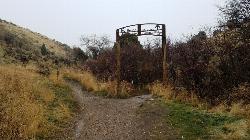
City Creek
Pocatello, Idaho
7.5 miles NThe City Creek Management Area (CCMA) Trail System is a vast network of trails maintained by the City of Pocatello. There are trails to go up and others to come down. Most trails come back to the...
Hike, Horseback, Mountain Bike
Bengal Ridge at ISU
Pocatello, Idaho
8.2 miles NChallenging desert course with extreme elevation changes and large scrubby junipers. . Public (No Fee)
Disc Golf
Cave Trail
Pocatello, Idaho
8.3 miles NMountain Bike near Pocatello, Idaho
Mountain Bike
Idaho State University
Pocatello, Idaho
10.1 miles NChallenging desert course with lots of elevation changes and large scrubby junipers. Public (No Fee)
Disc Golf
Sister City Disc Golf Course
Pocatello, Idaho
10.3 miles N7 short holes in the grassy park followed by 11 in surrounding natural terrain. Back 9 fairly long (one at 700'!) and has significant elevation. Multiple pin positions. Posts mark the tees. Best...
Disc Golf


