


214 Things to do near Big Bend Ridge Trail
first prev 1 2 3 4 5 6 7 8 9 10 next lastShowing results within 50 miles Distance miles of Forest Road 343, Ashton, ID 83420, USA City, Zip, or Address
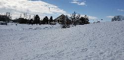
Teton Lakes Golf Course
Rexburg, Idaho
30.6 miles SWThis golf course is open year round, for golfing in the summers to cross country skiing in the winter. During the winter the course has over two miles of groomed cross country ski trails. You can...
Cross-country Ski, Sled 0.1-0.3 mi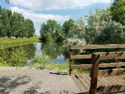
Rexburg Nature Park
Rexburg, Idaho
30.7 miles SWRexburg Nature Park: Life can be stressful, annoying, or just not good. Sometimes, it takes a moment to simply get away from the non-sense of this world; to gather yourself and seek peace and...
Disc Golf

Wright Creek Trail
Tetonia, Idaho
31.2 miles SOpen to MTB, horseback riding, snowshoeing, and hiking. source: fs.usda.gov
Mountain Bike
Badger Creek
Tetonia, Idaho
31.3 miles SEBadger Creek is a stream located just 13.6 miles from Ashton, in Teton County, in the state of Idaho, United States, near France, ID. Whether you’re spinning, baitcasting or fly fishing your...
Camp, Cross-country Ski, Hike, Mountain Bike, Rock Climb 0.1 mi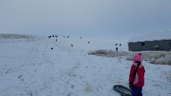
Founder's Square Hill (Under the Water Tower)
Rexburg, Idaho
32.2 miles SWThis is a great sledding hill. It's about the perfect steepness and really wide. It's also big enough to make it worth a little run on a snowboard or an inner tube. While this is a pretty...
Sled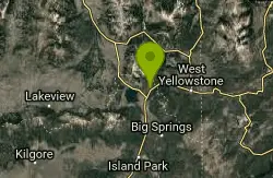
Targhee Creek Trail
Island Park, Idaho
32.2 miles NSpecial attractions along the trail include five alpine lakes amid the mountains, abundant wildlife, wildflowers, and great scenic views of the mountains and valley floor. The Targhee...
Mountain Bike 0.6 mi
Packsaddle Lake
Tetonia, Idaho
32.6 miles SPacksaddle is one of the less well known lakes/trails in the area. If you've got a good offroad vehicle, you can probably make it all the way to the end of the road, otherwise, it's just an...
Dive, Hike, Mountain Bike, Snowshoe, Swim
Divide Road
Island Park, Idaho
32.9 miles NDivide Road criss-crosses the Continental Divide between Montana and Idaho. I have ridden it three times and didn't see a soul each time. I saw lots of deer and elk. There are bears...
Mountain Bike
Beaver Dick Park
Rexburg, Idaho
33.8 miles SWBeaver Dick is a park 4.5 miles west of Rexburg, Idaho on Hwy 33. It's a 9.5 acre park that passes next to the west bank of the Henry Fork of the Snake River; it's a popular...
Camp, Canoe, Disc Golf, Swim 1.9 mi
Terraced Falls
Grant Village, Yellowstone National Park
34.1 miles E3.6 mile easy out and back trail. 430 ft Elevation gain. The trailhead is off Ashton-Flagg Ranch Road along Yellowstone's South border. Ashton-Flagg Ranch Road is closed during the winter.
Hike 14.8 mi
Biscuit Basin to Fairy Falls and Firehole Meadows
Old Faithful, Yellowstone National Park
34.1 miles NEFreight Road trail is a almost 15 mile hike that leaves from Biscuit Basin or Fountain Flats Drive. This hike is a beautiful remote hike that passes several unique landmarks, breaking up this hike...
Backpack, Camp, Hike
Probation And Burg Bumper
Tetonia, Idaho
35.1 miles SThe Probation part of the trail is the steepest downhill in the area. Has multiple bridges and log jumps in the short mile down. The Burg portion of the trail is uphill with some...
Mountain Bike
Rendezvous Loop
West Yellowstone, Montana
35.9 miles NEGentle rolling hills that wind though tall stands of lodgepole pine and open meadows. Easy ride with great potential for speed.
Mountain Bike 1.3 mi
Riverside Bike Trail
West Yellowstone, Montana
36.4 miles NEJust inside Yellowstone's West Entrance is a short and stunning mountain bike trail that shouldn't be missed. Riverside Bike Trail is a gravel and dirt trail that leads through the forest to...

Herbert Idaho Ghost Town
Ririe, Idaho
36.6 miles SCLOSED. Private property marked NO TRESPASSING. Herbert is a small ghost town that was operated until the 40s, but with the invention of the automobile, it was much more convenient to live in Rexburg...
Hike
Sharks Belly
Driggs, Idaho
36.6 miles STrail system can start from Channel lock or Bovine. Channel Lock is an easier climb than Bovine. This description and mileage starts at the Channel Lock trail, forest service boundary marker. Take...
Mountain Bike
Channel Lock
Driggs, Idaho
36.7 miles STrail is a little over 1 mile uphill. Recommended route up to access the larger Horseshoe canyon trail system. Makes a nice downhill with twists. Gets its name from the deep ruts made from cows....
Mountain Bike
Southbound
Driggs, Idaho
36.7 miles STrail starts by going up the Channel lock trail. At the top of Channel Lock go right onto the Southbound trail. Trail will loop back to Channel lock which you take back to your car. Trail is...
Mountain Bike
Horseshoe Canyon
Tetonia, Idaho
36.7 miles SHorseshoe Canyon is one of the closest trail systems to the town of Driggs, Idaho. This network doesn't have a ton of climbing or descending, but the smooth, swooping singletrack with a...
Mountain Bike
North Mahogany Trail #220
Tetonia, Idaho
36.8 miles She N. Mahogany Trail is open to Motorbikes, Mountain bikes, Horses, and Hikers. Motorbikes and Horseback riders are the most common visitors, but the trail is becoming increasingly...
Mountain Bike


