


75 Things to do near Arches NP Main Road
first prev 1 2 3 4 next lastShowing results within 50 miles Distance miles of Devils Garden Rd, Moab, UT 84532, USA City, Zip, or Address
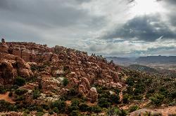
Fiery Furnace
Moab, Utah
3.2 miles SEA fun place to go hiking within Arches National Park. The Fiery Furnace area is a permit only area, with several ranger-led tours available. Hiking permits are required in order to enter, as well...
Hike
Miner's Loop
Moab, Utah
6.3 miles WMiner's Loop is a brand-new (as of April 2014) advanced loop near the Klondike Bluffs south trailhead. This entertaining trail climbs to the top of a bluff and then is a rip-roaring...
Mountain Bike
Baby Steps
Moab, Utah
6.4 miles WNewer singletrack in Moab. It follows the Klondike Bluffs trail for a bit, then spurs off. It is well signed. A combination of a little doubltrack, slickrock, and singletrack. The...
Mountain Bike
Sovereign Single Track
Moab, Utah
7.0 miles SWThe Sovereign trail is a part of the Sovereign trail system in Moab, Utah. This trail is a mix of slickrock and nice singletrack trail. At the beginning of the trail there will be an uphill climb...
Mountain Bike
Salt Wash
Moab, Utah
7.0 miles SWSalt Wash is a much more technical route compared to the other, neighboring trail Sovereign. The Salt Wash trial includes both a mix of flowy singletrack as well as some more technical slickrock....
Mountain Bike
Mega Steps
8.6 miles W
A fun trail built as a section of the Klondike Bluffs system utilized to complete a loop out of Baby Steps - EKG or Little Salty. From the trailhead there is a short sandy section to...
Mountain Bike
Monitor & Merrimac/Courthouse Pasture
Moab, Utah
8.7 miles SWGreat trail, did this ride while on a guided tour in 2004. There are some great scenery views along the trail including dinosaur bones, wildlife, rock formations along with slickrock...
Mountain Bike
Klondike Bluffs
9.6 miles W
The Klondike Bluffs area is now a complex trail system featuring a myriad arrangement of 4x4 roads and singletrack/slickrock bikes-only trails. These trails climb the sides of the...
Mountain Bike
Maverick
Moab, Utah
9.7 miles SWThe Maverick trail is a short .4-mile flowy, dirt singletrack trail that connects to North 40 on both ends. When I first road at Moab Brand I initially dismissed this short section, but...
Mountain Bike
Bar M Loop
Moab, Utah
9.9 miles SWThis trail is easy, it is an excellent one to introduce a newcomer to our sport and the riding found around Moab (I took my 11yr old son and he had a blast, he wants to keep going back...
Mountain Bike
Rockin' A
Moab, Utah
9.9 miles SWThis trail is part of the Moab Brands Mtn. Bike Trails and connects to other trails in the system. There are various ways to reach Rockin' A. Grab a map or check out the maps posted at...
Mountain Bike
Deadman's Ridge
Moab, Utah
10.0 miles SWNot a fast trail by any means, Deadman's Ridge is probably the most technical trail of this network so far. A mix of slickrock and hard pan this is a great option for those riders...
Mountain Bike
North 40
Moab, Utah
10.0 miles SWThe North 40 is a mix of rock and dirt singletrack. Rocky sections are fun to climb and descend and include painted marks to show the way. Great for advanced and advanced intermediate...
Mountain Bike
Circle O Trail
Moab, Utah
10.0 miles SWIt is 100% slickrock, on top of Entrada sandstone. Once you get in there, you will see the painted bike tire trail marker. Some sections the painted trail marks has worn and blended...
Mountain Bike
Hidden Canyon-blue Hills Loop
10.6 miles W
The trail makes a loop utilizing the Hidden Canyon 4x4 road and other 4x4 roads and the Blue Hills road. Trail is best ridden as a clockwise route. A downloaded GPS track to your GPS...
Mountain Bike
Bartlett Wash
11.2 miles SW
The trail is easy aerobic and can be as technical as you like. The official trail is fairly short but there is plenty to explore. Follow the trial west and then cruise along the North...
Mountain Bike
Moab Area
Midway, Utah
12.5 miles SSwim near Midway, Utah
Swim
Gold Bar Rim
Moab, Utah
13.4 miles SJeep trail that has sand and many step ups. Follow the signs and cairns. Follow the blue dots, or the Gold Spike jeep trail after you reach the rim. You can connect this trail to...
Mountain Bike
Portal Trail
Moab, Utah
13.7 miles SVery technical with extreme exposure. There are signs that say riders were killed on the trail - likely by falling over the cliff. Do not ride this from the bottom up, but use this...
Mountain Bike
Prospector
Moab, Utah
14.0 miles SThe trail has both a high and low line, with the higher being the more difficult and slightly longer of the two options. The trail is singletrack cut into the side of the hill with...
Mountain Bike


