South Mountain Park / National Trail
Phoenix, Arizona
| GPS: |
33°21'9.3"N 112°9'24.8"W Maps | Directions |
| State: | Arizona |
| Trail Length: | 14.00 miles |
| MTB Difficulty: | Advanced |
| Trail Type: | Network |
| MTB Trail Type: | Singletrack |
Mountain Bike
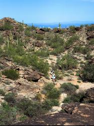
National trail can be acended or decended. Both require expert skills and fitness. You cannot and will not find a climb this technical, challenging and fun in AZ. It will kick your ass and youll love every turn of the peddle. You can ride this trail 365 but, beware of mid afternoon temps in the summer, "theres birds that will pick your bones clean." Courtesy of Singletracks.com
More Information
Add ResourceNever modify trail features. Ride trails when they're dry enough that you won't leave ruts. Speak up when you see others on the trail and always yield to hikers, horses, and others coming uphill. Always ride on the established trail.
Read MoreDirections
From Phoenix, Arizona
- Head west on W Washington St toward 1st Ave (0.5 mi)
- Turn left onto S 7th Ave (2.9 mi)
- Turn right onto W Broadway Rd/W Doctor M.L.K. Jr Blvd (4.0 mi)
- Turn left onto S 43rd Ave (3.3 mi)
- Turn right onto W Olney Ave (0.4 mi)
- Turn left onto S 46th DrRestricted usage road(0.2 mi)
- S 46th Dr turns slightly left and becomes W Coplen Farms RdRestricted usage roadDestination will be on the right(0.1 mi)

Other Mountain Bike Trails Nearby

National Trail
Phoenix, Arizona
1.7 miles SENational Trail is the gem of South Mountain and home to the infamous Waterfall. It’s a local favorite as well as a destination trail for MTB snowbirds. Like most trails in the Sonoran...
Hike, Mountain Bike 0.8-1.0 mi
Kiwanis Trail to Telegraph Pass Lookout
Phoenix, Arizona
4.7 miles EAn ideal hike to take children on as the distance is short and the elevation gain is not extreme. Avid hikers have opportunities to embark on longer hikes into South Mountain. ... This short hike is...
Hike, Mountain Bike
Holbert-Hidden Valley-Mormon Trail Shuttle
Phoenix, Arizona
5.0 miles EHolbert- Hidden Valley- Mormon Trail is a combination trail hike on the north side of South Mountain near Phoenix, Arizona. This trail is approximately 6.5 miles long, and is suitable for...
Hike, Mountain Bike 2.5 mi
Hidden Valley from Buena Vista Trail
Phoenix, Arizona
6.5 miles EFor an easily accessible trail, butting right up against Phoenix’s southern border, it is truly surprising how special, quiet and natural the hike through Hidden Valley is! The path...
Hike, Mountain Bike 2.3 mi
Hidden Valley Trail Via Mormon Trail
Phoenix, Arizona
7.3 miles EHidden Valley Trail via Mormon Trail is a 2-4 mile hike, depending on the route you choose to take and how much additional exploring you do. This hike offers a natural rock tunnel, petroglyphs,...
Hike, Mountain Bike 8.3 mi
Estrella Mountains Competitive Track
Tolleson, Arizona
9.1 miles WThe third competitive track in the Maricopa County Regional Park system, located in Estrella Mountain Regional Park, was completed in February 2000. The track consists of two loops totaling 13 miles....
Hike, Horseback, Mountain Bike
South Mountain Trails (Desert Classic Trail)
Phoenix, Arizona
9.9 miles EHike and Mountain Bike near Phoenix, Arizona
Hike, Mountain Bike 1.5 mi
Desert Classic
Phoenix, Arizona
9.9 miles EThe Desert Classic trail is just that, a classic at the South Mountain Park area. Because it is such a classic, the trail is well marked and well worn by high traffic flow of riders and hikers....
Hike, Mountain Bike
South Mountain National Trail
Phoenix, Arizona
9.9 miles EThe National Trail crosses South Mountain Park from the east to the west ends and intersects with most of the other trails in the park. A very scenic hike with moderate ups and downs...
Hike, Mountain Bike
Desert Classic - Goat Trail
Phoenix, Arizona
9.9 miles EHike and Mountain Bike near Phoenix, Arizona
Hike, Mountain Bike 1.8 mi
Javelina-Beverly Canyon Loop Trail
Phoenix, Arizona
10.0 miles EJavelina Canyon Trail does have some beautiful hills and valleys to wander through and it feels down right remote at times. I’ve found Javelina to have less traffic that Beverly as...
Hike, Horseback, Mountain Bike 1.9 mi
Javelina Trail
Phoenix, Arizona
10.0 miles EComing down Javelina is fast and fun no doubt. It sure beats the crowded Pima Canyon trail back to the Pima lot if you parked there. Javelina is just one more sweet trail on South Mountain. Not a...
Hike, Horseback, Mountain Bike 2.9 mi
Coldwater Trail
Goodyear, Arizona
12.3 miles WThe Cold Water Trail #27 is a seldom visited, remote backcountry destination along the backdrop of the rugged Verde Rim with healthy mixed vegetation and unique geology. The trail was originally used...
Hike, Horseback, Mountain Bike 13.8 mi
Butterfield to Gadsen Loop Trail
Goodyear, Arizona
12.3 miles WAs with other trails in Estrella, the trail is wide and the surface tends to be rather benign, varying from mostly smooth, to occasionally strewn with small rocks, sandy in the washes. Butterfield...
Hike, Horseback, Mountain Bike 3.6 mi
Toothaker Trail
Goodyear, Arizona
12.5 miles WToothaker is an easy roller coaster of a trail. It crosses numerous washes ranging from small to large and can be a tad loose and/or rocky in some sections. The end reward is a nice view of Rainbow...
Hike, Horseback, Mountain Bike
Estrella Mountain Park
Goodyear, Arizona
12.5 miles WNice mix of singletrack and doubletrack. One way loops, long loop and tech loop. A few mild climbs and some mild rock gardens, just let it ride. There is a lot of loose rocks on the...
Mountain Bike
Dysart Trail
Goodyear, Arizona
12.5 miles W$6 entry fee per car.
Hike, Horseback, Mountain Bike
Rainbow Valley to Toothaker Loop Trail
Goodyear, Arizona
12.5 miles WEstrella Mountain Regional Park has many trails within it, a great beginner to intermediate friendly trail is the Rainbow Valley to Toothaker Loop Trail. This 6.6 mile hike is mostly flat with a few...
Hike, Horseback, Mountain Bike 1.0 mi
Quail Trail
Goodyear, Arizona
13.1 miles WQuail Trail is the access trail from the Nature Center to the main trail system. It is a pretty steep climb, but smooth and steady. Quail Trail is a spur trail in the Estrella Mountain...
Hike, Horseback, Mountain Bike 2.0 mi
Loma and Canal Trails
Tempe, Arizona
13.6 miles NETrails open to mountain biking and hiking that wind through the Papago Park in Tempe, Arizona. The Loma Trail winds around lots of uphill and downhill paths, and leads to a park with a small lake and...
Hike, Mountain BikeNearby Campsites

Lower Salt River Nature Trail
Fort McDowell, Arizona
31.5 miles NEThe Lower Salt River Nature Trail is a scenic walk to take at the Tonto National Forest. This trail provides stunning views as you walk alongside the Salt River. This rustic trail is older and less...
Camp, Hike
Buckhorn Campground Nature Trail
Apache Junction, Arizona
32.1 miles ECamp and Hike near Apache Junction, Arizona
Camp, Hike


