Skillern Hot Springs
Fairfield, Idaho
| Address: | Big Smokey Hot Spring |
| GPS: |
43°38'53.0"N 114°48'55.0"W Maps | Directions |
| State: | Idaho |
| Trail Length: | 6.00 miles |
| Trail Type: | Point A to B |
| Hike Difficulty: | Intermediate |
| Trails/Routes: | 3.4 mi |
Restrooms Wildflowers Ponds Fall Colors National Park
Camp, Hike, and Hot Springs
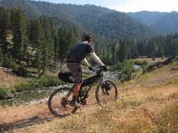
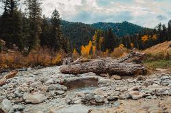
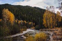
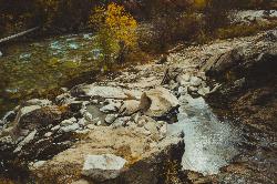
Skillern hot spring is located in Fairfield, Idaho. It is a stunning six mile hike. The trail to Skillern hot spring follows the beautiful Big Smoky Creek, which gives life to the forest. Big Smoky Creek has crystal clear waters that expose smooth stones that have been eroded over time. The river is home to various species of fish, that weave themselves through the boulders in the creek. If you continue to follow the creek, you may find spots that have sitting water, waterfalls, or slow running water. Either way, the creek is a refreshing sight to see.
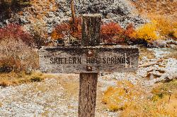
Many have stated that the best time to hike the trail, or go to the hot spring is during the fall. Not only do the colors of the forest change to riveting red, pumpkin tone orange, and zesty yellow, the cool breeze helps to cool down hikers on the way to the hot springs. The trail is known to split into two separate trails that lead to the same thing. One trail is more intense and uphill, while the other is low and continues to follow the creek closely. Both trails have seen hikers, and both trails lead to the hot springs if you are looking for them. The trail however does not end at the hot spring, but can guide you there. On the trail, there is a sign that says "Skillern Hot Spring", from this sign, the hot spring is three miles away.
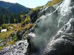
The hot spring itself has the capacity to reach 140 degrees Fahrenheit when you continue up the trail to other portions of the hot spring. However if you want to soak, the hot springs closest to the trail only get up to 90-100 degrees. Skillern hot springs are filled with mineral water often said to relax the body as well as exfoliate dead skin. There are camping grounds located up or down the trail for those who are looking to camp. The hot spring does not look like a typical hot spring, so remember to look for a boulder that appears to be dripping hot water. When approaching the boulder, be careful while navigating to the hot springs. Just on the other side there are other rocks that are slippery and could cause quite a fall. When you see steam coming from multiple boulders, the steam will be your guide to an oval shaped hot spring waiting to welcome you for hours of relaxation.
While the hike requires a little bit of perseverance, it is worth it! You will leave feeling relaxed, lighter, and better than you did before you started the hike.
More Information
Be courteous, informed, and prepared. Read trailhead guidelines, stay on the trail, and don't feed the wildlife.Read More
Be careful. Pay attention to posted signs and always test the waters before you get in. Some hot springs can get up to boiling temperatures. Be sure to drink plenty of water to combat the dehydrating effect of the spring.
Be respectful of other soakers and the hot spring. Don't hog the pool. Camp at least 200 yards away and keep fires in designated areas. Keep your pets out of the water and never pee in thermal feature. Glass bottles should never go near a hot spring.Read More
Directions
From Fairfield, Idaho
- Head west on Camas Ave E toward Soldier Rd (66 ft)
- Turn right at the 1st cross street onto Soldier Rd (1.6 mi)
- Turn right onto 200 N/
Base Line Rd (0.3 mi) - Turn left onto NF-094/
Soldier Creek Rd (4.1 mi) - Turn left to stay on NF-094/
Soldier Creek Rd Continue to follow Soldier Creek Rd(3.2 mi) - Continue straight (0.1 mi)
- Continue onto Nfdr 94 Rd/
Soldier Creek Rd (0.2 mi) - Slight right onto NF-94 (394 ft)
- Slight right to stay on NF-94 (4.3 mi)
- Turn right to stay on NF-94 (0.1 mi)
- Continue onto NF-Road094 (4.3 mi)
- Slight left onto Forest Rd 227 (5.6 mi)
- Turn right onto Boise River Rd/
NF-12 Continue to follow Boise River Rd(8.5 mi) - Turn right onto Forest Rd 030 (5.8 mi)
- Turn left onto Forest Rd 056 (2.7 mi)
Directions to the hotspring from the Five Points camping grounds:
- Head south on Big Smoky Rd toward Forest Rd 087
- Turn left onto Boise River Rd/NF-12
- Turn left onto Forest Rd 227
- Slight right onto NF-Road094
- Turn right
- Turn left
*Destination will be on your left*
Trails
Distance ?
3.4 milesElevation Gain ?
437 feetReal Ascent ?
899 feetReal Descent ?
462 feetAvg Grade (1°)
2%Grade (-24° to 33°)
-44% to 65%Elevation differences are scaled for emphasis. While the numbers are accurate, the cut-away shown here is not to scale.
Other Hiking Trails and Hot Springs Nearby

Little City of Rocks
Gooding, Idaho
37.1 miles SNot to be confused with the City of Rocks National Reserve, Little City of Rocks is located near Gooding, Idaho. There are two portions to the area, the Little City of Rocks and the Gooding City...
Camp, Hike
Loftus Hot Spring
Mountain Home, Idaho
39.8 miles WCamp and Hot Springs near Mountain Home, Idaho
Camp, Hot Springs
Sunbeam Hot Springs
Stanley, Idaho
43.0 miles NRiverside, rock walled, user-built pools that vary in size and temperatures with rock, gravel and sand bottoms. Located just off HWY 75 near Sunbeam. Pools are below the historic Sunbeam...
Hot Springs
Bonneville Hot Springs
Lowman, Idaho
43.0 miles NWBonneville Hot Springs are a series of soaking pools that are the most popular activity for visitors to Bonneville Campground outside of Lowman Idaho. The campground is located besides Warm Springs...
Camp, Hike, Hot Springs
Kirkham Hot Springs Campground
Lowman, Idaho
46.5 miles NWKirkham Hot Springs, located near the official Boise National Forest campground of the same name, features somewhat shallow rock pools (unimproved) with sand/rock bottoms next to the river. The...
Camp, Hot SpringsNearby Campsites

Galena Lodge
Ketchum, Idaho
17.4 miles NEGalena Lodge is a community owned seasonal day lodge nestled in the Rocky Mountains, 23 miles north of the Sun Valley Resort and Ketchum, Idaho. The historic Galena Lodge is open in both summer and...
Camp, Cross-country Ski, Snowshoe
Little City of Rocks
Gooding, Idaho
37.1 miles SNot to be confused with the City of Rocks National Reserve, Little City of Rocks is located near Gooding, Idaho. There are two portions to the area, the Little City of Rocks and the Gooding City...
Camp, Hike
Loftus Hot Spring
Mountain Home, Idaho
39.8 miles WCamp and Hot Springs near Mountain Home, Idaho
Camp, Hot Springs
Bonneville Hot Springs
Lowman, Idaho
43.0 miles NWBonneville Hot Springs are a series of soaking pools that are the most popular activity for visitors to Bonneville Campground outside of Lowman Idaho. The campground is located besides Warm Springs...
Camp, Hike, Hot Springs
McKinney Butte Lava Tubes
Gooding, Idaho
43.6 miles SAlso known to the locals as the Spider Caves, the McKinney Butte Lava Tubes is a tunnel formed by lava flows from long ago. Similar to many lava tubes with an entrance broken from the side of...
Camp, Cave
Badger Creek Campground
Boise City-Nampa, ID, Idaho
44.8 miles W3200-foot elevation. 5 campsites on the Middle Fork of the Boise River. Fishing for rainbow and cutthroat trout, and whitefish. The William Pogue National Recreational Trail is a few miles north of...
Camp
Kirkham Hot Springs Campground
Lowman, Idaho
46.5 miles NWKirkham Hot Springs, located near the official Boise National Forest campground of the same name, features somewhat shallow rock pools (unimproved) with sand/rock bottoms next to the river. The...
Camp, Hot Springs
Park Creek Campground
Lowman, Idaho
50.0 miles NWThis smaller sized campground is situated in a lovely old-growth forested setting along Park Creek in the Baker Lake basin. This tranquil setting is in close proximity to the shores of Baker Lake...
Camp


