Sharkey Hot Springs
Salmon, Idaho
| Address: | NF-185, Salmon, ID 83467, USA |
| GPS: |
45°0'38.1"N 113°36'43.5"W Maps | Directions |
| State: | Idaho |
Restrooms
Hot Springs
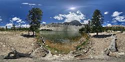
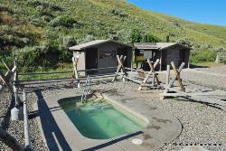
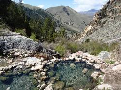
This site is a popular destination for soaking, biking, picnicking and scenic viewing. It includes two soaking pools, restrooms, changing rooms, picnic tables, a large group fire ring and a parking area. The site is named for B.F. Sharkey, an early settler of Lemhi County. The springs were originally developed around 1890 and attracted people from the Lemhi Valley and Salmon River area.
Rates on BLM.gov
More Information
Be careful. Pay attention to posted signs and always test the waters before you get in. Some hot springs can get up to boiling temperatures. Be sure to drink plenty of water to combat the dehydrating effect of the spring.
Be respectful of other soakers and the hot spring. Don't hog the pool. Camp at least 200 yards away and keep fires in designated areas. Keep your pets out of the water and never pee in thermal feature. Glass bottles should never go near a hot spring.
Directions
From Salmon, Idaho
- Head northeast on S St Charles St toward Main St (203 ft)
- Turn right at the 1st cross street onto Main St (0.5 mi)
- Continue straight onto ID-28 S/Main StContinue to follow ID-28 S(16.7 mi)
- Turn left (0.4 mi)
- Turn right onto Back Rd (0.7 mi)
- Turn left onto Warm Springs Rd (1.1 mi)
- Turn left onto NF-185/Warm Springs Rd (0.8 mi)
- Continue straight to stay on NF-185/Warm Springs Rd (318 ft)
19 miles southeast of Salmon, Idaho. Traveling southeast of Salmon on Highway 28 to Tendoy, then turn north and follow the signs for Warm Springs Road and Sharkey Hot Springs. The Hot Springs are located about 5 miles from Tendoy, Idaho.
Other Hot Springs Nearby
Nearby Campsites

Salmon River
Salmon, Idaho
33.9 miles NWThe Salmon River originates in the Sawtooth and Lemhi Valleys of central and eastern Idaho. Springs and snowmelt from the Sawtooth and Salmon River mountains feed this wild river. The river flows...
Camp, Whitewater
Minneopa Lake
Polaris, Montana
41.1 miles NEThis is a beautiful short hike that is easily the start of a great trip between several lakes or just a nice easy kid hike. Length: .25 mile (.5 mile roundtrip)
Backpack, Camp, Hike
North Fork Canyon (River of No Return)
McCall, Idaho
41.3 miles NWKnown as "The River of No Return," the Salmon River is the longest free-flowing river (425 miles) within one state in the lower 48. It originates in the Sawtooth and Lemhi Valleys of central and...
Camp, Canoe, Cave, Hike, Horseback, Mountain Bike, Whitewater 1.1-4.1 mi
Meadow Lake
Leadore, Idaho
42.5 miles SMeadow Lake is a small alpine lake in Boise County, Idaho, United States, located in the Sawtooth Mountains in the Sawtooth National Recreation Area. There are no trails leading to the lake or the...
Camp, Canoe, Hike
Barretts Station Park
Dillon, Montana
43.2 miles EThis is a great FREE campground right off the highway. There's tent and trailer sites, a water pump for drinking water, handicap accessible bathrooms. The campground continues across the river...
Camp, Rock Climb, Swim


