Riverfront Park
Cottonwood, Arizona
| Address: | 10th St., Cottonwood, AZ |
| GPS: |
34°45'6.1"N 112°1'19.6"W Maps | Directions |
| State: | Arizona |
Disc Golf
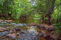
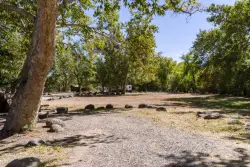
Winds through rich riparian area with large, mature cottonwoods. Several very narrow fairways through the trees. Deep, soft weeds, so keep a good eye on your landings. A map is really helpful. Public (No Fee)Courtesy of DiscGolfUnited.com
More Information
Add ResourceDirections
From Cottonwood, Arizona
- Head north on S Main St toward E Mingus Ave (0.6 mi)
- Turn right onto N 10th St (0.6 mi)
- Continue onto 10th St (0.2 mi)
I-17; exit 287. Go north on AZ-260 W/Camp Verde-Bridgeport Hwy for 11.8 miles to a left on Main St., 2 miles to a right on N. 10th St. Go 0.2 miles to the park. Go toward the fields on the right. Park by skate park. 1st tee is next to the roller hockey court.Courtesy of DiscGolfUnited.com

Other Folf Courses Nearby

School House Gulch
Prescott, Arizona
30.3 miles SWSituated in pines and oaks at 6000'. Targets are marked trees. Features a mix of tight lines, long drives, and plenty of elevation. Map at web site 80% accurate (shows course prior to 2006...
Disc Golf
Northern Arizona University Disc Golf Course
Flagstaff, Arizona
36.2 miles NEDense Ponderosa pine forest at 7,000 feet in elevation. Features tight paths, nice elevation and tough lies. A few good long holes make for a complete package. Maintained very nicely. Woodchip trails...
Disc Golf
Ridge Line Disc Golf Course
Flagstaff, Arizona
36.6 miles NEWinds through apartments complex. Short and technical with significant elevation and great views of the San Francisco peaks. 1st tee is near apartment office. Water and OB in play. Private (No Fee)
Disc Golf
Thorpe Park
Flagstaff, Arizona
37.5 miles NEAt 7000' elevation, winding through Ponderosa forest with some open shots and more tight ones. City advice; play at your own risk - rocky terrain. Designer; Gary Bennett. Map at 2nd website....
Disc Golf
McPherson Park
Flagstaff, Arizona
38.6 miles NEModerate terrain, rocky in places. Ponderosa pine and oak. Good elevation with views of the San Francisco Peaks. Tough to navigate - map at Activity Center or website. Closed for winter, Nov. to...
Disc Golf
Arizona Snowbowl
Flagstaff, Arizona
43.7 miles NEPremier course nestled below the summit of the majestic Humphreys Peak. Starts and finishes at the Agassiz Lodge (9500'), with a practice basket just outside the Lodge. Map at website. Public...
Disc GolfNearby Campsites

Chavez Crossing
Sedona, Arizona
15.3 miles NEChavez Crossing is a campground in Sedona, Arizona. It sits perfectly nestled in Arizona's most beautiful red rock attractions along with the grand summer sunsets. If that didn't sound...
Camp, Hike, Swim
Beaver Creek Dispersed Camping
17.5 miles E
Free dispersed camping on the cliffs above Beaver Creek.
Camp
Beaver Creek Campground
Camp Verde, Arizona
18.4 miles ECamp, Canoe, Kayak, and Swim near Camp Verde, Arizona
Camp, Canoe, Kayak, Swim 0.4 mi
Clear Creek Campground
Camp Verde, Arizona
21.8 miles SEWest Clear Creek flows along the boundary of this desert canyon country camp and is a popular place for hiking, swimming, wading and fishing. Cool water species such as smallmouth bass and green...
Camp, Hike, Swim 0.1-0.7 mi
Cave Springs
Sedona, Arizona
23.3 miles NECave Springs Campground is a scenic campground that sits in Oak Creek Canyon. Cave Springs is nestled perfectly in the town of Sedona, giving the campground the notorious Sedona red views. Uniquely,...
Camp, Hike, Swim 0.1-7.8 mi
Wolf Creek Falls
Sedona, Arizona
32.6 miles SWWolf Creek Falls is a wonderful space to explore and be immersed in nature. With it's six miles of trails, beautiful waterfalls and two campgrounds this is the perfect place to spend a...
Camp, Hike, Swim
Verde Hot Springs
Camp Verde, Arizona
33.5 miles SEVerde Hot Springs are a few natural hot spring pools located along the Verde River, near Sedona, Arizona. Once a resort, now all that remains are the foundations and the hot pools...
Camp, Hike, Hot Springs


