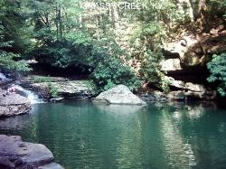
Red River George (Jumping Rock)
Gilbertsville, Kentucky
| GPS: |
37°49'32.9"N 83°37'41.5"W Maps | Directions |
| State: | Kentucky |
| Trails/Routes: | 0.1 mi |
Restrooms Picnic Tables
Hike and Swim
Jumping Rock at Red River George is the perfect hidden swimming hole. The swimming hole can be found a short hike from the Red River George Parking Lot. At this point the river calms beside a small sandy beach, and a large rock from whence Jumping Rock got it's name. The water here is deep enough for jumping and diving off the rocks. This picturesque swimming spot is the perfect place to cool off on a hot humid day.
To get to Jumping Rock you will take Sheltowee Connector/Suspension Bridge Trail. This wooded trail is beautiful and continues past the swimming hole for people wanting to continue this scenic hike. The suspension bridge hovers over Red River and is a unique addition to this natural swimming hole.
More Information
Be courteous, informed, and prepared. Read trailhead guidelines, stay on the trail, and don't feed the wildlife.Read More
Directions
From Gilbertsville, Kentucky
- Head northeast on Owens St toward W 1st St (0.1 mi)
- Turn right onto KY-282 (2.4 mi)
- Take the ramp to Princeton/
Marion (0.2 mi) - Merge onto US-62 E/
US-641 N (2.6 mi) - Exit on the left onto KY-453 N toward Smithland (1.3 mi)
- Take the ramp onto I-24 E/
I-69 N (10.4 mi) - Take exit 42 toward Princeton/
Elizabethtown (0.8 mi) - Continue onto I-69 N (37.5 mi)
- Keep right at the fork to continue on Western Kentucky Pkwy, follow signs for Elizabethtown (99.1 mi)
- Take exit 137B to merge onto I-65 N toward Lexington/
Louisville (2.3 mi) - Take exit 93 for Blue Grass Pkwy toward Bardstown/
Lexington (0.6 mi) - Continue onto KY-9002 E/
Bluegrass Pkwy/ Rte 9002 E (70.6 mi) - Take exit 72A to merge onto US-60 E/
Lexington Rd toward Lexington Continue to follow US-60 E(6.4 mi) - Take the KY-4 N/
New Circle Rd ramp to I-75/ I-64 (0.5 mi) - Merge onto KY-4 N/
W New Cir Rd (4.3 mi) - Take exit 9B to merge onto KY-922 N/
Newtown Pike toward I-64/ I-75 (1.9 mi) - Merge onto I-64 E/
I-75 S via the ramp to Ashland/ Knoxville (4.0 mi) - Keep left at the fork to continue on I-64 E, follow signs for Winchester/
Ashland (16.1 mi) - Take exit 98 for Bert T Combs Mountain Parkway toward Campton (0.7 mi)
- Continue onto Bert T Combs Mountain Pkwy E (32.2 mi)
- Take exit 33 toward Slade (0.2 mi)
- Turn left onto KY-11 N (0.1 mi)
- Turn left onto KY-11 N/
KY-15 N (1.5 mi) - Turn right onto KY-77 N (5.1 mi)
- Turn right onto KY-715 SDestination will be on the left(1.5 mi)

Trails
Distance ?
772 feetElevation Gain ?
-8 feetReal Ascent ?
11 feetReal Descent ?
19 feetAvg Grade (-1°)
-1%Grade (-7° to 3°)
-12% to 5%Elevation differences are scaled for emphasis. While the numbers are accurate, the cut-away shown here is not to scale.
Other Swimming Holes and Hiking Trails Nearby

Grassy Creek
Mize, Kentucky
15.7 miles EGrassy Creek is a beautiful bright blue swimming hole in Breaks Interstate Park. With rock formations and a waterfall surrounding this swimming hole it makes for a picturesque way to cool off on a...
Swim
Pickle Fork
Oil Springs, Kentucky
39.9 miles EPickle Fork is a deep section on Cane Branch off of Pennsylvania Lake. This popular swimming hole is known for the beautiful blue-green water and the surrounding cliffs. The cliffs come in several...
Swim


