


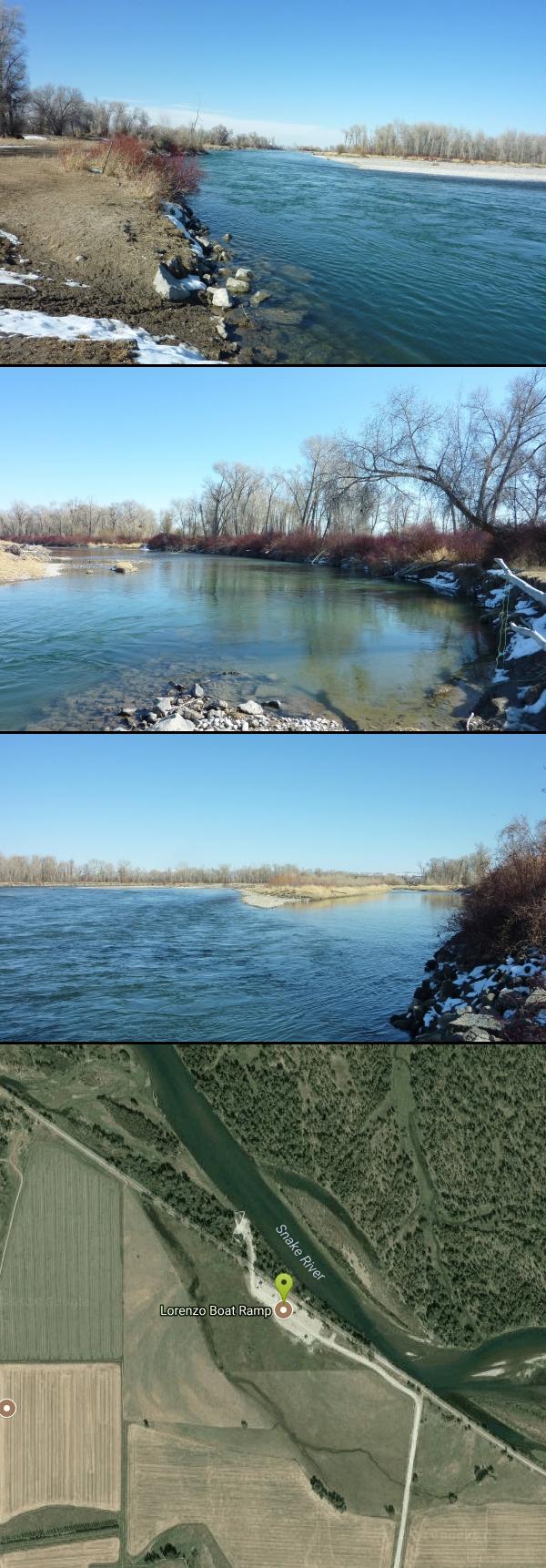
Lorenzo Boat Ramp
Rigby, Idaho

| Address: | 4127 E Menan Lorenzo Hwy, Rigby, ID 83442, USA |
| GPS: |
43°44'10.3"N 111°52'49.2"W Maps | Directions |
| State: | Idaho |
Hike and Kayak
More Information
Add ResourceBe courteous, informed, and prepared. Read trailhead guidelines, stay on the trail, and don't feed the wildlife.
Read More- Plan Ahead and Prepare
- Travel & camp on durable surfaces
- Dispose of waste properly
- Leave what you find
- Minimize campfire impacts
- Respect wildlife
- Be considerate of other visitors
Directions
From Rigby, Idaho
- Head south on N State St toward W Main St (75 ft)
- Turn left at the 1st cross street onto E Main St (0.2 mi)
- Continue onto US-20 BUS E/Farnsworth Way (0.9 mi)
- Turn left to merge onto US-20 E toward Rexburg/W.Yellowstone (2.9 mi)
- Take exit 325 toward Menan/Roberts (0.4 mi)
- Turn left (0.4 mi)
- Turn right onto E 700 NDestination will be on the left(1.3 mi)
 courtesy of Ray Hannah↗")
 courtesy of Ray Hannah↗")
Other Hiking Trails and Kayaking Areas Nearby

Lorenzo Bridge
Rexburg, Idaho
0.7 miles EThis is the old site of the Lorenzo Boat Launch, which has moved to the other side of the river a little further downstream. This spot sees very little traffic. There are beautiful, yet...
Airsoft, Hike, Paintball
Jefferson County Lake (AKA Rigby Lake)
Rigby, Idaho
2.8 miles SWRigby Lake has long been a favorite swimming hole for those in the area. The county has taken it well under its wing and made it a buzzing spot on any warm summer day. Along with the long standing...
Camp, Canoe, Dive, Kayak, Sled, Swim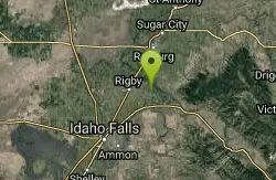
Rigby Wave-45th Wave
Rigby, Idaho
5.8 miles SEKayak near Rigby, Idaho
Kayak 0.6-2.0 mi
North Menan Butte ('R' Mountain)
Menan, Idaho
6.5 miles NWThe North Menan Butte is more commonly known to the locals and college students as R Mountain. Many kids know it better as Ou'R' Mountain. The butte is a rare and unique geological area and provides...
Camp, Cave, Hike 0.1-0.5 mi
Eagle Park
Rexburg, Idaho
8.0 miles NEEagle Park is a little urban oasis. Once you drive in to this cottonwood forest along the river, you may forget that you're still inside Rexburg city limits. You can camp, picnic, throw rocks in...
Camp, Hike, Mountain Bike, Sled 0.1-2.3 mi
Hidden Valley Trails
Rexburg, Idaho
8.3 miles NERight on the edges of town outside of the Hidden Valley subdivision, you'll find this fun little set of trails that's pretty good for mountain bikes. It is mostly a dirt bike...
Hike, Mountain Bike 0.3-0.6 mi
Cress Creek Nature Trail
Rexburg, Idaho
9.7 miles SEMeandering along the scenic South Fork of the Snake River, the beautiful 1¼ mile Cress Creek Nature Trail will lead you on a journey through sagebrush-grass communities, over juniper covered...
Hike
Herbert Idaho Ghost Town
Ririe, Idaho
11.2 miles ECLOSED. Private property marked NO TRESPASSING. Herbert is a small ghost town that was operated until the 40s, but with the invention of the automobile, it was much more convenient to live in Rexburg...
Hike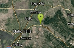
Big Feeder
Ririe, Idaho
11.8 miles SEKayak near Ririe, Idaho
Kayak 2.1-2.3 mi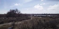
Market Lake Wildlife Management Area
Roberts, Idaho
13.3 miles WMallards, Canada geese, canvasbacks, cinnamon and green-winged teal, northern shovelers and ruddy ducks are common waterfowl species nesting and raising broods on the WMA. Several thousand...
Hike, Horseback 0.5-3.5 mi
Webster's Dam
Ririe, Idaho
14.3 miles EAlso known as Manmade Falls or the Woodmansee Dam, Webster Dam is an abandoned dam located deep in Moody Creek canyon, the dam was abandoned when sediment built up behind the dam which then...
Camp, Hike, Mountain Bike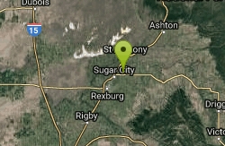
Sucky Courtney's
Saint Anthony, Idaho
14.4 miles NEKayaker playing in Marshall's Wave near Rexburg, Idaho. The wave is located on the North Fork of the Teton River and is best at flows above 600 cfs. The wave is good for beginners. It has a...
Kayak 3.8 mi
Stinking Springs
Ririe, Idaho
14.6 miles SEStinking Springs is a great early to late season trail. Being at the edge of the Big Hole range, it gets spring earlier and winter later than other trails in the range. It's closed from December...
Hike, Mountain Bike 3.8 mi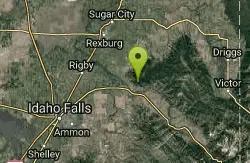
Kelly Mountain Trail
Ririe, Idaho
15.1 miles SEKelly Canyon Trail is a moderate, uphill trail that can be used by hikers, mountain bikers, and ATV riders. The trail features views of hills, mountains, trees, wildflowers, and some wildlife. Dogs...
Cross-country Ski, Hike, Mountain Bike, Snowshoe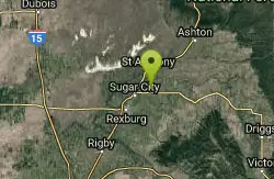
Marshall's
Saint Anthony, Idaho
15.4 miles NEMarshall's Wave is located on the North Fork of the Teton River, where the Teton River splits into the north and south forks. The wave is created by a headgate and is best at flows above 600...
Kayak 1.7 mi
Buckskin Morgan Ridge
Ririe, Idaho
15.6 miles SECLOSED. This land is owned and managed by the US Forest Service and is not designated for use. As of July 2024, being caught mountain biking on this trail could recieve up to a $5000 fine and a...
Hike, Mountain Bike 1.1 mi
Hidden Vista / Pine Loop
Ririe, Idaho
15.6 miles SECLOSED. This land is owned and managed by the US Forest Service and is not designated for use. As of July 2024, being caught mountain biking on this trail could recieve up to a $5000 fine and a...
Hike, Mountain Bike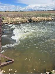
The Junk Field Wave
Idaho Falls, Idaho
15.8 miles SWKayak near Idaho Falls, Idaho
Kayak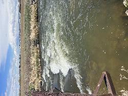
Double Tap wave feature
Idaho Falls, Idaho
15.8 miles SWIt's a fun little double feature in an irrigation canal the first is a open elevation control dam that throws a nice wave and foam pile off of it great for freestyle kayaking then about 30 yards...
Canoe, Kayak
Poison Flats
Ririe, Idaho
15.9 miles SEHike near Ririe, Idaho
HikeNearby Campsites
Jefferson County Lake (AKA Rigby Lake)
Rigby, Idaho
2.8 miles SWRigby Lake has long been a favorite swimming hole for those in the area. The county has taken it well under its wing and made it a buzzing spot on any warm summer day. Along with the long standing...
Camp, Canoe, Dive, Kayak, Sled, Swim
Beaver Dick Park
Rexburg, Idaho
6.3 miles NBeaver Dick is a park 4.5 miles west of Rexburg, Idaho on Hwy 33. It's a 9.5 acre park that passes next to the west bank of the Henry Fork of the Snake River; it's a popular...
Camp, Canoe, Disc Golf, Swim 0.6-2.0 mi
North Menan Butte ('R' Mountain)
Menan, Idaho
6.5 miles NWThe North Menan Butte is more commonly known to the locals and college students as R Mountain. Many kids know it better as Ou'R' Mountain. The butte is a rare and unique geological area and provides...
Camp, Cave, Hike
Twin Bridges Park
Rexburg, Idaho
7.2 miles SETwin Bridges is a campground 12 miles South East of Rexburg on S. 600 E. It is maintained by Madison County Parks Department. It is a 27 acre park of pristine land rich with wildlife on the Snake...
Camp, Canoe 0.1-0.5 mi
Eagle Park
Rexburg, Idaho
8.0 miles NEEagle Park is a little urban oasis. Once you drive in to this cottonwood forest along the river, you may forget that you're still inside Rexburg city limits. You can camp, picnic, throw rocks in...
Camp, Hike, Mountain Bike, Sled 0.8-1.3 mi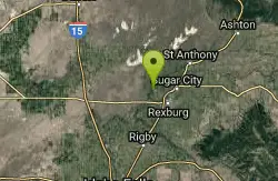
Warm Slough Campground
Rexburg, Idaho
9.3 miles NThis is a pretty popular campsite that fills up pretty quick on busy weekends. Campsites are fairly spread out and there is no official donation box (as of July 2015). A couple of the campsites...
Airsoft, Camp, Canoe
Paramount Wall / Blanche Rock
Ririe, Idaho
13.2 miles SESitting high above the road, the routes at Paramount offer great exposure and relief from the afternoon summer sun. Chuck Oddette, Steve Reiser and Jed Miller established the routes from 1989...
Camp, Horseback, Rock Climb
Kelly Island Campground
Ririe, Idaho
13.4 miles SEThis is a BLM campground with 14 campsites for RVs or tents and 1 group campsite. Daily Rates $5-20 Showers No Bathrooms Vault...
Camp 0.5-3.5 mi
Webster's Dam
Ririe, Idaho
14.3 miles EAlso known as Manmade Falls or the Woodmansee Dam, Webster Dam is an abandoned dam located deep in Moody Creek canyon, the dam was abandoned when sediment built up behind the dam which then...
Camp, Hike, Mountain Bike
Big Hole Dispersed Campsites
Ririe, Idaho
14.4 miles EA dispersed campsite is simply an unestablished and unmaintained area where people camp. Often, this means that there is a campfire or other basic campsite feature to identify the site and that's...
Camp
Table Rock Campground
Ririe, Idaho
16.3 miles SETable Rock / Poison Flat Campground is located at the Caribou-Targhee National Forest which occupies over 3 million acres and stretches across southeastern Idaho, from the Montana, Utah, and Wyoming...
Camp
Wolf Flats Recreation Area
Ririe, Idaho
16.5 miles SEWolf Flats is a completely free, dispersed, undeveloped camping area with 25 locations to camp. Some areas are large enough to accommodate groups of 50 people.
Camp
Moody Meadows
Driggs, Idaho
21.1 miles EGood place for kids, they can ride bikes in the meadow, play in the stream, and camping is off of the road. Hiking, motorbiking, and horseback riding trails are abundant in the area.
Camp
Sealander Park
Idaho Falls, Idaho
25.1 miles SWThe story of Sealander park begins with Carl Sealander. Leaving Sweden in 1893 at the age of seventeen, Carl worked in mining communities across Colorado and Utah before meeting his wife, Lizzie...
Camp
Fall Creek Falls
Swan Valley, Idaho
32.5 miles SEFalls Campground is located next to the Snake River near beautiful Swan Valley, only 45 miles east of Idaho Falls, Idaho. Mixed growth cottonwood trees provide partial shade, and grassy meadows with...
Camp, Cave, Hike, Kayak, Swim
Falls Campground
Victor, Idaho
33.4 miles SEFalls Campground is located next to the Snake River near beautiful Swan Valley, only 45 miles east of Idaho Falls, Idaho. Mixed growth cottonwood trees provide partial shade, and grassy meadows...
Camp
Firth River Bottoms
Firth, Idaho
33.6 miles SWWhether you like to ride horses, picnic, camp, fish, learn about the past, or play baseball, this park has something for everyone. The Parks & Recreation Department and the IDaho Education...
Camp, Canoe, Hike
Pine Creek Campground
Victor, Idaho
35.6 miles EThe Pine Creek Campground has 10 single units and has restrooms.
Camp
Pine Butte / The Caldera
St. Anthony, Idaho
36.6 miles NThis is about as close to an oasis as you can get in the deserts of Idaho. It's an old volcano in the middle of the sagebrush desert. As soon as you start down the path, you can feel the air...
Camp, Hike, Horseback
Badger Creek
Tetonia, Idaho
37.4 miles EBadger Creek is a stream located just 13.6 miles from Ashton, in Teton County, in the state of Idaho, United States, near France, ID. Whether you’re spinning, baitcasting or fly fishing your...
Camp, Cross-country Ski, Hike, Mountain Bike, Rock Climb


