McGalliard Falls Park
Valdese, North Carolina
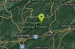
| Address: | 1100-1162 Falls Rd, Valdese, NC 28690, USA |
| GPS: |
35°45'53.5"N 81°34'10.1"W Maps | Directions |
| State: | North Carolina |
Fishing
Hike
Swimming places near Morgantown. For details...Courtesy of swimmingholes.org
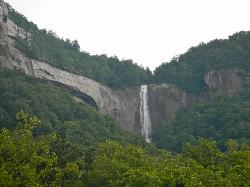
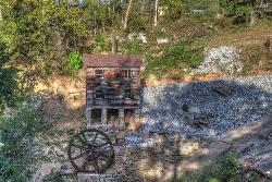
Families would gather on Sunday afternoons to enjoy each other’s company and play an exciting game of bocci. Today, McGalliard Falls is still a favorite location for visitors and features a grist mill, waterwheel, nature trails, picnic and play areas and the beautiful 45-foot waterfall.Courtesy of visitnc.com
More Information
Be courteous, informed, and prepared. Read trailhead guidelines, stay on the trail, and don't feed the wildlife.
Read More- Plan Ahead and Prepare
- Travel & camp on durable surfaces
- Dispose of waste properly
- Leave what you find
- Minimize campfire impacts
- Respect wildlife
- Be considerate of other visitors
Directions
From Valdese, North Carolina
- Head west on Massel Ave SE toward Rodoret St S (0.2 mi)
- Turn right onto Praley St SW (0.2 mi)
- Turn left onto Main St W (0.2 mi)
- Turn right onto Church St NW (1.3 mi)
- Continue onto Falls RdDestination will be on the right(0.2 mi)
From I-40, south of Morganton: see below
MCGALLIARD FALLS PARK (MCGA): In Valdese, a park with old grist mill, picnic area, ball field and waterfall with deep pool at the bottom. Swimming here is unofficial, we believe. Check currents before you go in. Be careful if you choose to jump. Snakes and rocks. To get here, from Morganton travel east on I-40, get off at Exit 112 (Valdese) and take Eldred St. north. Continue through Valdese, cross RT 70, then Eldridge St. will turn into Laurel St.. Continue north on Laurel St. and, at about 1.8 miles from RT 70, turn left onto Meytre Avenue. Go straight onto McGalliard Park Ave and find the parking lot for the park. Swimming hole is at the bottom of falls in this park. LAT, LON : lat=35.76598, lon= -81.56816 (source: map ) (accuracy: approximate) LINK TO GOOGLE MAP. Pretty confident. Not verified. Updated 5/2012 Courtesy of swimmingholes.org