Hubbards Cave
Glenwood Springs, Colorado
| GPS: |
39°33'48.8"N 107°13'20.3"W Maps | Directions |
| State: | Colorado |
Cave and Hike
This trail is generally accessible from April to October. It's 9 miles each way. The trail is used by ATVs, mountain bikers, and hikers.
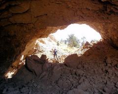
This road takes you to the Hubbard Cave trail. Hike the trail for 1/4 mile to the cave entrance. Hubbard Cave has approximately 3,000 feet of passage with a vertical relief of only 50 feet. It was probably formed by erosion from a stream derived from groundwater in the lower beds of Leadville limestone and Dyer dolomite. Remember cave features are protected by law. Help preserve this natural wonder for future generations to enjoy.
The cave is a rectangular network of three parallel passages, each with its own entrance. There are large quantities of cave coral, but it is mostly restricted to the upper level.
The Grape Room, deep in the cave, has unusual small, rounded botryoid formations. The Gypsum room has a large concentration of gypsum flowers, gypsum blisters, selenite needles and angel's hair.
Courtesy of https://fs.usda.gov
More Information
Be courteous, informed, and prepared. Read trailhead guidelines, stay on the trail, and don't feed the wildlife.
Read MoreDirections
From Glenwood Springs, Colorado
- Head south on Pine St toward 6th St (115 ft)
- Turn right at the 1st cross street onto 6th St (0.1 mi)
- Turn left onto CO-82 W (492 ft)
- Turn left onto the ramp to Denver (0.1 mi)
- Merge onto I-70 E (6.6 mi)
From Carbondale, proceed north on Hwy 82 for about six miles. Turn east on county road #114. Continue on #114 past the Colorado Mountain College Campus, trurn left at the junction with Country Road #115. Continue north on #115 approximately three miles, then turn right on the Lookout Mountain Road #120. Approximately 1.5 miles north on road 120, turn right on the jeep trail. From this point the road becomes 4-wheel drive and is impassible when wet. After turning onto the jeep trail, continue through the first intersection, then follow the left fork of the second intersection to Bear Creek. After crossing the creek, take the right fork of the intersecton and continue uphill. The jeep trail will continue for two more miles and dead-ends at the Hubbard Cave Trailhead.
Courtesy of https://fs.usda.gov
Other Hiking Trails and Caves Nearby

Cave of the Clouds
Glenwood Springs, Colorado
4.3 miles WCLOSED. No Trespassing. The Cave of the Clouds property has new ownership who are members of the National Speleological Society and have bought the property for the sole purpose of protecting what is...
Cave
Premonition Cave
Gypsum, Colorado
9.6 miles NPremonition is located in a buttress on the north rim of Deep Creek Canyon, 1 mile NNW of the Deep Creek Overlook on the south rim. Once inside, there is everything from walking passages, to...
Cave
Spring Cave
Meeker, Colorado
26.5 miles NWLocated in Colorado in the White River National Forest, in the South Fork Valley of the White River, Spring Cave is a large, not completely explored cave that has been largely cut out by an...
Cave
Fulford Cave
Basalt, Colorado
30.5 miles EFulford Cave Campground is located in a sparse stand of young aspen, spruce and fir, near an active beaver pond and East Brush Creek. From this high location, there are nice views of Yeoman Park...
Camp, Cave
Bonnies hall
Meredith, Colorado
32.2 miles EAbout 200 feet of passage. Small cave with some pretties located at Basalt, CO 81621 United States.
Cave
Maroon Bells
Aspen, Colorado
35.5 miles SEOne of the most photographed peaks in Colorado and possibly North America, the Maroon Bells are two fourteeners framing the beautiful Maroon Lake. Very popular to visit in every season, the Maroon...
Backpack, Camp, Hike
Anvil Points Claystone Cave
Rifle, Colorado
37.0 miles WAs the name implies this is a claystone cave. it has around 2,500 feet of passage inside. The passage ranges from crawl ways to large walking passages. When caving always go prepared. 3 sources of...
CaveNearby Campsites

Fulford Cave
Basalt, Colorado
30.5 miles EFulford Cave Campground is located in a sparse stand of young aspen, spruce and fir, near an active beaver pond and East Brush Creek. From this high location, there are nice views of Yeoman Park...
Camp, Cave
Maroon Bells
Aspen, Colorado
35.5 miles SEOne of the most photographed peaks in Colorado and possibly North America, the Maroon Bells are two fourteeners framing the beautiful Maroon Lake. Very popular to visit in every season, the Maroon...
Backpack, Camp, Hike


