


41 Hiking Trails near West Clear Creek Trail No. 17
first prev 1 2 3 next lastShowing Hiking Trails within 50 miles Distance miles of Below Bull Pen, Camp Verde, AZ 86322, USA City, Zip, or Address
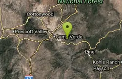
Bullpen Day Use Area
Camp Verde, Arizona
0.0 miles NEBullpen has something for everyone. Whether you park here and use the trail head to start on one of several hikes that lead down West Clear Creek, or stay nearby to use the picnic areas and...
Backpack, Dive, Hike, Swim 3.0 miBlodgett Basin Trail No. 31
Camp Verde, Arizona
0.2 miles EBlodgett Basin Trail is one of a select few trails that shows off the riparian desert beauty unique to West Clear Creek Wilderness. The trail stretches from Bull Pen Trailhead through the canyon and...
Backpack, Hike, Swim 0.4 mi
Clear Creek Campground
Camp Verde, Arizona
3.8 miles SWWest Clear Creek flows along the boundary of this desert canyon country camp and is a popular place for hiking, swimming, wading and fishing. Cool water species such as smallmouth bass and green...
Camp, Hike, Swim 7.1 mi

The Crack at Wet Beaver Creek
Rimrock, Arizona
9.3 miles NThe Crack is a popular swimming hole found by hiking the Bell Trail down to Wet Beaver Creek. After following the trail for about 3.5 miles away from the parking lot, take a detour to the left just...
Dive, Hike, Horseback, Swim 1.1 mi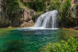
Fossil Creek Waterfall
Pine, Arizona
10.8 miles SEFossil Creek is one of Arizona's two designated "Wild and Scenic" rivers. The waterfall is the most popular place to visit to cool off and see the natural beauty. Located between...
Hike, Swim 0.1-3.8 mi
Fossil Springs Trail No. 18
Pine, Arizona
12.2 miles SELocated within the Fossil Springs Wilderness, this trail leads down a canyon to the springs for which it is named. At the trailhead, there are several hikes, some of which are available for...
Hike, Horseback, Swim 2.2-6.1 mi
Fossil Creek Dam (Toilet Bowl)
Pine, Arizona
12.2 miles SEHidden within the vast Arizona desert is an oasis of a river that brings the surrounding banks to life around it. This is Fossil Creek--one of Arizona's two designated "Wild and...
Dive, Hike, Swim
Verde Hot Springs
Camp Verde, Arizona
13.3 miles SVerde Hot Springs are a few natural hot spring pools located along the Verde River, near Sedona, Arizona. Once a resort, now all that remains are the foundations and the hot pools...
Camp, Hike, Hot Springs
Bearfoot Trail
Strawberry, Arizona
15.8 miles SEHike and Mountain Bike near Strawberry, Arizona
Hike, Mountain Bike 0.6-2.9 mi
Tramway Trail No. 32
Happy Jack, Arizona
16.3 miles ETramway Trail is a very short but very steep hike down the ridge of the Colorado Plateau to the nearby West Clear Creek. The trail crosses over the sharp edge of the Mogollan Rim, and descends to the...
Hike, Rock Climb, Swim 1.9 mi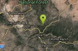
Maxwell Trail No. 37
Happy Jack, Arizona
17.8 miles EThe Maxwell Trail leads over the Mongollan Rim down the canyon into West Clear Creek. Although still somewhat steep, it is an easier hike than shorter neighboring Tramway trail, which shares its...
Hike, Swim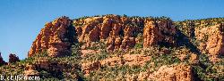
Red Rock State Park
Sedona, Arizona
20.5 miles NRed Rock in Sedona, Arizona details the beauty in the layers of sedimentary rock that has been constructed over millions of years. It is at Red Rock that you can see "Schnebly Hill...
Hike, Swim
Chavez Crossing
Sedona, Arizona
21.3 miles NChavez Crossing is a campground in Sedona, Arizona. It sits perfectly nestled in Arizona's most beautiful red rock attractions along with the grand summer sunsets. If that didn't sound...
Camp, Hike, Swim 6.0 mi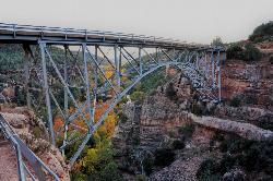
Huckaby Trail
Sedona, Arizona
22.7 miles NOn the hunt for adventure? Established in 1998, Huckaby Trail is just the adventuresome route for both avid hikers and mountain bikers. It offers up forestry of Arizona Sycamores and picturesque...
Canoe, Hike, Mountain Bike 8.5 mi
Munds Wagon Trail
Sedona, Arizona
23.2 miles NMunds Wagon Trail is different from many of the other more “classic†rides around Sedona. If you come from somewhere else and are missing the feel of loose rocks...
Hike, Mountain Bike
Midgley Bridge Trail
Sedona, Arizona
24.0 miles NHike near Sedona, Arizona
Hike
Wilson Mountain Trail
Sedona, Arizona
24.0 miles NHike near Sedona, Arizona
Hike 3.4 mi
Grasshopper Point
Sedona, Arizona
24.1 miles NGrasshopper Point is a beautiful swimming hole located in Sedona, Arizona. Grasshopper Point is the perfect place to cool off in the summer after a nice hike, or a hot summer day. This swimming...
Dive, Hike, Swim
Schnebly Hill Vista Overlook
Sedona, Arizona
24.1 miles NThe Schnebly Hill Formation is a beautiful red rock gem in Sedona, Arizona. This rock formation is considerably big, which is why it is divided into four different sections that are called...
Hike
Devil's Bridge
Sedona, Arizona
25.7 miles NWe loved the red rock views on this hike! It's a 3.6 mile round-trip trail, on rocky/sandy ground, and is fairly easy, until the last mile, which is steep. Dozens of jeeps and ATVs passed us -...
Hike


