


57 Hiking Trails near Slate Mountain Trail
first prev 1 2 3 next lastShowing Hiking Trails within 50 miles Distance miles of F5P7+C9 Parks, AZ, USA City, Zip, or Address
Red Mountain Trail
Flagstaff, Arizona
3.7 miles NHike
Kendrick Peak Trail
Flagstaff, Arizona
6.1 miles SWHike

Pumpkin Trail to Bulls Basin Trail Loop
Flagstaff, Arizona
6.1 miles SWHike
SP Crater
Flagstaff, Arizona
13.0 miles NEHike
Red Butte Trail
Williams, Arizona
27.3 miles NWDirections from Highway 64/180: Turn onto Forest Road (FR) 320. Travel east for 1.5 miles and turn left (north) onto FR 340. After traveling .75 mile on this road turn right (east) onto...
Hike
East Horseshoe Mesa Trail
Williams, Arizona
31.6 miles NWDirections from East Entrance: Drive west on East Rim Drive to Grandview Point access road. Turn right and follow the access road to the trailhead. Descend two miles on the Grandview...
Hike
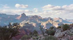
Arizona Trail
Grand Canyon Village, Arizona
33.2 miles NThe Arizona Trail, located near the Grand Canyon, is great from January through November. At 16.8 miles (one way) in distance, the trail is out and back and rated with high difficulty.
Hike, Horseback 1.0 mi
Harding Springs Trail
Sedona, Arizona
34.0 miles SHarding Springs Trail is a beautiful hiking trail in Sedona, Arizona. This trail was originally one of several that provided a way for cattlemen to drive their stock in and out of Oak Creek...
Hike 0.1-0.7 mi
Cave Springs
Sedona, Arizona
34.3 miles SCave Springs Campground is a scenic campground that sits in Oak Creek Canyon. Cave Springs is nestled perfectly in the town of Sedona, giving the campground the notorious Sedona red views. Uniquely,...
Camp, Hike, Swim
Tonto Trail: New Hance Trail to Grandview Point
Grand Canyon Village, Arizona
34.9 miles NBackpack, Camp, Hike 9.1 mi
New Hance Trail
Grand Canyon Village, Arizona
36.2 miles NNew Hance Trail is a colorful hike through Red Canyon to the Colorado River. This trail is considered one of the more difficult trails in the Grand Canyon and is a challenge only prepared hikers...
Backpack, Camp, Hike
Tonto Trail from Grandview Point to South Kaibab Trailhead
Grand Canyon Village, Arizona
36.3 miles NA rigorous point-to-point backpack of four to five days; recommended for experienced Grand Canyon backpackers only. Long stretches of this scenic, lonely segment of the Tonto Trail are...
Backpack, Camp, Hike
Grandview Trail Loop
Grand Canyon Village, Arizona
36.4 miles NThis is definitely not a mountain biking trail! I am a resident of Grand Canyon and know for sure. Also use of Mtn bikes on canyon trails is illegal in the Park....
Backpack, Camp, Cross-country Ski, Hike
Grandview Point to Horseshoe Mesa Trail
Grand Canyon Village, Arizona
36.4 miles NA rewarding day hike or backpack to a wooden mesa below the South Rim.
Backpack, Hike
Tusayan Ruin Walk Trail
Grand Canyon Village, Arizona
36.5 miles NDirections from East Entrance Station: Drive approximately 4 miles west along East Rim Drive to the Tusayan Museum.
Hike
Grandview Lookout
Grand Canyon Village, Arizona
37.1 miles NWHike

Tanner Trail
Grand Canyon Village, Arizona
37.8 miles NA rigorous rim-to-river backpack of three or more days, following one of the South Rim's more difficult trails. The unmaintained trail, recommended only for seasoned hikers, is...
Backpack, Camp, Hike
The Escalante Route Trail
Grand Canyon Village, Arizona
37.8 miles NThe route can be hiked in either direction, but this passage will be described from the perspective of a downcanyon hiker. Follow the Tanner Trail to the shoreline. Rocks placed at the...
Backpack, Hike 0.3 mi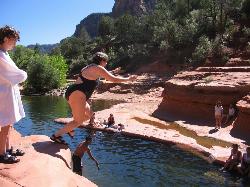
Slide Rock
Sedona, Arizona
37.8 miles SSlide Rock is one of the most popular locations in the Sedona area. Slide Rock is natures most thrilling water slides. Slide Rock is a gargantuan 80 feet long, and 2-4 feet wide. This slippery slope...
Hike, Swim
Desert View Visitor Center Trail
Grand Canyon Village, Arizona
38.3 miles NDirections from East Entrance Station: Drive westward less than a mile on East Rim Drive to reach the Desert View Visitor Center.
Hike


