


24 Hiking Trails near Kanarraville Falls
first prev 1 2 next lastShowing Hiking Trails within 50 miles Distance miles of 345 E 100 N St, Kanarraville, UT 84742, USA City, Zip, or Address
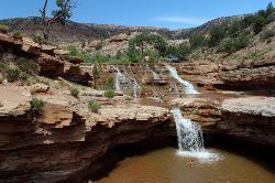
Toquerville Falls
La Verkin, Utah
16.9 miles SNothing says desert oasis quite like driving for 5.5 miles through winding sandy roads to find a favorite swimming hole with ledges, falls, and even a ladder to climb up to the best jumping spots....
Dive, Hike, Mountain Bike, Swim 7.5 mi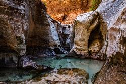
The Subway
Apple Valley, Utah
17.2 miles SEThe Subway is one of the best kept secrets of Zion National Park. A little off the beaten path, but a hike that is a must see for any adventure seeking person out there. Hikers begin at the Wildcat...
Canyoneer, Hike, Swim
Riverside Walk
Springdale, Utah
21.2 miles SEThe Virgin River has many moods, from quiet and slow to a raging torrent. This beautiful, shaded walk meanders through forested glens, following the path of the stream ever deeper into the...
Hike 3.3 mi
Guacamole Mesa
Virgin, Utah
21.7 miles SGuacamole Mesa, also known by locals as the Whole Guacamole, is an advanced level biking trail in Virgin, Utah (just outside of Hurricane). The trail starts in a climb up the mesa that features tight...
Hike, Mountain Bike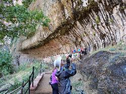
Weeping Rock
Springdale, Utah
22.6 miles SEExpect to get wet on this short hike! Weeping Rock gets its name from the continuous "weeping" of water that seeps through sandstone and drips from the cliffs above. Seasonal flowers...
Hike 2.6 mi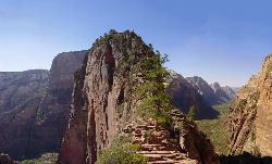
Angels Landing
Springdale, Utah
22.8 miles SEAngels Landing is one of the park's most strenuous day hikes, but it offers spectacular vistas. It follows the West Rim Trail through the famous switchbacks of Walters Wiggles, past dramatic...
Hike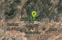
The Grotto Trail
Springdale, Utah
22.9 miles SEThe Grotto Trail is a short easy trail that connects The Grotto shuttle stop and Zion Lodge. It follows near the road for about 1.5 miles and has an elevation gain of about 130 feet.
Hike 1.1 mi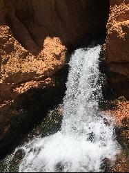
Cascade Falls
Cedar City, Utah
23.1 miles ECascade Falls, located outside of Cedar City, Utah, is a beautiful waterfall that is just a 1.2 mile hike round trip, ending at Cascade Falls. It is somewhat of a hidden local hotspot that not...
Hike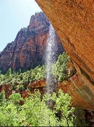
Emerald Pools Trail
Hurricane, Utah
23.1 miles SEThe Emerald Pools were named for their unusual color. At some times of the year, algae gives the water in these pools a distinctive hue. A series of basins have been carved into a rock ledge in the...
Hike 6.9 mi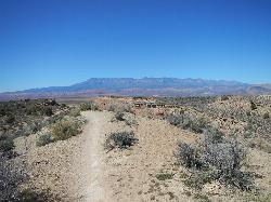
J.E.M. Trail
La Verkin, Utah
23.5 miles SThe J.E.M. trail is one of the many exciting trails located just outside of Hurricane, Utah. It is connected with the More Cowbell and Dead Ringer trails and is the longest of all three trails...
Hike, Mountain Bike 0.7 mi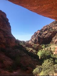
Red Reef trail
Hurricane, Utah
25.1 miles SWThe Red Reef trail is located near the small town of Leeds, Utah and in the Red Cliffs Desert Reserve. It is a 2 mile trail that takes hikers near the beautiful red slick rock cliffs of Southern...
Hike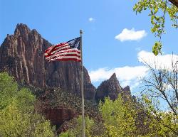
Zion National Park
Hurricane, Utah
25.3 miles SEThis is a unique place in the world. Sandstone,carved from wind, water and ice have created icons to visitors. The buttes, landings, bends, mounts and mountains have all been given names over the...
Camp, Hike, Mountain Bike, Swim 5.1 mi
Dead Ringer
Virgin, Utah
27.8 miles SThe Dead Ringer trail is one of three biking trails located just outside of Hurricane, Utah. Starting at the JEM trailhead, bikers start on a winding, up and down trail that runs parallel to the JEM...
Hike, Mountain Bike 3.4 mi
More Cowbell
Virgin, Utah
27.8 miles SThe More Cowbell loop, located outside of Hurricane, Utah, is a beginner level bike trail that gives riders a good feel for what mountain biking is like. It is a great practice run for bigger, more...
Hike, Mountain Bike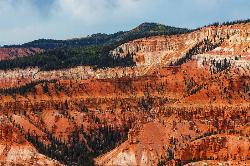
Dixie National Forest
Cedar City, Utah
28.8 miles EDixie National Forest is an often forgotten/hidden gem in Cedar City. It is over 2 million acres of beautiful red rock canyons and trees. Dixie Forest isn't only limited to rocks and...
Backpack, Camp, Hike 11.3 mi
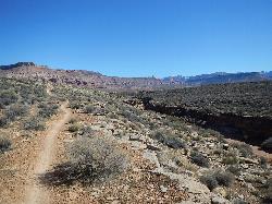
Grapevine Trail
Washington, Utah
31.9 miles SWThe Grapevine trail located near Washington, UT is a unique trail that connects to several other trails in the area such as the Prospector trail and the Church Rocks trail. What makes the Grapevine...
Hike, Mountain Bike 18.8 mi
Church Rocks
Washington, Utah
32.0 miles SWThe Church Rocks hike near Hurricane, Utah, about a half hour outside of St. George, is another hidden gem outside of Zion National Park. Similar to the Slick Rock Trail in Moab, there are lots...
Hike, Mountain Bike 0.7 mi
Snow Canyon Lava Caves
St. George, Utah
33.6 miles SWThese caves are located in Snow Canyon State Park near Dammeron Valley in Utah and it's one of the most unique places in southern Utah. Years ago, lava flowed through these caves until...
Cave, Hike 0.2-0.4 mi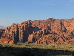
Snow Canyon State Park
St. George, Utah
34.5 miles SWSnow Canyon State park is often described as a smaller version of Zion National park. While both offer similar beautiful landscapes, exciting trails for adventure seeking hikers, and family friendly...
Cave, Hike, Mountain Bike, Rock Climb 0.1 mi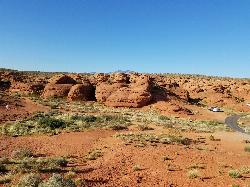
St. George Narrows
St. George, Utah
36.5 miles SWNot to be confused with the Narrows of Zion National Park, the St. George Narrows, also referred to by locals as the "Crack", are located near downtown St.George, Utah just a...
Hike


